

The Himalaya Mountain system is the world's youngest and highest fold mountain range, stretching for approximately 2,500 kilometres in an east-west arc from the Indus gorge in the west to the Brahmaputra gorge in the east. It covers around 5 lakh square kilometres across India, Nepal, Bhutan, China (Tibet) and Pakistan. The word "Himalaya" is Sanskrit for "abode of snow" (hima + alaya). For India, the Himalaya is far more than a physical barrier – it is a climatic regulator, a source of perennial rivers, a biodiversity reservoir and a strategic frontier.
Formation: Plate Tectonics and the Tethys Sea
The Himalaya is a result of the continental collision between the Indian Plate and the Eurasian Plate, which began around 50-55 million years ago in the Eocene epoch.
| Stage | Process |
|---|---|
| Pangaea break-up (200 million years ago) | India was part of southern Gondwana |
| Indian plate drift | Moved northwards at 15 cm per year for 100 million years |
| Tethys Sea | Shallow sea existed between India and Asia, depositing marine sediments |
| Collision (55 Ma) | Indian plate collided with Eurasian plate; sediments of the Tethys were folded, uplifted and crumpled |
| Ongoing uplift | The Himalaya is still rising at 5 mm to 1 cm per year |
This explains why marine fossils, including ammonites (Shaligrams), are found at heights above 5,000 metres in Nepal and Tibet. The continued collision also makes the Himalaya one of the world's most seismically active zones (Zones IV and V).
Three Parallel Ranges of the Himalaya
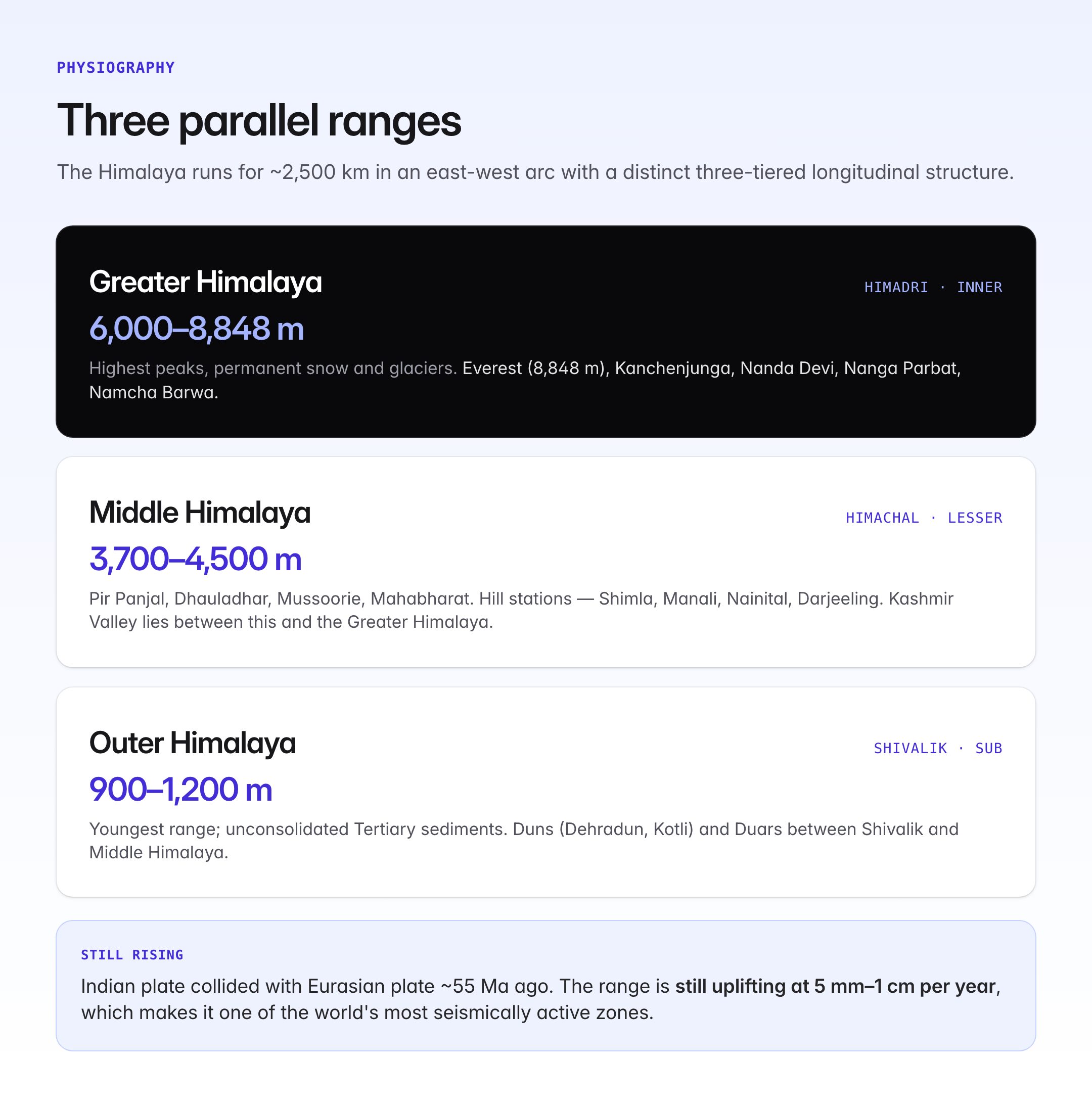
The Himalaya has a distinct three-tiered longitudinal structure.
| Range | Alternate Names | Elevation | Key Features |
|---|---|---|---|
| Greater Himalaya | Himadri, Inner Himalaya | 6,000-8,848 m | Highest peaks, permanent snow, glaciers |
| Middle Himalaya | Himachal, Lesser Himalaya | 3,700-4,500 m | Hill stations, famous ranges: Pir Panjal, Dhauladhar, Mussoorie, Mahabharat |
| Outer Himalaya | Shivalik, Sub-Himalaya | 900-1,200 m | Youngest, composed of unconsolidated sediments; Duns and Duars |
Greater Himalaya (Himadri)
Contains the world's highest peaks. Mount Everest (Sagarmatha / Chomolungma – 8,848.86 m) in Nepal, Kanchenjunga (8,586 m) on the India-Nepal border, Nanda Devi (7,816 m) in Uttarakhand, Nanga Parbat (8,126 m) in the west, and Namcha Barwa (7,756 m) in the east are located here. This range has permanent snowline (4,500-6,000 m) and massive glaciers.
Middle Himalaya (Himachal)
Includes Pir Panjal (longest range of the Middle Himalaya), Dhauladhar, Mussoorie, Nag Tibba and Mahabharat Lekh (Nepal). Famous hill stations – Shimla, Manali, Mussoorie, Nainital, Darjeeling – sit on this belt. The beautiful Valley of Kashmir lies between the Pir Panjal and the Greater Himalaya.
Shivalik (Outer Himalaya)
The youngest range, formed of Tertiary sediments (Miocene to Pliocene). It includes Jammu Hills, Dafla, Abor, Mishmi and Patkai Hills in the east. Between the Shivalik and the Middle Himalaya lie flat-floored longitudinal valleys called Duns (Dehradun, Kotli Dun, Patli Dun) and Duars (in the east).
Regional Divisions (West to East)
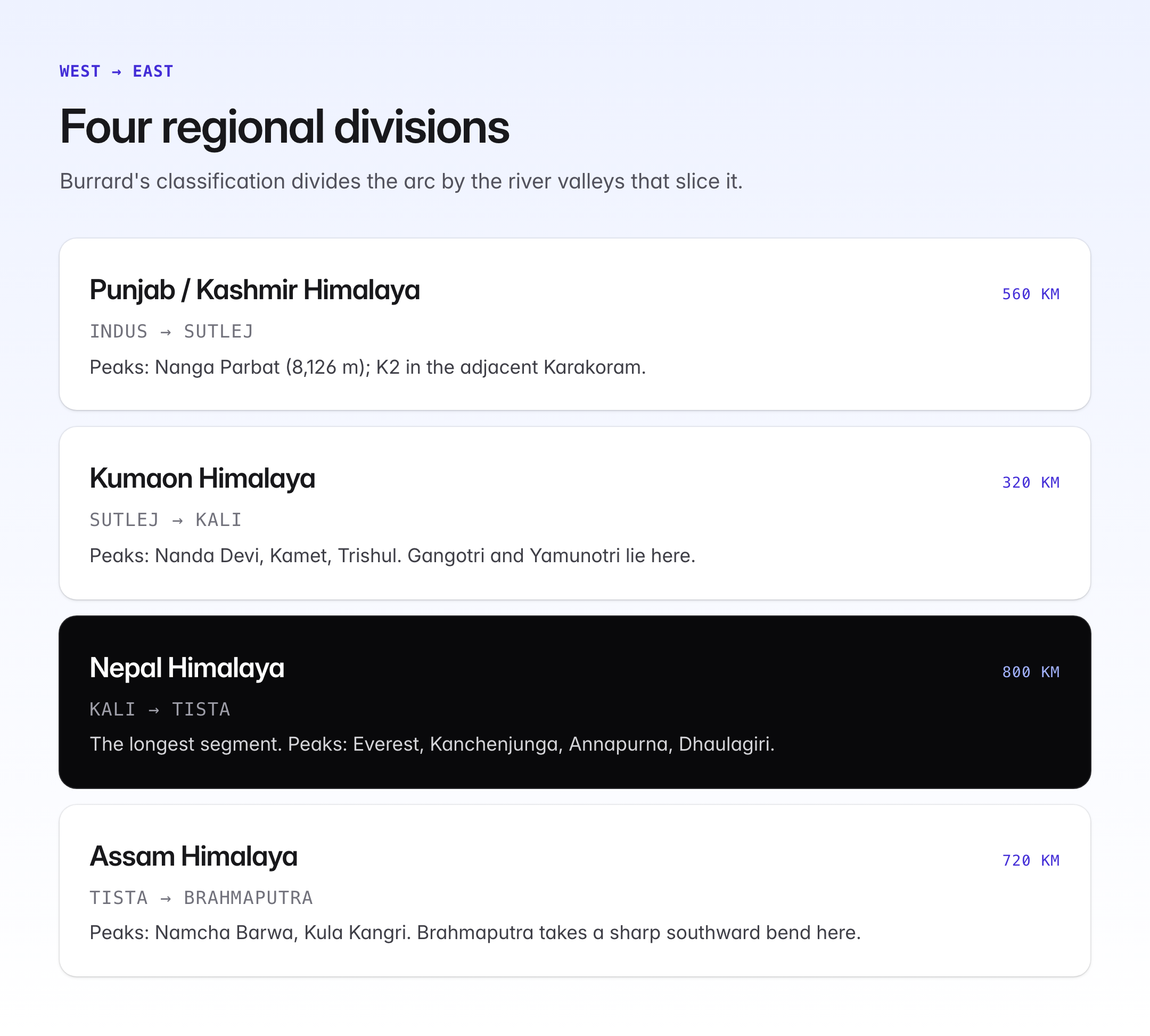
Sydney Burrard and later geographers divided the Himalaya by river valleys.
| Division | Extent | Length | Major Peaks |
|---|---|---|---|
| Punjab / Kashmir Himalaya | Indus to Sutlej | 560 km | Nanga Parbat, K2 (in Karakoram, adjacent) |
| Kumaon Himalaya | Sutlej to Kali | 320 km | Nanda Devi, Kamet, Trishul |
| Nepal Himalaya | Kali to Tista | 800 km | Everest, Kanchenjunga, Annapurna, Dhaulagiri |
| Assam Himalaya | Tista to Brahmaputra | 720 km | Namcha Barwa, Kula Kangri |
Major Passes
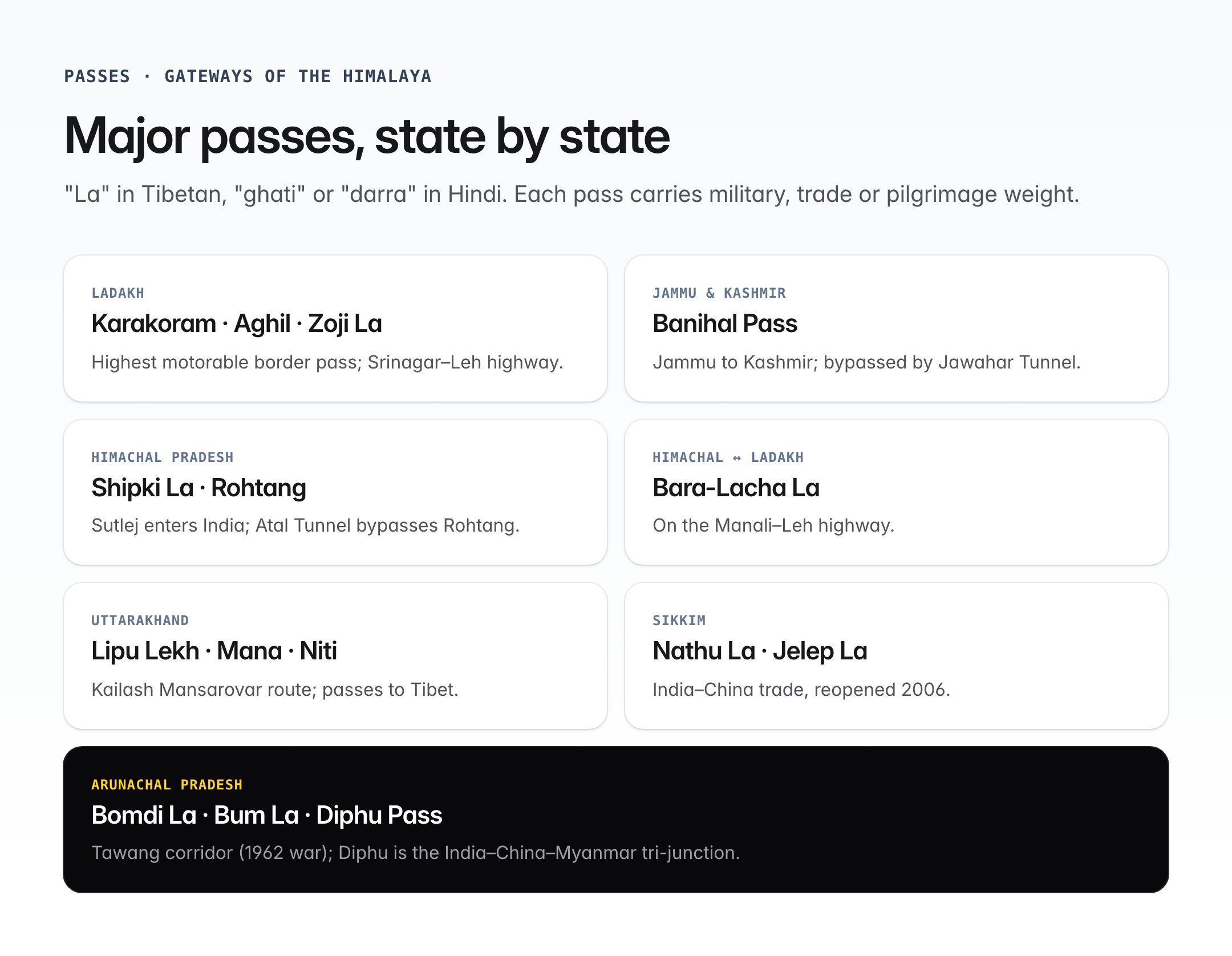
Passes ("La" in Tibetan, "Ghati" or "Darra" in Hindi) connect India to neighbouring regions and have military, trade and pilgrimage importance.
| Pass | State / Region | Significance |
|---|---|---|
| Karakoram Pass | Ladakh | India-China (Xinjiang), highest motorable border pass |
| Aghil Pass | Ladakh (Karakoram) | To Yarkand in Xinjiang |
| Zoji La | Kashmir | Srinagar-Leh highway |
| Banihal Pass | Pir Panjal | Jammu to Kashmir; bypassed by Jawahar Tunnel |
| Shipki La | Himachal Pradesh | Sutlej enters India; India-Tibet trade |
| Rohtang Pass | Himachal Pradesh | Kullu to Lahaul-Spiti; bypassed by Atal Tunnel |
| Bara-Lacha La | Himachal-Ladakh | Manali-Leh highway |
| Lipu Lekh | Uttarakhand | Kailash Mansarovar route |
| Mana and Niti | Uttarakhand | Near Badrinath, to Tibet |
| Nathu La and Jelep La | Sikkim | India-China trade, reopened 2006 |
| Bomdi La and Bum La | Arunachal Pradesh | Tawang corridor, 1962 war |
| Diphu Pass | Arunachal Pradesh | Tri-junction India-China-Myanmar |
Glaciers
The Himalaya holds the largest mass of ice outside the polar regions, earning the nickname "Third Pole".
| Glacier | Location | Significance |
|---|---|---|
| Siachen | Karakoram | Longest glacier outside the poles, source of Nubra |
| Gangotri | Uttarakhand | Source of Bhagirathi (Ganga) |
| Yamunotri | Uttarakhand | Source of Yamuna |
| Pindari, Milam | Uttarakhand | Feed Kumaon rivers |
| Zemu | Sikkim | Source of Tista |
| Bara Shigri | Himachal | Largest in Himachal |
Rivers Originating in the Himalaya
The Himalaya is the water tower of Asia, giving rise to the great perennial river systems.
| River | Source | Basin |
|---|---|---|
| Indus | Mansarovar region, Tibet | Indus Basin |
| Sutlej | Rakas Tal, Tibet | Indus Basin |
| Jhelum | Verinag spring, J&K | Indus Basin |
| Chenab | Bara-Lacha La, Himachal | Indus Basin |
| Ravi and Beas | Himachal Pradesh | Indus Basin |
| Ganga (Bhagirathi) | Gangotri, Uttarakhand | Ganga Basin |
| Yamuna | Yamunotri, Uttarakhand | Ganga Basin |
| Ghaghara, Gandak, Kosi | Nepal Himalaya | Ganga Basin |
| Brahmaputra (Tsangpo) | Angsi/Chemayungdung glacier, Tibet | Brahmaputra Basin |
Because of glacial melt plus monsoon runoff, these are perennial rivers – unlike peninsular rivers, which are rain-fed.
Biodiversity
The Himalaya is one of India's four biodiversity hotspots and part of the global Himalaya and Indo-Burma hotspots.
| Zone | Vegetation | Fauna |
|---|---|---|
| Tropical (up to 1,500 m) | Sal, teak, bamboo | Tiger, elephant, hornbill |
| Temperate (1,500-3,500 m) | Oak, rhododendron, pine | Himalayan tahr, langur |
| Alpine (3,500-5,000 m) | Silver fir, birch, juniper, alpine grasses | Snow leopard, brown bear, blue sheep |
| Glacial (above 5,000 m) | Lichens, mosses | Snow cock, yak |
The region is home to endangered species such as the snow leopard, red panda, musk deer, Kashmir stag (Hangul), Himalayan monal and Asiatic black bear.
Significance for Indian Climate and Monsoon
The Himalaya is indispensable to India's climate system.
- Blocks the cold, dry northerly winds from Central Asia in winter, keeping the North Indian plains far warmer than comparable latitudes elsewhere (such as north China).
- Forces the southwest monsoon to shed its moisture on the Indian subcontinent, giving the plains their defining rainy season.
- Creates a rain shadow on the Tibetan Plateau and parts of Ladakh.
- Feeds perennial rivers through glacial melt, especially in summer before the monsoon.
- Influences western disturbances, steering them to deliver winter rain and snow to North India and the Himalaya.
Without the Himalaya, India would have a climate resembling the Sahel and agriculture in the Gangetic plain would collapse.
Strategic and Cultural Importance
The Himalaya forms India's northern frontier with China, Nepal and Bhutan, making it central to national security. Sacred sites such as Kailash-Mansarovar, Amarnath, Kedarnath, Badrinath, Gangotri and Yamunotri (Char Dham), and Hemkund Sahib lie in the Himalaya, attesting to its deep cultural-religious hold on the Indian imagination.
Environmental Threats
Contemporary concerns include glacial retreat due to climate change, Glacial Lake Outburst Floods (GLOFs) such as the 2013 Kedarnath and 2023 Sikkim disasters, landslides, unsustainable hydropower and road projects, loss of snow cover, and biodiversity decline.
UPSC Relevance
Prelims: Factual questions on passes and their states, source rivers, highest peaks, locations of glaciers, biodiversity hotspots, and the three-range structure are routine. Match-the-pair formats are common.
Mains GS-1 (Geography): Himalaya appears in questions on Indian physiography, impact of the Himalaya on monsoon and climate, river systems, glacial geomorphology and regional divisions of India.
Mains GS-3 (Environment, Disaster Management): Themes include climate change and glacier retreat, GLOFs, landslides, Hindu Kush Himalaya Assessment, hydropower policy in ecologically fragile zones, and biodiversity conservation.
GS-2 (International Relations): The Himalaya frames India-China border disputes (LAC, Doklam, Galwan), India-Nepal boundary issues (Kalapani, Lipu Lekh) and India-Bhutan strategic partnership.
Candidates should memorise the three ranges, four regional divisions, at least ten major passes, the Big Three rivers and four biodiversity zones to cover most Himalayan prompts across GS papers.
Tell Google you want more of this.
Add Anantam IAS as a preferred sourceOne tap, and this site shows up more often in your own Top Stories, AI Overviews and AI Mode. Remove it any time.






