The Indian subcontinent sits between the Arabian Sea and the Bay of Bengal, two warm tropical oceans that breed cyclones at predictable seasonal intensity. The peninsula receives almost all its annual rainfall from a four-month monsoon whose onset, withdrawal, and intra-seasonal variability shape every harvest. The Himalayan headwaters of every major north Indian river depend on the timing of western disturbances and on snow accumulation that satellites can see in ways that no ground network can match. Weather forecasting is therefore not an academic luxury for India. It is a public service whose accuracy translates directly into saved lives during cyclones, into harvest yields during the monsoon, and into water management decisions across half a billion people.
INSAT-3DS is the latest spacecraft in the line of Indian geostationary meteorological satellites that anchor this forecasting system. The satellite was launched on 17 February 2024 by GSLV Mk II-F14 from the Satish Dhawan Space Centre at Sriharikota. It is operated jointly by the Indian Space Research Organisation and the Ministry of Earth Sciences, with the India Meteorological Department as the principal user agency. The mission is funded by the Ministry of Earth Sciences, the platform is built by ISRO, and the data feeds the entire civilian weather forecasting and disaster management pipeline.
This article walks through what INSAT-3DS actually does, the four categories of payload it carries, the launch and orbit, the role inside the IMD forecasting workflow, the contribution to cyclone tracking and disaster warning, the relation to other INSAT and EOS satellites, and the policy outlook for the next-generation INSAT-4 series.
What the Acronym Means
INSAT-3DS stands for Indian National Satellite-3DS. The INSAT series is a long-running family of Indian communication and meteorological satellites that started in the early 1980s. The number 3 indicates the third major generation of the series, which began with INSAT-3A. The DS suffix indicates that this is a dedicated meteorological satellite, with no transponders for telecommunications or broadcasting. Earlier INSAT satellites combined meteorological payloads with C-band and S-band communication transponders. The 3D and 3DR satellites that preceded INSAT-3DS were the first to drop the communications role and focus entirely on meteorology. INSAT-3DS continues that line.
The Launch and the Orbit
The launch vehicle was the Geosynchronous Satellite Launch Vehicle Mk II, flight number F14. GSLV Mk II is the workhorse Indian rocket for medium-class geostationary missions, with a cryogenic upper stage that gives it the capability to deliver about two and a half tonnes to geostationary transfer orbit. The launch profile took INSAT-3DS into a transfer orbit, after which the satellite’s onboard liquid apogee motor circularised the orbit at the geostationary altitude.
A geostationary orbit is at roughly 35,786 kilometres above the equator, where the orbital period equals the Earth’s rotation period. A satellite in this orbit appears stationary relative to a point on the Earth’s surface. INSAT-3DS is positioned over the Indian Ocean at a longitude that gives its imager full coverage of the Indian subcontinent, the Bay of Bengal, the Arabian Sea, and adjacent landmasses across South Asia and East Africa. The design life of the satellite is approximately seven to ten years, after which a successor will be needed.
The Four Payload Categories
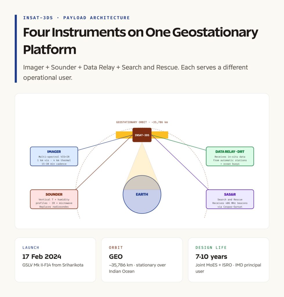
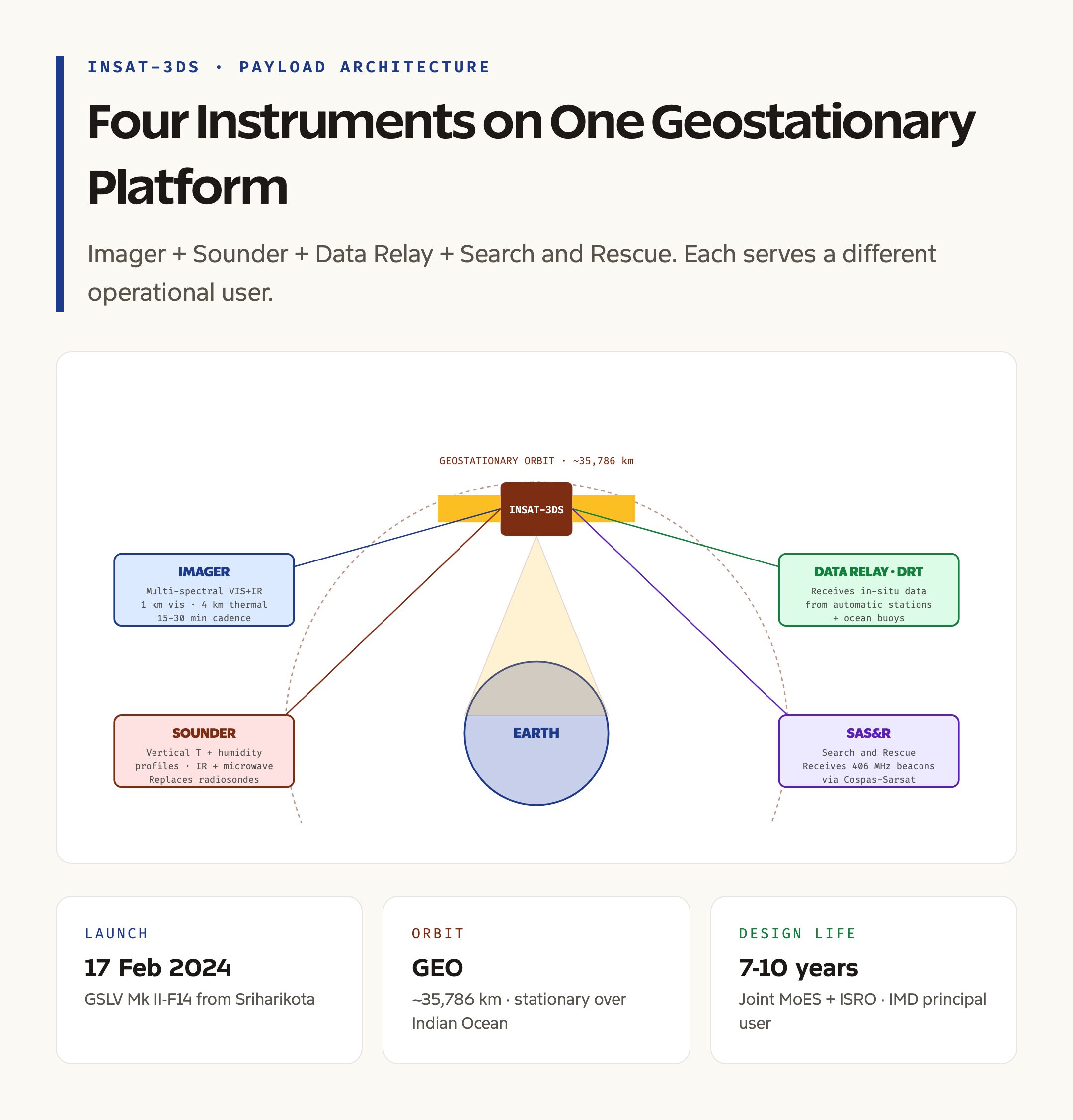
INSAT-3DS carries four distinct payload categories, each serving a different operational function. The first is the Imager, a multi-spectral optical instrument that captures images of cloud cover, land surface, and ocean surface across visible, infrared, and water vapour bands. The Imager produces full-disk images of the Indian region every fifteen to thirty minutes during normal operations, with a faster rapid-scan mode that can produce images every few minutes during severe weather. The spatial resolution is one kilometre in the visible band and four kilometres in the thermal infrared band. The water vapour channel maps mid-tropospheric moisture, which is critical for monsoon and cyclone forecasting.
The second is the Sounder, which is a vertical atmospheric profiler. The Sounder takes spectral measurements at multiple wavelengths in the infrared and microwave region, and through inverse retrieval algorithms it produces vertical profiles of temperature, humidity, and trace gas concentration through the troposphere and lower stratosphere. The Sounder is the spaceborne equivalent of the radiosonde balloons launched twice daily from IMD ground stations, but with continuous coverage over the full satellite footprint rather than discrete launches at sparse points.
The third is the Data Relay Transponder, abbreviated DRT. The DRT is not an Earth observation instrument. It is a communication payload that receives small data packets from automatic weather stations and ocean buoys deployed across the Indian region, and relays them to the IMD ground network. The DRT effectively turns the satellite into a relay node for a sparse network of in-situ sensors that would otherwise have no way to send data from remote locations.
The fourth is the Satellite Aided Search and Rescue payload, abbreviated SAS&R. SAS&R receives distress signals from emergency beacons on ships, aircraft, and trekkers operating in the satellite’s footprint. The signals are relayed to the Indian Mission Control Centre at the Indian Space Research Organisation, which coordinates with the Coast Guard, the Air Force, and other rescue agencies to dispatch help. SAS&R is part of the international Cospas-Sarsat network, and the Indian payload supplements similar payloads on satellites operated by other countries.
How INSAT-3DS Plugs Into the IMD Forecasting Pipeline
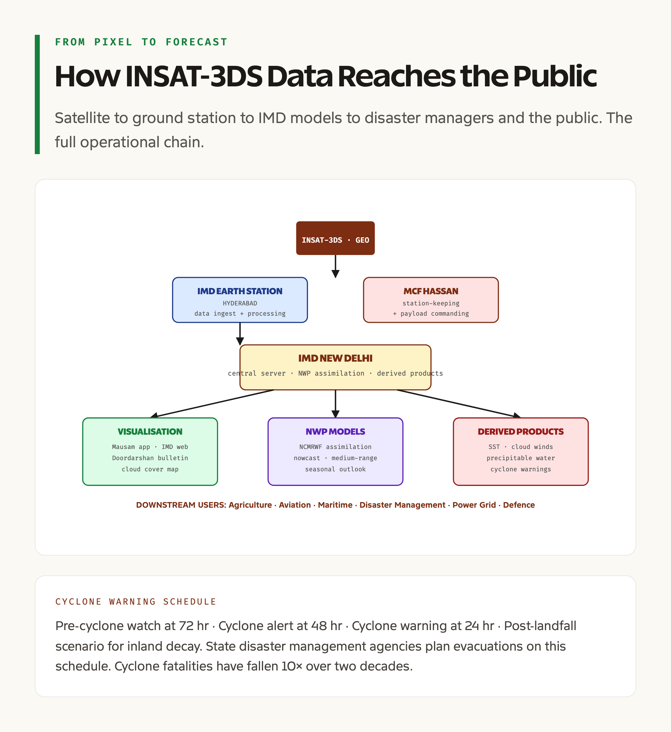
The data from INSAT-3DS flows into the India Meteorological Department’s operational forecasting system at the IMRC, the INSAT Meteorological Data Processing System, located at IMD New Delhi and at the IMD Earth Station Hyderabad. The raw satellite data is decoded, calibrated, geo-referenced, and stored. From there it feeds three downstream uses.
The first is direct visualisation. The imager pictures are displayed on the IMD Mausam app, on the IMD website, and on Doordarshan weather bulletins. The familiar cloud cover map that appears in the evening news is built directly from INSAT-3DS imagery. The second is assimilation into numerical weather prediction models. The IMD operates the IMDPS-NCMRWF chain, which combines satellite data, ground observations, and physical models to produce forecasts at scales from local nowcast through medium-range and seasonal outlook. The Sounder profiles are particularly valuable here because they constrain the model’s vertical structure of temperature and moisture, which is otherwise the largest source of forecast error.
The third is product generation. The IMD generates derived products from INSAT-3DS data including sea surface temperature maps, cloud-motion-vector wind estimates, total precipitable water maps, lightning frequency maps from the lightning-detection sensor, and quantitative precipitation estimates from infrared and microwave channels. Each derived product feeds specific user agencies including the agricultural advisory system, the aviation weather service, the maritime forecasting service, and the disaster management agencies at the centre and the states.
Cyclone Tracking and the Disaster Warning Workflow
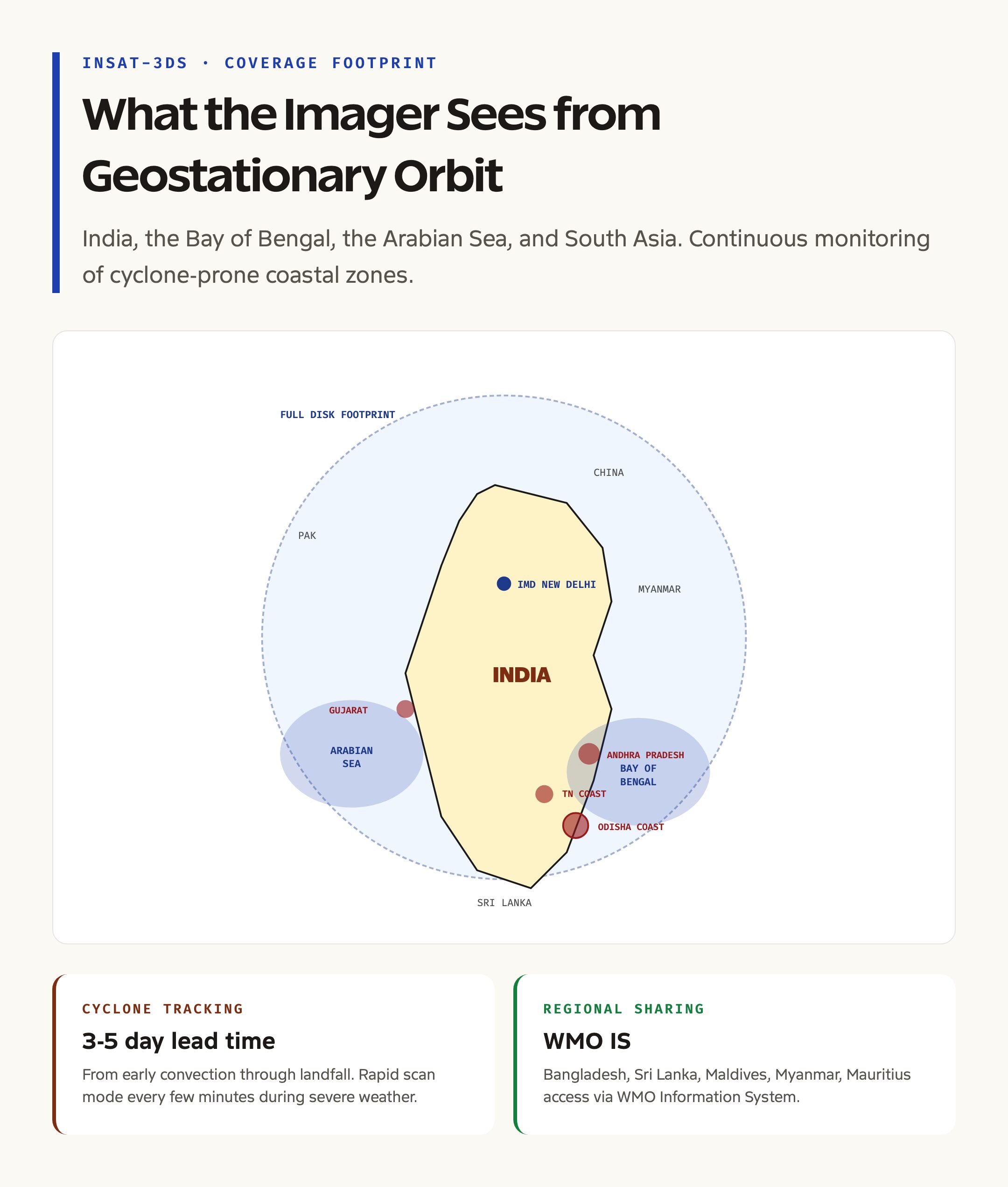
Cyclone tracking is the most public-facing use of INSAT-3DS. A tropical cyclone in the Bay of Bengal or the Arabian Sea typically takes three to five days from initial cloud cluster to landfall. INSAT-3DS captures the system from the earliest organisation of deep convection through the eyewall formation, the intensification, the track, and the eventual decay. The satellite’s rapid scan mode, which captures images every few minutes, is the primary tool for monitoring the eye position and the central pressure inferred from cloud-top temperature.
The IMD cyclone warning division uses INSAT-3DS imagery in combination with ground-based Doppler weather radars along the coast, ocean buoys, and reconnaissance flights to issue four levels of warning. The pre-cyclone watch is issued seventy-two hours before expected landfall. The cyclone alert at forty-eight hours. The cyclone warning at twenty-four hours. The post-landfall scenario covers the inland decay and rainfall risk. The state government disaster management agencies, particularly in Odisha, Andhra Pradesh, West Bengal, Tamil Nadu, Maharashtra, and Gujarat, plan evacuations and shelter activations on the basis of these warnings. The cyclone fatality rate in India has fallen by an order of magnitude over the past two decades, and the satellite-fed warning system is one of the main reasons.
The INSAT and EOS Family
INSAT-3DS does not work alone. It is part of a broader Indian Earth observation and meteorological satellite constellation. INSAT-3D, launched in 2013, was the first dedicated meteorological satellite of the 3D family. INSAT-3DR followed in 2016 and continues to operate. INSAT-3DS, launched in 2024, is designed to take over from these aging predecessors and to extend continuous geostationary coverage of India through the 2030s.
Beyond the geostationary INSAT line, India operates several Earth observation satellites in low Earth orbit through the EOS series, including EOS-08 and the recent SAR satellites including NISAR. Low Earth orbit satellites give higher spatial resolution but pass over a given location only a few times a day. Geostationary satellites give continuous coverage of a hemisphere at lower spatial resolution. The two regimes complement each other in the operational forecasting and disaster management pipeline, and the IMD system ingests data from both.
The Oceansat series serves marine forecasting specifically, including sea surface temperature, ocean colour, and wave climate. The RISAT and EOS SAR satellites give all-weather imaging through cloud cover and at night. The Cartosat series serves cartography and high-resolution land use mapping. INSAT-3DS sits at the centre of this ecosystem as the workhorse for atmospheric monitoring.
Ground Segment and Data Distribution
The ground segment for INSAT-3DS is anchored at the IMD Earth Station in Hyderabad and at the Master Control Facility at Hassan, both operated under the joint MoES-ISRO arrangement. Hassan handles satellite operations including station-keeping manoeuvres, payload commanding, and health telemetry. Hyderabad ingests the meteorological data, processes it into operational products, and pushes the products to the IMD New Delhi central server, from where downstream agencies access them.
The data is shared internationally through the World Meteorological Organisation Information System. The Bay of Bengal and Indian Ocean rim countries including Bangladesh, Sri Lanka, Maldives, Myanmar, and Mauritius receive the products through the WMO network and use them in their own national forecasting systems. The reciprocity is part of India’s regional public goods provision through the Indian Space Policy 2023 and through bilateral cooperation agreements with neighbouring meteorological services.
What Comes Next: The INSAT-4 Series
The next generation of Indian geostationary meteorological satellites is in conceptual planning at ISRO and the Ministry of Earth Sciences. The INSAT-4 series is expected to deliver higher spatial resolution, higher temporal resolution including continuous full-disk scans, additional sounder channels for greenhouse gas monitoring, and improved data relay capacity. The INSAT-4 line will also include payloads for atmospheric chemistry monitoring, particularly aerosol concentration and trace gas detection, which are increasingly relevant for air quality forecasting in north Indian cities.
The procurement and launch schedule for INSAT-4 has not been publicly fixed, but the broad expectation is a first satellite in the late 2020s, with INSAT-3DS continuing to anchor operational coverage until then. The integration with ISRO missions more broadly, with the Indian space policy framework for private sector participation, and with the international meteorological cooperation network will shape the design of the new series.
Why INSAT-3DS Matters for UPSC
For UPSC preparation, INSAT-3DS matters because it ties together several recurring themes. It is a working example of how a public-sector space programme directly serves disaster risk reduction, agricultural planning, aviation safety, and maritime safety. It connects ISRO, the Ministry of Earth Sciences, the IMD, and state disaster management agencies in a single operational pipeline. It demonstrates the value of geostationary versus low Earth orbit constellations for different operational needs. And it sits at the intersection of climate adaptation policy, food security, and the broader question of how a developing country builds public goods through its own space capacity. Each of those threads is examinable across GS-I, GS-II, and GS-III, and INSAT-3DS is one of the cleanest worked examples of all of them at once.
Tell Google you want more of this.
Add Anantam IAS as a preferred sourceOne tap, and this site shows up more often in your own Top Stories, AI Overviews and AI Mode. Remove it any time.