Ask most people which peak is the highest in India and they will say Everest. It is a confident, reasonable answer, and it is wrong. Everest sits on the Nepal–China border, not on any Indian boundary. The highest point inside India is Kanchenjunga, standing at 8,586 metres on the Sikkim frontier. It is also the third-highest mountain on Earth. That one fact, once it lodges, reorganizes a whole cluster of things you thought you knew about the Himalaya.
Here is the part that trips up almost everyone: Kanchenjunga is not one clean spike. It is a massif of five separate summits, it straddles two countries, it feeds a river that keeps north Bengal alive, and it holds a religious taboo that has protected its exact summit for seventy years. Get those layers straight and you will never mix it up with Everest again.
Where Kanchenjunga ranks and how far behind the leaders it sits
Kanchenjunga is the third-highest peak in the world at 8,586 metres (28,169 feet), behind Mount Everest (8,849 m) and K2 (8,611 m). The gap to the top is smaller than it sounds: only about 263 metres separate it from Everest, roughly the height of a 70-storey building stacked on an already unimaginable wall of rock and ice.
Within India, there is no contest. Kanchenjunga is the country’s highest point, and every other Indian summit, including Nanda Devi in Uttarakhand at 7,816 m, sits well below it. So the mountain does double duty in your memory: world number three, India number one.
That “K2 is second” detail matters because people assume the order runs Everest, Kanchenjunga, K2. It does not. K2, on the India–Pakistan (Pakistan-administered) side of the Karakoram, edges past Kanchenjunga by just 25 metres. The clean way to hold it: Everest, then K2, then Kanchenjunga, and only Kanchenjunga lies on India’s own border.
| Attribute | Detail |
|---|---|
| Height | 8,586 m (28,169 ft) |
| Global rank | 3rd highest on Earth |
| Rank in India | Highest peak in the country |
| Location | Sikkim (India)–Taplejung (Nepal) border |
| Range | Great Himalayas, Kangchenjunga Himal section |
| Name meaning | “Five Treasures of Snow” |
| Major glacier | Zemu (largest in the Eastern Himalaya) |
| River system fed | Teesta |
| First ascent | 25 May 1955, Joe Brown and George Band (British expedition) |
| Protected area | Khangchendzonga National Park (UNESCO mixed World Heritage Site, 2016) |
What “Five Treasures of Snow” actually refers to
The name Kanchenjunga comes from the Tibetan Kang-chen-dzö-nga, which translates as the “Five Treasures of Snow.” It is not decorative. The five treasures are the five repositories the local Buddhist tradition believes the mountain guards for the faithful: gold, silver, gems, grain, and holy scriptures. In lean times, the belief goes, the deity of the mountain reveals these treasures to the devout.
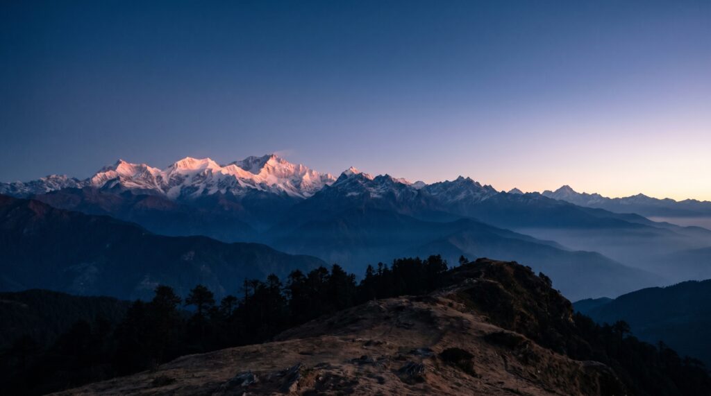
The number five is doing real geographic work too. Kanchenjunga is a cluster of five distinct peaks, and the “five treasures” map onto them. The main summit is the 8,586 m giant. The others are Kangchenjunga West, also called Yalung Kang, at 8,505 m; Kangchenjunga Central at 8,482 m; Kangchenjunga South at 8,494 m; and Kangbachen at 7,903 m. Three of those five clear 8,000 m, which is why the whole massif reads as a single wall of white from the Darjeeling ridge.
That is the mental picture to carry: not a lone triangle like the postcard Everest, but a broad, many-shouldered fortress. When you see it at dawn from Tiger Hill near Darjeeling, catching the first light before the plains do, you are looking at all five treasures at once.
The India–Nepal border and the range it belongs to
Kanchenjunga sits on the boundary between the Indian state of Sikkim and Nepal’s Taplejung district, in the Great Himalayas, the highest and northernmost of the three parallel Himalayan ranges. This is the axial belt of the mountain system, the one that carries the permanent snow line and nearly all the 8,000 m peaks.
To fix the range order, work south to north across the Himalaya: the Shiwaliks (the low outer foothills), then the Lesser or Middle Himalaya (the Pir Panjal, Dhauladhar, and Mahabharat ranges, home to hill stations like Shimla and Darjeeling), then the Great Himalaya or Himadri, where Kanchenjunga lives. Everest, Makalu, and Lhotse belong to this same innermost belt, just further west along the arc into Nepal. If you have worked through the physical features of the Himalayas, Kanchenjunga is simply the eastern anchor of that top tier.
The Sikkim location also explains the mountain’s outsized cultural weight, which the next sections build on. A peak this dominant, visible from Gangtok and Darjeeling on a clear morning, was never going to be just rock to the people living beneath it.
The Zemu Glacier and the Teesta it feeds
Kanchenjunga is the source of several large glaciers, and the biggest of them, the Zemu Glacier on the northeastern flank, is the largest glacier in the Eastern Himalaya at about 26 kilometres long. Zemu is not a curiosity. Its meltwater is the headstream of the Teesta, the river that drains most of Sikkim and much of northern West Bengal before joining the Brahmaputra in Bangladesh.
Follow the water and the mountain stops being an abstraction. The other major ice bodies radiating off the massif are the Talung, Yalung, and Kangchen glaciers, each pointing down a different face. Together they make Kanchenjunga a genuine water tower for the region, the same role the western Himalayan glaciers play for the Indus and Ganga systems.
That is also why the mountain shows up in climate conversations. Eastern Himalayan glaciers, Zemu included, have been thinning and retreating, and a shrinking Zemu directly threatens the Teesta’s dry-season flow and the hydropower and farming that depend on it. When you revise Himalayan glaciers and climate change or the Himalayan rivers and drainage system, Kanchenjunga and Zemu are your concrete Eastern-Himalaya example, not a distant textbook one.
Khangchendzonga National Park: India’s first mixed World Heritage Site
The protected area around the peak, Khangchendzonga National Park, was inscribed on the UNESCO World Heritage List in 2016 as India’s first “mixed” site, meaning it qualified on both natural and cultural grounds at once. That “mixed” tag is the detail worth underlining, because India has many natural World Heritage sites and many cultural ones, but Khangchendzonga was the first to be recognized for both together.
The natural case is straightforward: a dramatic sweep of altitude from around 1,200 m to the 8,586 m summit, packing subtropical forest, temperate woodland, alpine meadow, and permanent ice into one park, with a rich roster of threatened species. The cultural case is subtler and rests on the sacred meaning of the mountain to Sikkim’s communities, which UNESCO explicitly cited.
Layer on two more designations so you do not confuse them. The wider region is the Khangchendzonga Biosphere Reserve, and in 2018 it was added to UNESCO’s World Network of Biosphere Reserves under the Man and the Biosphere Programme. So the same landscape carries a national park at its core, a biosphere reserve around it, and a World Heritage listing over the top. If your notes on biosphere reserves of India and national parks of India keep these three labels apart, you have the whole administrative picture. You can read the official listing on the UNESCO World Heritage Centre page.
The wildlife, stacked by altitude
Khangchendzonga’s animals sort themselves by elevation, and the headline residents are the ones every conservation list flags: the snow leopard high on the crags, the red panda in the temperate bamboo forests lower down, and the Himalayan black bear, musk deer, and Himalayan tahr in between. The red panda is Sikkim’s state animal, which is a clean way to anchor it to place.
The vertical range is the real story here. Because the park climbs through so many climate zones in a short horizontal distance, it holds species that would normally be spread across hundreds of kilometres of latitude. Blood pheasant (Sikkim’s state bird) and Himalayan monal work the alpine scrub; the forests below carry rhododendron and orchid diversity that few Indian parks can match.
For the conservation angle, note that the snow leopard and red panda are both listed as threatened on the IUCN Red List, and Khangchendzonga is one of their most important Indian strongholds. That is the sentence that connects this peak to the broader wildlife conservation syllabus rather than leaving it as scenery.
Why nobody stands on the exact summit
Kanchenjunga was first climbed on 25 May 1955 by Joe Brown and George Band of a British expedition led by Charles Evans, and they deliberately stopped a few metres short of the true summit. That was not exhaustion or bad weather. It was a promise. Before the climb, the team had assured the Chogyal (Maharaja) of Sikkim that the sacred top would remain untouched out of respect for local belief.
That single act of restraint became a tradition. Most climbers who have reached the peak since have honoured it, halting just below the highest point so the summit itself stays, in a sense, inviolate. It is one of the few great mountains in the world where the recognized custom is to not quite finish the last few steps.
The belief behind it runs deep. To the Lepcha, the indigenous people of Sikkim, and to the Bhutia community, Kanchenjunga is a guardian deity, not merely a landmark. The Pang Lhabsol festival, celebrated across Sikkim, honours the mountain as the state’s protective god. So when you write about Kanchenjunga, “sacred” is a load-bearing fact with a documented consequence, not a soft cultural footnote. That crossover, a natural feature carrying binding religious meaning, is exactly why UNESCO could call the park a mixed site.
How to lock Kanchenjunga into your notes
The efficient way to revise this peak is to build it as a five-fact spine and hang everything else off it: height and rank, name and five summits, border and range, glacier and river, and the sacred-summit taboo. Almost every question worth asking about Kanchenjunga is a variation on one of those five.
Start with the ranking, because it is the highest-yield trap. Drill Everest, K2, Kanchenjunga as the top three in that order, and separately drill that Kanchenjunga is India’s highest. Those two statements are both true and people routinely blur them into a single wrong sentence (“Everest is India’s highest”). Keep them apart on the page.
Then group the labels. Khangchendzonga National Park, the biosphere reserve, and the mixed World Heritage Site are three different designations for one landscape, and confusing them is the second common slip. A tiny table with three rows fixes it faster than a paragraph. Do the same three-way sort for the UNESCO World Heritage sites in India so the “first mixed site” claim has company to compare against.
Last, tie the physical facts to a consequence. Zemu is not worth memorizing as a name; it is worth memorizing as the source of the Teesta and as an Eastern-Himalayan glacier that is retreating. The red panda is not trivia; it is a threatened species and Sikkim’s state animal. Facts anchored to a “so what” survive revision. Loose ones evaporate.
Frequently Asked Questions
Is Kanchenjunga the highest peak in India?
Yes. At 8,586 m it is the highest point in India and the third-highest mountain in the world. Everest and K2 are taller, but neither lies on an Indian border. Everest sits on the Nepal–China boundary, so it is not an Indian peak at all.
Where exactly is Kanchenjunga located?
On the border between the Indian state of Sikkim and Nepal’s Taplejung district, in the Great Himalayas. It is visible on clear mornings from Darjeeling and Gangtok.
What does the name Kanchenjunga mean?
It means the “Five Treasures of Snow,” from the Tibetan Kang-chen-dzö-nga. The five treasures are gold, silver, gems, grain, and holy scriptures, and the massif itself has five main peaks.
Why do climbers not step on the actual summit?
Out of respect for local religious belief. The 1955 first-ascent team promised the Chogyal of Sikkim they would leave the sacred top untouched, and most climbers since have kept that custom by stopping just short.
What is special about Khangchendzonga National Park?
It became India’s first “mixed” UNESCO World Heritage Site in 2016, recognized for both its natural value and the cultural and religious significance of the mountain to Sikkim’s people.
Which river does Kanchenjunga feed?
The Teesta. Its headstream is meltwater from the Zemu Glacier, the largest glacier in the Eastern Himalaya, which flows off the mountain’s northeastern face.
Which rare animals live around Kanchenjunga?
The snow leopard, the red panda (Sikkim’s state animal), the Himalayan black bear, and the musk deer, among others. Both the snow leopard and red panda are listed as threatened on the IUCN Red List.
When was Kanchenjunga first climbed?
On 25 May 1955, by Joe Brown and George Band of a British expedition led by Charles Evans.
Practice Questions
1. Kanchenjunga is which of the following?
a) The highest peak in the world
b) The second-highest peak in the world
c) The third-highest peak in the world and the highest in India
d) The highest peak in Nepal
Answer: c
2. On which international border does Kanchenjunga lie?
a) India–China
b) India–Nepal
c) India–Bhutan
d) India–Pakistan
Answer: b
3. Khangchendzonga National Park is notable for being:
a) India’s largest tiger reserve
b) India’s first “mixed” UNESCO World Heritage Site
c) India’s first national park
d) India’s only cold desert biosphere reserve
Answer: b
4. The Zemu Glacier, which rises on Kanchenjunga, is the headstream of which river?
a) Brahmaputra
b) Ganga
c) Teesta
d) Kosi
Answer: c
5. Which of these species is the state animal of Sikkim and is found around Kanchenjunga?
a) Snow leopard
b) Red panda
c) Himalayan tahr
d) Musk deer
Answer: b
Mains-style questions
1. Kanchenjunga became India’s first mixed natural-and-cultural World Heritage Site. Discuss how a single landscape can qualify on both grounds, using this example. 2. Explain the role of Eastern Himalayan glaciers such as Zemu in the region’s water security, and the risks posed by their retreat. 3. Distinguish between a national park, a biosphere reserve, and a World Heritage Site, using the Khangchendzonga landscape to illustrate the differences. 4. “Sacred geography shapes conservation as much as ecology does.” Examine this statement with reference to Kanchenjunga. 5. Describe the three parallel ranges of the Himalayan system and locate Kanchenjunga within them.
Kanchenjunga rewards the aspirant who refuses to treat it as scenery. The height and the rank are the entry ticket, but the mountain earns its place in your preparation because it ties together so many threads at once: Himalayan physiography, glacier-fed rivers, a threatened-species stronghold, a first-of-its-kind World Heritage listing, and a living religious tradition strong enough to keep human feet off the summit for seven decades. Learn it as that bundle, not as a single number, and it stops being a peak you can confuse with Everest and becomes one you can actually explain.
Tell Google you want more of this.
Add Anantam IAS as a preferred sourceOne tap, and this site shows up more often in your own Top Stories, AI Overviews and AI Mode. Remove it any time.