In the parched plains of western Rajasthan, where annual rainfall is concentrated into a few weeks of monsoon and the rest of the year is dry, water has always been the limiting resource. The land has responded by developing one of the densest networks of traditional water harvesting structures anywhere in the world. Johads, talabs, baolis, kunds, tankas, virdas, and khailis form a typological family that varies by terrain, soil, and use. Each name carries a slightly different design, a slightly different community of use, and a slightly different ecological role.
Among these, the khaili is perhaps the least documented and most recently revived. A khaili is a shallow village pond, formed by lightly excavating a depression and bunding it on one side with earth and clay, designed to capture monsoon runoff and hold it through the dry months. The water is not for drinking or for direct human use. It is for wildlife and livestock, principally blackbuck, chinkara, peafowl, and other arid-land species that inhabit the village commons of Rajasthan. The recent revival of khailis, anchored by individual conservationists such as Sharvan Patel and supported by community collaboration, has drawn fresh attention to a structure that had been all but forgotten.
For UPSC, the khaili sits in the broader topic of traditional water harvesting in India, a recurring theme in prelims through identification questions and in mains through environmental governance and water resource management. This guide walks through what a khaili is, how it works, how it compares with other traditional structures across India, and what an aspirant must know.
Quick Facts
- Region: Rajasthan, particularly the Marwar and Shekhawati belts
- Type: Traditional shallow village pond
- Material: Earth and clay (compacted)
- Depth: Generally 1 to 3 metres
- Water source: Monsoon runoff
- Primary purpose: Water for wildlife and livestock, not human drinking
- Key wildlife users: Blackbuck, chinkara, peafowl, partridges, hares
- Comparison structures: Johad, talab, virda, kuhl, eri, bandhara, katta
- Notable revival: Sharvan Patel’s khaili network in Rajasthan
- Cultural function: Village commons, bird-watching, ritual use
- Recharge effect: Local groundwater contribution
- Maintenance: Annual desilting before monsoon
- Modern relevance: Wildlife corridors, biodiversity in agro-ecological zones
- Policy framework: State watershed programmes, MGNREGS convergence
What Is a Khaili
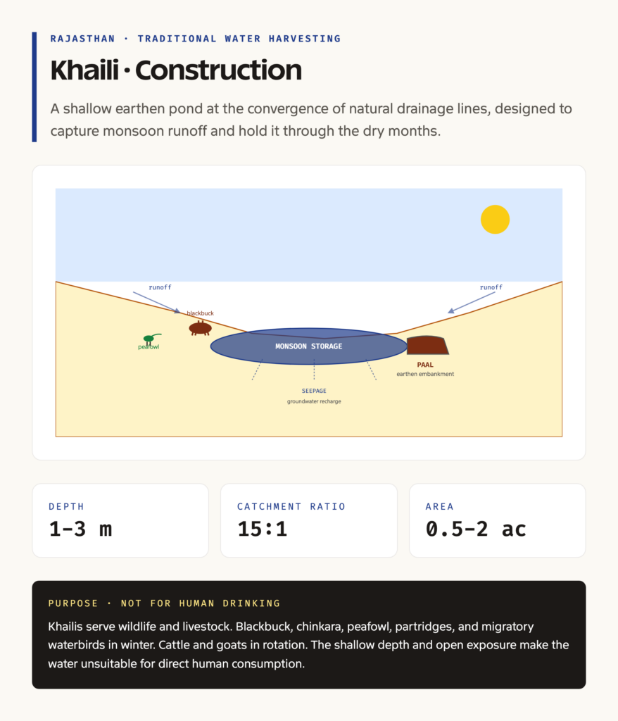
A khaili is a shallow earthen pond, typically formed at the lower end of a natural drainage line in a village’s pasture or common land. Its construction is simple. Villagers excavate a depression, usually elliptical, with a depth of one to three metres. The excavated earth is used to build a low embankment, or paal, on the downstream side, which retains the water. The base and sides are lightly puddled with clay to reduce seepage but never sealed entirely, because some seepage is desired for groundwater recharge.
The structure is small. A typical khaili is between half an acre and a couple of acres in surface area. It captures runoff from the surrounding catchment during the monsoon and holds the water through the post-monsoon and winter, drying down progressively during the hot dry season. By April or May, most khailis are dry, and they are then desilted in May and June ahead of the next monsoon.
The water in a khaili is not used for human drinking. The shallow depth, the open exposure to dust and wildlife, and the seasonal evaporation make it unsuitable for direct human use. Instead, the khaili functions as a water point for wildlife and livestock. Blackbuck, chinkara, and other ungulates visit during the dry season. Peafowl, partridges, and migratory waterbirds use the pond during winter. Cattle and goats from the village graze and drink in rotation. The khaili thus operates as a shared, multi-species water resource at the village level.
Background and Historical Context
The khaili system has deep historical roots in arid Rajasthan, although it lacks the formal documentation of larger structures like the talab or the johad. References in Marwar revenue records, in nineteenth-century British district gazetteers, and in oral histories of village communities indicate that khailis were a normal part of the village commons. The water pricing system in princely Marwar gave specific recognition to wells, tanks, and ponds, and the khaili was treated as a community resource subject to customary management.
The decline came through the twentieth century. Several pressures combined. Tube-well irrigation, expanding from the 1960s, lowered the water table and reduced the catchment yield to surface ponds. Land use change, with conversion of pasture commons to private agriculture, eroded the physical space for khailis. Political restructuring of village commons under the panchayati raj system, although well-intentioned, often loosened the customary management of pond resources. By the 1990s, many khailis had silted up, been encroached, or been abandoned.
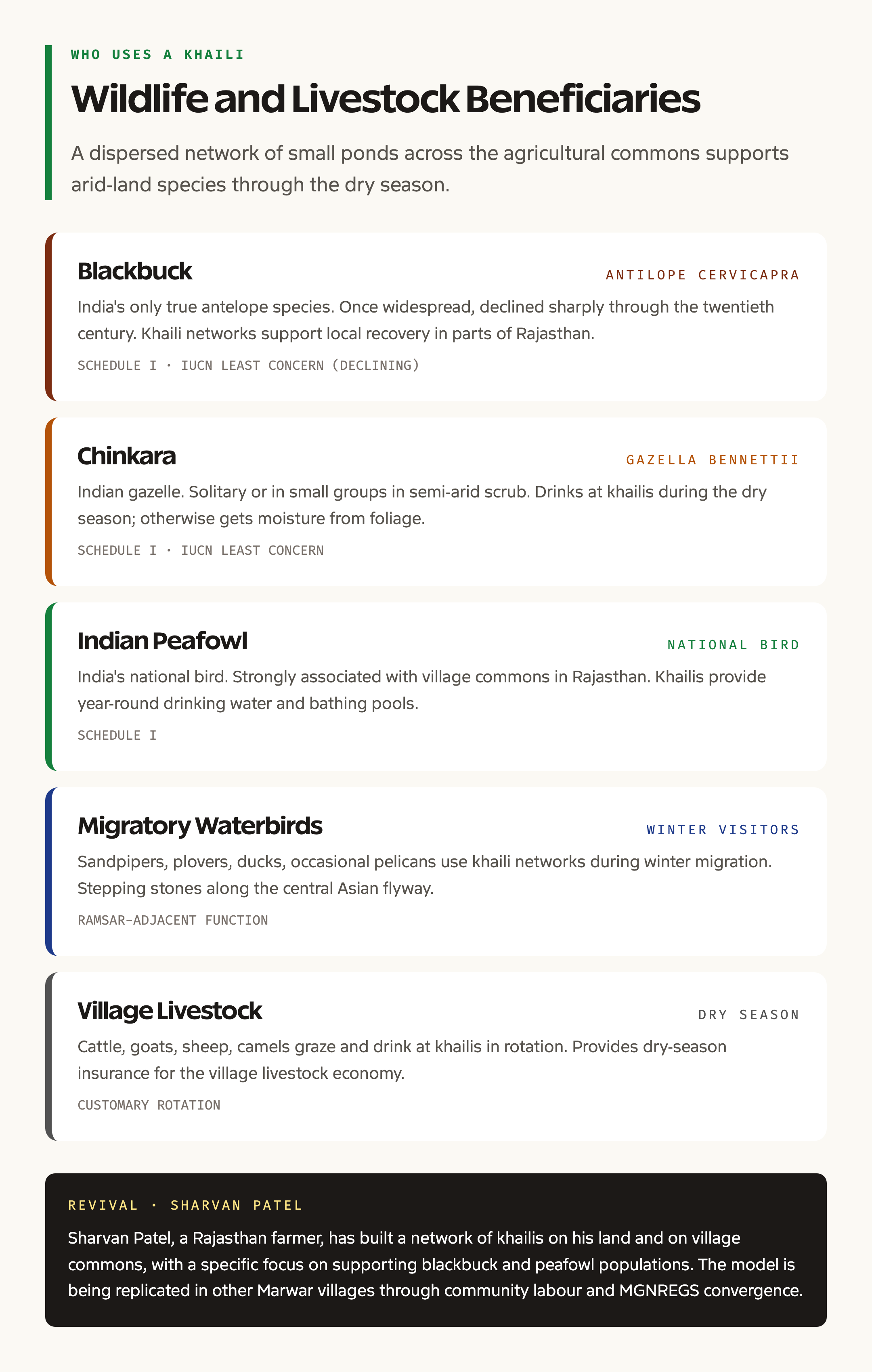
The recent revival is associated with individual conservationists and community institutions. Sharvan Patel, a farmer in Rajasthan, has built a network of khailis on his land and on village commons, with a specific focus on supporting blackbuck and peafowl populations. Reports from publications like The Better India have documented the revival, and the model has begun to be replicated in other Marwar villages.
The revival sits within a broader policy framework. State watershed programmes, the Mahatma Gandhi National Rural Employment Guarantee Scheme (MGNREGS), and the Jal Shakti Abhiyan have all supported small water harvesting structures, with khailis qualifying as an eligible category. The intersection with environmental laws in India and biodiversity in India frameworks has reinforced the wildlife dimension.
Construction, Maintenance, and Hydrology
A well-built khaili draws on traditional engineering knowledge. The siting is critical. The pond is placed at the convergence of two or more natural drainage lines, in a location where the catchment area is at least 10 to 20 times the pond surface area. The soil must be predominantly clay or clay-loam to retain water; sandy soils are unsuitable without import of clay material.
Construction begins in May, before the monsoon. Villagers excavate the depression with manual labour, animal-drawn scrapers, or, in modern revivals, with light machinery. The excavated material is compacted into the embankment, with a base width several times the height to ensure stability. The inlet is left open or fitted with a low spillway to allow excess water to overflow without damaging the embankment.
Hydrologically, the khaili functions through a combination of direct precipitation, surface runoff capture, and limited subsurface seepage into the local water table. The catchment-to-pond area ratio determines how reliably the pond fills in a given monsoon. Studies of similar structures in the region suggest that a ratio of 15:1 typically produces a reliable yield in years of normal rainfall (above 350 mm) and a reduced yield in drought years.
Maintenance is annual and labour-intensive. Desilting before each monsoon removes the previous year’s sediment load and restores capacity. The embankment is checked for breaches and rebuilt where needed. The clay puddling is renewed in patches that have eroded. In modern revivals, social labour is sometimes supplemented by MGNREGS work, with the pond serving as both a wildlife resource and a wage employment site.
Why Khailis Matter
The case for khailis operates at several levels. Ecologically, they create dispersed water points across the arid agricultural landscape, reducing wildlife concentration around scarce permanent water sources and allowing populations of blackbuck, chinkara, peafowl, and other species to maintain higher numbers than would otherwise be possible. The 2010s and 2020s have seen modest recovery of some of these species in parts of Rajasthan, attributed in part to the dispersed water network.
Hydrologically, khailis contribute to local groundwater recharge. The seepage through the bed and sides of the pond, although not large in absolute terms, accumulates over many ponds across a village landscape and contributes to the shallow water table. In parts of Rajasthan where the deep aquifer is fossil and non-renewable, the shallow recharge from surface ponds is critical.
Culturally, the khaili sits at the intersection of village commons, customary management, and traditional ecological knowledge. The revival of khailis is not just an engineering project but a re-articulation of community responsibility for shared resources. The principle of village commons, eroded over the twentieth century, finds practical expression in pond maintenance, grazing rotations, and ritual observance.
Economically, the khaili supports the village livestock economy by providing dry-season water for cattle, goats, and sheep. In a region where the livestock-crop mix is the foundation of rural livelihood, this dry-season insurance is significant.
Detailed Analysis: A Comparative Map of Indian Traditional Water Harvesting
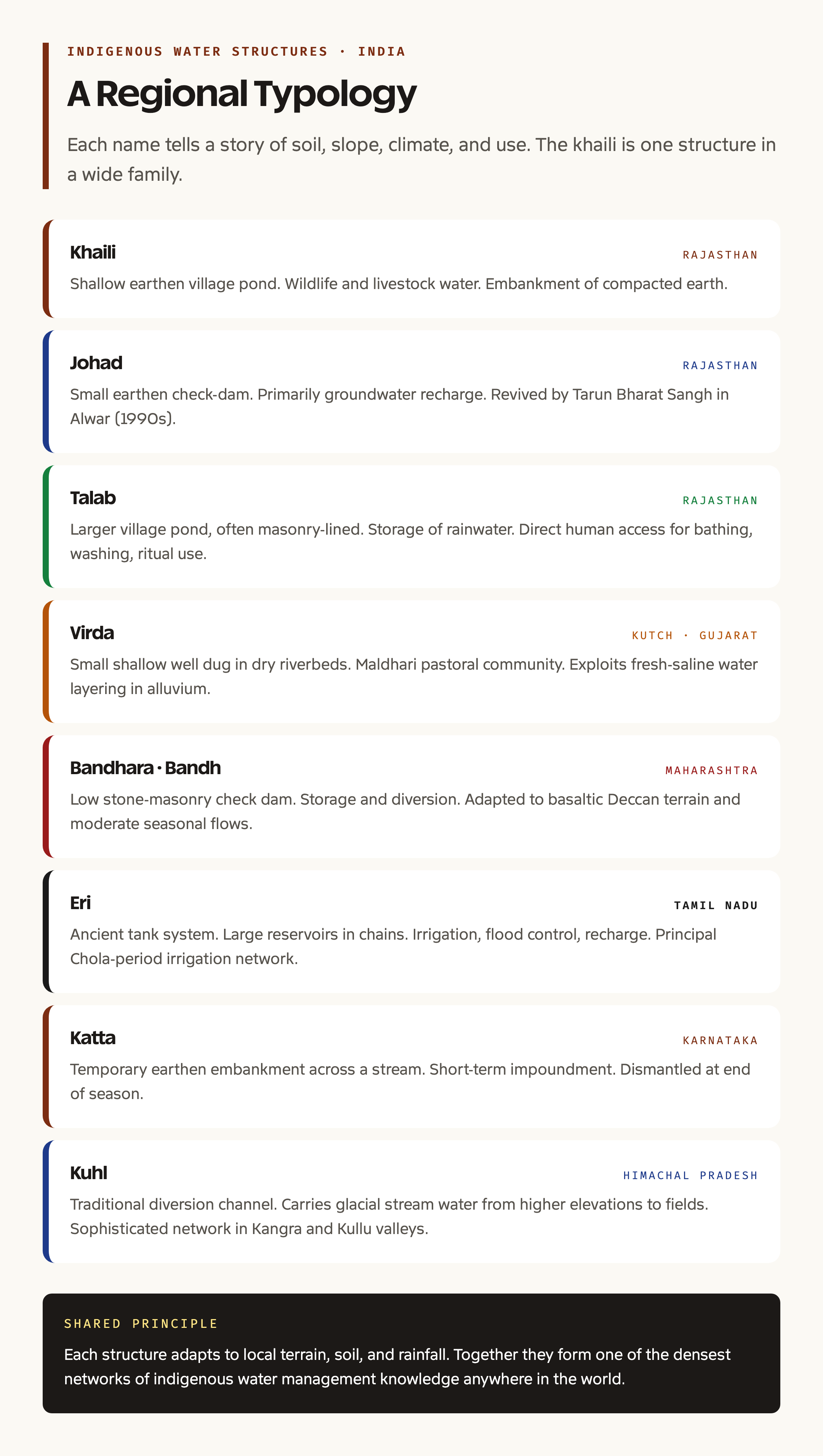
India’s traditional water harvesting structures form a typological family, each adapted to terrain, soil, climate, and use. The khaili sits within this family alongside several related structures.
The johad is also from Rajasthan, particularly the Aravalli foothills. It is a small earthen check-dam used primarily for groundwater recharge, with a pond formed behind the dam during and after the monsoon. The Tarun Bharat Sangh’s revival of johads in Alwar district under Rajendra Singh, the “Waterman of India”, drew global attention in the 1990s and 2000s.
The talab is a larger village pond, often masonry-lined or partially stone-built, used for storage of rainwater and for direct human access for bathing, washing, and ritual use. The talab is typically more durable, more central to village life, and more formally maintained than the khaili.
The virda is from Kutch in Gujarat. It is a small, shallow well dug in the dry bed of a seasonal river to collect seepage water during the dry season. The Maldhari pastoral communities have used virdas for centuries, drawing on the salt-water and fresh-water layering in the alluvial sediments.
The bandhara or bandh is from Maharashtra’s Deccan plateau. It is a low stone-masonry check dam used to store water and divert it for irrigation. The structures are designed for the basaltic terrain and the moderate seasonal flows of the Western Ghats and Deccan.
The eri is the ancient tank system of Tamil Nadu. Eris are large reservoirs, sometimes covering hundreds of acres, fed by chains of smaller feeder tanks and used for irrigation, flood control, and groundwater recharge. The Tamil Nadu eri network was the principal irrigation infrastructure of the medieval Chola period.
The katta is from Karnataka. It is a temporary earthen embankment built across a stream to impound runoff for short-term use, typically dismantled at the end of the season. It is the simplest of the structures in this family.
The kuhl is from Himachal Pradesh. It is a traditional diversion channel that carries glacial stream water from the higher elevations to fields lower down. The kuhl network in the Kangra and Kullu valleys is one of the more sophisticated traditional irrigation systems in the Himalayan region.
These structures, taken together, demonstrate the depth and diversity of indigenous water management knowledge across the Indian subcontinent.
Comparative Perspective
Internationally, the khaili invites comparison with structures like the qanat of Persia, the tinajas of the American Southwest, the cisternas of the Mediterranean, and the ahar-pyne system of southern Bihar. Each represents a regional adaptation to seasonal water availability and terrain.
The closer comparison, however, is within India itself. The khaili sits at the smaller, more dispersed end of the traditional water harvesting spectrum, distinguished from the talab by its smaller size and wildlife focus, from the johad by its absence of a formal check dam structure, and from the eri by its scale and use pattern. The diversity of names and types underscores the regional specificity of indigenous water management.
Challenges and Issues
The revival of khailis faces a clutch of challenges. Land tenure is the first. Many khailis sit on village commons that are under pressure from encroachment, conversion to private agriculture, or institutional redesignation. The Forest Rights Act, 2006, and the customary common rights frameworks intersect in complex ways, and the legal protection of khaili sites remains uneven.
Maintenance economics is the second. Annual desilting and embankment repair require labour, and the community institutions that historically organised this labour have weakened. MGNREGS convergence offers a route, but the bureaucratic process can be slow and the work-priority lists do not always include khailis.
Pollution and contamination is the third. Modern agricultural runoff, including pesticide residues, can affect the water quality in khailis. The wildlife use of the ponds means that contamination has direct ecological consequences. Buffer protections and pesticide-management protocols are needed but are rarely in place.
Climate variability is the fourth and largest. Rajasthan’s monsoon has shown increasing variability over recent decades, with more intense but less frequent rainfall events. Khailis designed for the older rainfall pattern may need redesigning, with larger storage capacity or higher embankments, to handle the new regime.
Prelims Pointers
- Region: Rajasthan (Marwar, Shekhawati).
- Type: Shallow earthen village pond.
- Material: Earth and clay.
- Source: Monsoon runoff.
- Use: Water for wildlife and livestock, not human drinking.
- Key species: Blackbuck, chinkara, peafowl.
- Notable revival: Sharvan Patel network.
- Comparison structures: Johad (Rajasthan, recharge), Talab (Rajasthan, storage), Virda (Kutch, dry-bed wells), Bandhara (Maharashtra, check dam), Eri (Tamil Nadu, tank system), Katta (Karnataka, temporary bund), Kuhl (Himachal, diversion channel).
- Maintenance: Annual desilting before monsoon.
- Policy convergence: State watershed, MGNREGS, Jal Shakti Abhiyan.
- Tarun Bharat Sangh / Rajendra Singh: Johad revival in Alwar (1990s-2000s).
- Cultural role: Village commons, customary management.
Probable Mains Questions
- Discuss the role of traditional water harvesting structures in addressing water scarcity in arid India, with reference to khailis, johads, and virdas. (250 words)
- The revival of indigenous water management practices is relevant to both wildlife conservation and rural livelihoods. Examine. (250 words)
- Discuss the institutional frameworks needed to scale up traditional water harvesting in contemporary India. (150 words)
Way Forward
The khaili revival, and traditional water harvesting more broadly, needs interventions on several fronts. Recognition in planning is the foundational requirement. State watershed programmes, MGNREGS work plans, and district irrigation plans should explicitly recognise khailis as a category, with technical specifications, cost norms, and monitoring protocols.
Community institution strengthening must accompany physical revival. Pani panchayats, village watershed committees, and customary management bodies need legal recognition, training, and ongoing support to maintain ponds across years and across leadership changes.
Wildlife coordination through state forest departments and the BNHS network can ensure that khaili siting and management considers the corridor and habitat needs of arid-land species. Mapping of existing and potential khaili networks, paired with blackbuck and chinkara population data, would generate priority sites for revival.
MGNREGS convergence offers a fiscal route. Village pond construction and desilting are eligible categories, and rural employment guarantee work can be channelled through this stream. The convergence requires panchayat-level technical capacity that is uneven across the state.
Knowledge documentation of traditional design, customary management, and indigenous engineering knowledge is urgent. Many of the elders who carry this knowledge are ageing, and the documentation effort, partly carried by NGOs and academic researchers, needs greater institutional support. The combined frameworks of biosphere reserves in India and the tiger reserves in India network can provide partial models for community-based resource management.
Frequently Asked Questions
What is a khaili?
A khaili is a traditional shallow village pond in Rajasthan, formed by lightly excavating a depression and bunding it on one side with earth and clay. It captures monsoon runoff and holds the water through the dry months. The water is for wildlife and livestock use, not for human drinking.
Where are khailis found in India?
Khailis are found primarily in Rajasthan, particularly in the Marwar and Shekhawati belts of the western and northern parts of the state. Similar structures exist in other arid parts of India under different local names.
How is a khaili built?
A khaili is built by excavating a shallow depression, usually one to three metres deep and half an acre to a couple of acres in surface area, at the convergence of natural drainage lines. The excavated earth is compacted into a low embankment on the downstream side, and the base and sides are lightly puddled with clay to retain water while allowing limited groundwater recharge.
What is the purpose of a khaili?
The primary purpose is to provide a dispersed network of water points across the arid agricultural landscape. Wildlife species such as blackbuck, chinkara, peafowl, and partridges use khailis during the dry season, and village livestock graze and drink at them in rotation. Khailis also contribute to local groundwater recharge.
How is a khaili different from a johad?
A johad is a small earthen check-dam used primarily for groundwater recharge, with a pond formed behind the dam. A khaili is a shallower, smaller pond without a formal dam structure, designed primarily for wildlife and livestock water rather than recharge. Both are from Rajasthan but serve different functions.
Who is Sharvan Patel and what is his connection to khailis?
Sharvan Patel is a Rajasthan farmer who has built a network of khailis on his land and on village commons. His work, focused on supporting blackbuck and peafowl populations, has drawn media attention through publications like The Better India and has helped revive the khaili tradition in parts of Rajasthan.
How does a khaili compare with a virda from Kutch?
A virda is a small, shallow well dug in the dry bed of a seasonal river in Kutch, Gujarat, designed to collect seepage water by exploiting the layering of fresh and saline water in the alluvial sediments. A khaili is a surface pond rather than a well. Both are arid-land traditional structures but use different hydrological principles.
Why have khailis declined in number?
Khailis declined through the twentieth century due to the expansion of tube-well irrigation, the conversion of pasture commons to private agriculture, the loosening of customary management under panchayati raj restructuring, and the general neglect of small water harvesting structures in modern planning frameworks.
What is the role of MGNREGS in khaili revival?
The Mahatma Gandhi National Rural Employment Guarantee Scheme (MGNREGS) supports water harvesting structures, including khailis, as eligible categories of work. Rural employment guarantee labour can be channelled through this stream for pond construction and annual desilting, although the bureaucratic process can be slow and uneven.
Is the khaili part of any official conservation framework?
The khaili is recognised in state watershed programmes, MGNREGS work guidelines, and the Jal Shakti Abhiyan. It is not subject to a dedicated central scheme but benefits from convergence across these frameworks. The wildlife dimension intersects with state forest department programmes and customary common-property frameworks at the village level.
Tell Google you want more of this.
Add Anantam IAS as a preferred sourceOne tap, and this site shows up more often in your own Top Stories, AI Overviews and AI Mode. Remove it any time.