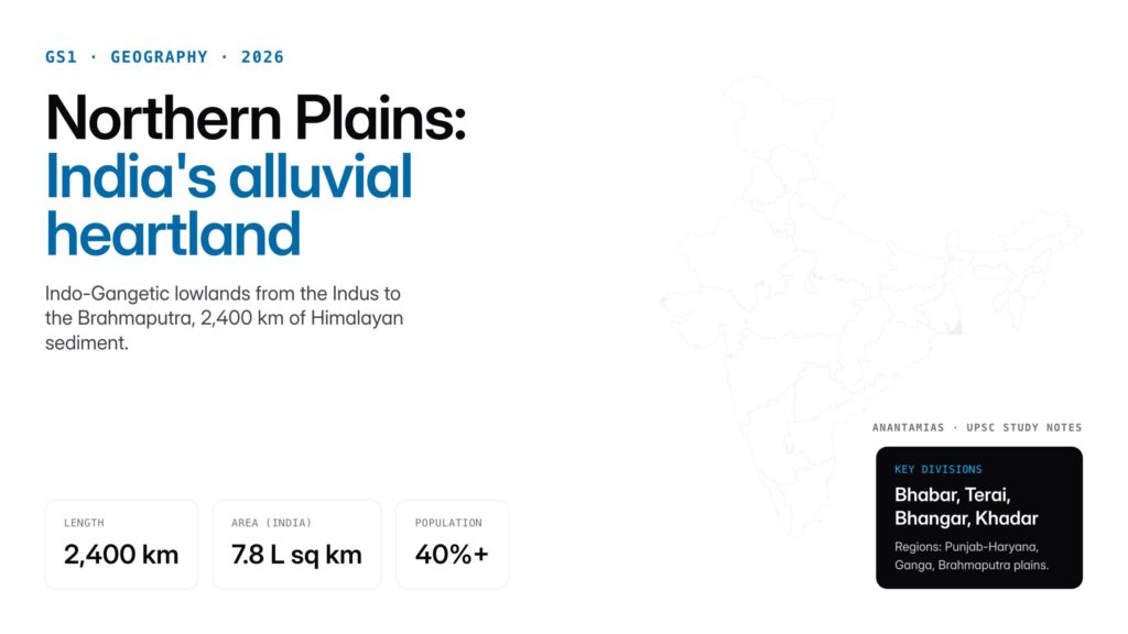
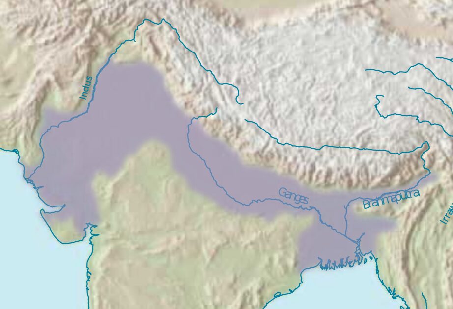
The Northern Plains of India are a vast, densely populated belt of alluvial lowland stretching roughly 2,400 km east–west between the Himalayas and the Peninsular plateau, covering about 7.8 lakh sq km. Built up over millions of years from sediment carried down by the Indus, Ganga and Brahmaputra river systems, they are divided north-to-south into four relief belts — bhabar, terai, bhangar and khadar — and west-to-east into the Punjab–Haryana, Ganga and Brahmaputra plains. Home to more than 40% of India’s people, they are the country’s agricultural heartland and the cradle of its earliest civilisations.
Introduction
The Northern Plains of India are one of the world’s most extensive stretches of alluvial lowlands, running east-west for about 2,400 kilometres between the Himalayas in the north and the peninsular plateau in the south. Formed by the deposition of sediments brought down by the Indus, Ganga, Brahmaputra and their tributaries, these plains extend across parts of Pakistan, India, Nepal and Bangladesh, with the Indian section alone covering roughly 7.8 lakh square kilometres. From a physical geography standpoint, the Northern Plains are a textbook example of a foreland basin filled with Quaternary sediments; from a human geography standpoint, they support over forty percent of India’s population on a fraction of its land area.
For UPSC aspirants, the Northern Plains are core GS1 geography. Prelims questions probe the four divisions (bhabar, terai, bhangar, khadar), the relief subdivisions (Punjab plain, Ganga plain, Brahmaputra plain), the formation theory, the doabs, and the soil types. Mains essays on food security, groundwater depletion, flood management, and the river-linking debate all anchor themselves in the Northern Plains. Understanding their geology, hydrology, and economic significance gives aspirants a durable framework across physical, human and economic geography.
Quick Facts at a Glance
| Attribute | Detail |
|---|---|
| East-west length | About 2,400 km |
| North-south width | 150-300 km (widest in west, narrowest in Assam) |
| Area (Indian section) | About 7.8 lakh sq km |
| Average elevation | 200 m or less above mean sea level |
| Formation | Foreland basin filled by Indus-Ganga-Brahmaputra sediments, Pleistocene to Holocene |
| Major rivers | Indus, Sutlej, Ganga, Yamuna, Ghaghara, Gandak, Kosi, Brahmaputra |
| Key divisions (relief) | Bhabar, Terai, Bhangar, Khadar |
| Regional divisions | Punjab-Haryana plain, Ganga plain, Brahmaputra plain |
| Population density | Highest in India; Bihar over 1,100 per sq km |
| Main soils | Alluvial (khadar and bhangar) |
| Cropping pattern | Wheat-rice, sugarcane, jute, pulses, oilseeds |
Background and Historical Context
The Northern Plains formed during the collision of the Indian and Eurasian plates that raised the Himalayas. As the Himalayas rose, a large foreland tectonic trough developed in front of the mountains. Over the Tertiary and Quaternary periods, this trough was filled progressively by sediments eroded from the rising Himalayas and transported by rivers. Geological estimates place the sediment thickness at over 2,000 metres in many places, reaching up to 6,000 metres in parts of the Punjab-Haryana plain. The plains are therefore relatively young in geological terms, formed largely over the last 10 million years.
The plains have been the cradle of Indian civilisation since the Bronze Age. The Indus Valley civilisation flourished on the western plains around 2500-1900 BCE. The Vedic civilisation, the Mahajanapadas of the first millennium BCE, the Mauryan and Gupta empires, the Delhi Sultanate, the Mughals and British India all had their political heartlands in the Gangetic plain. The flat, fertile and well-watered terrain favoured agricultural settlement, permitted the rise of large cities, and allowed administrative integration across vast distances. Modern India’s four most populous states (Uttar Pradesh, Bihar, West Bengal and Madhya Pradesh) either lie entirely or substantially within the Northern Plains.
Key Features and Divisions
Relief Subdivisions (north to south)
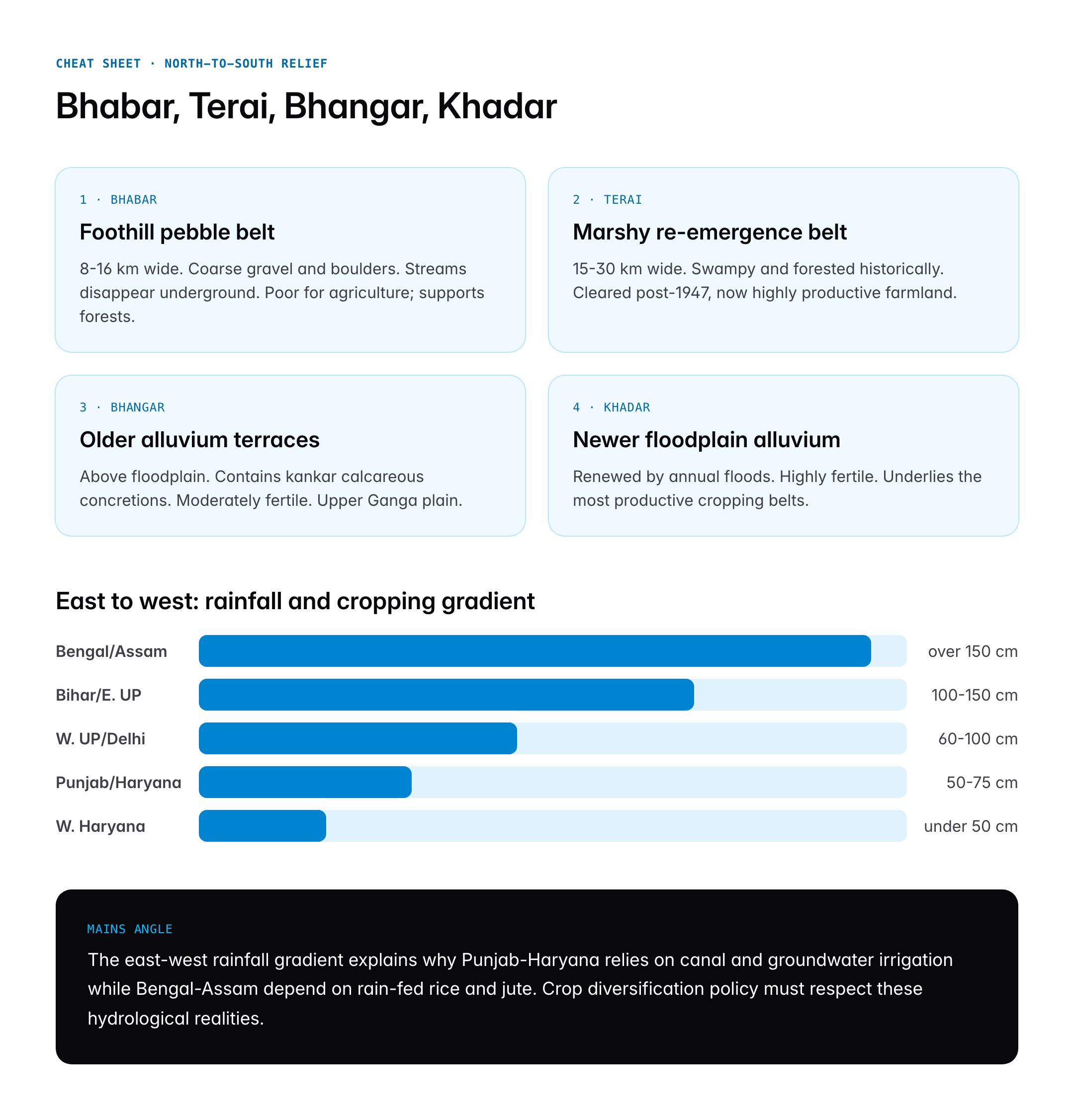
Bhabar is the narrow belt, eight to sixteen kilometres wide, lying along the foothills of the Himalayas from the Indus in the west to the Tista in the east. Composed of coarse pebbles, gravel and boulders deposited by rivers emerging from the mountains, the bhabar is highly porous. Streams disappear underground on entering it and re-emerge further south. The belt is unsuitable for agriculture but supports forests and orchards.
Terai is a marshy tract, fifteen to thirty kilometres wide, lying south of the bhabar. Underground streams of the bhabar re-emerge here, creating swampy, forested land. Historically malaria-infested, the terai was systematically cleared after Independence and has become highly productive farmland in Uttarakhand, northern Uttar Pradesh, Bihar and West Bengal.
Bhangar is the older alluvium that forms terraces above the present floodplain. It contains calcareous concretions called kankar and is less fertile than newer alluvium, though still agriculturally important. Bhangar is more extensive in the upper Ganga plain.
Khadar is the newer alluvium deposited in the floodplains, renewed each year by floods. It is highly fertile and supports intensive agriculture. Khadar soils underlie the most productive cropping belts of Punjab, Haryana and western Uttar Pradesh.
Regional Subdivisions (west to east)
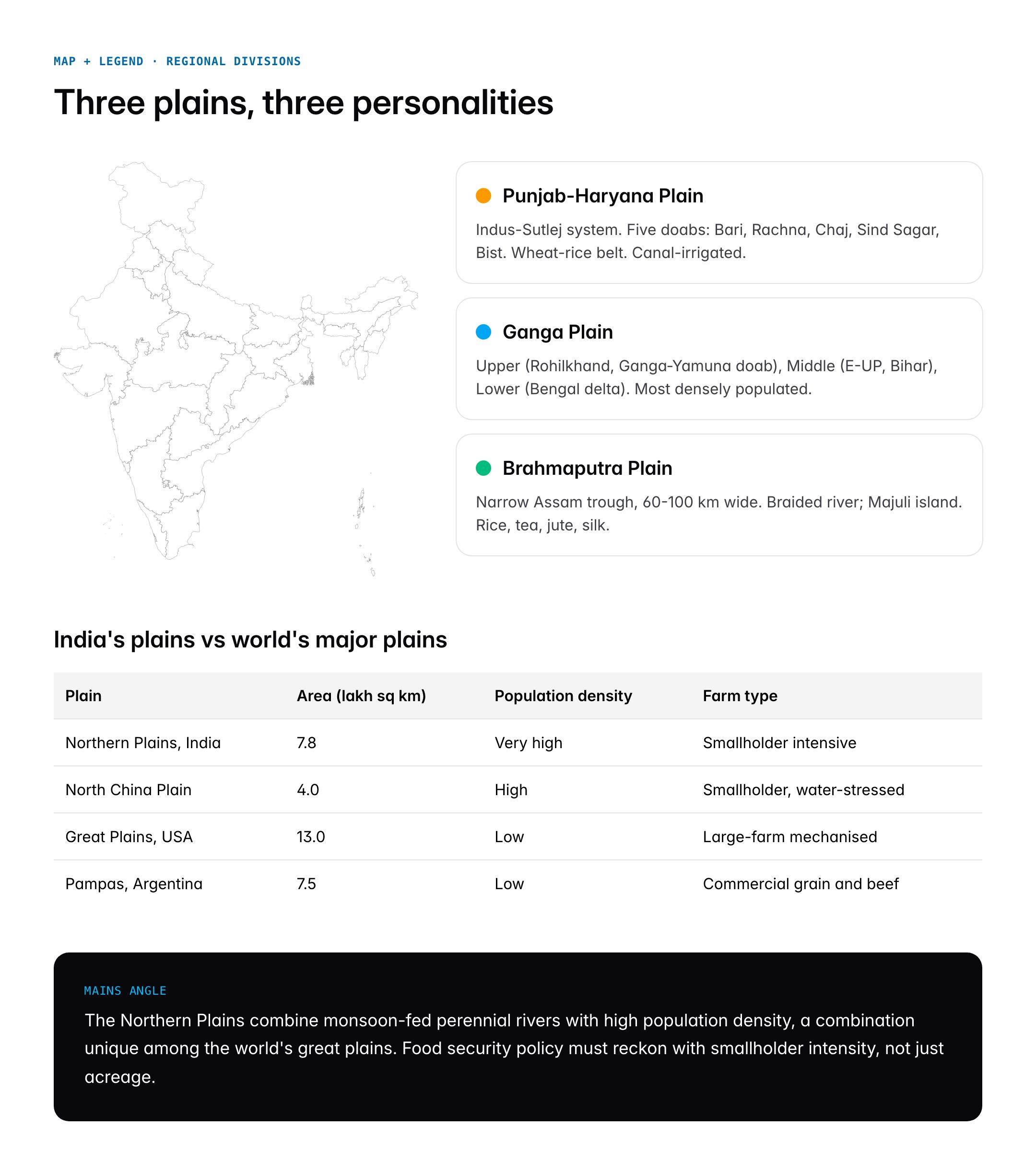
The Punjab-Haryana plain is formed by the Indus and its five tributaries, the Jhelum, Chenab, Ravi, Beas and Sutlej. The land between two rivers is called a doab. The five doabs are the Bari Doab, Rachna Doab, Chaj Doab, Sind Sagar Doab and Bist Doab. The plain features bhur (aeolian sand mounds), bet (lowlands) and khols (ravines). Intensive canal irrigation has made this region the granary of India.
The Ganga plain stretches from the Yamuna in the west to Bangladesh in the east, covering over 3.75 lakh square kilometres in India. It is subdivided into the Upper Ganga plain (Rohilkhand, Ganga-Yamuna doab), the Middle Ganga plain (eastern Uttar Pradesh and Bihar) and the Lower Ganga plain (West Bengal, extending to the Sundarbans). The plain is famous for its doabs, dhaya (ravine country along the Chambal), and delta features.
The Brahmaputra plain is a narrow trough, about 60-100 kilometres wide, lying between the Himalayas and the Meghalaya plateau in Assam. The Brahmaputra is a braided river with many river islands including Majuli, historically the world’s largest riverine island. Seasonal flooding is severe.
Doabs
The doab system is distinctive to the Northern Plains. Key Indian doabs include Ganga-Yamuna doab (between the two rivers in Uttar Pradesh), Bari Doab (Beas-Ravi), Bist Doab (Sutlej-Beas), and the lands between Ganga and Ghaghara, Ghaghara and Gandak, Gandak and Kosi. Each doab historically formed a distinct cultural-agricultural unit.
Soils and Hydrology
Alluvial soils dominate, with texture varying from sandy in the bhabar to clayey in the khadar. The plains are underlain by one of the largest groundwater systems in the world. Rainfall declines from east (over 150 cm in Bengal) to west (under 50 cm in western Haryana), driving sharp gradients in cropping patterns and irrigation reliance.
Significance for UPSC and General Knowledge
- Core GS1 physical geography topic: formation from Himalayan collision, alluvial deposition, and sub-surface structure.
- Provides the setting for GS1 human geography: population density, urbanisation, migration patterns in UP, Bihar and Bengal.
- Central to GS3 discussions on food security: the Green Revolution belt of Punjab-Haryana, rice-wheat cropping systems, and the need for crop diversification.
- Relevant to environment and disaster management: annual Kosi and Brahmaputra floods, groundwater depletion across Punjab and Haryana, and declining soil health under intensive agriculture.
- Historical geography significance: cradle of Indus Valley, Vedic and Gangetic civilisations; shaping of Indian polity and culture.
- Contemporary policy links: river linking projects, National Mission for Clean Ganga, aquifer mapping under Atal Bhujal Yojana, and farm-law debates.
Detailed Analysis: State-wise Distribution and Economic Importance
The Northern Plains span eleven Indian states and union territories. The Punjab-Haryana plain covers Punjab, Haryana, Delhi, parts of Rajasthan (Ganganagar, Hanumangarh), and the Chandigarh Union Territory. Though only about twelve percent of India’s area, this sub-region contributes a disproportionate share of national wheat and rice procurement for the Public Distribution System, often over forty percent in some years. Intensive canal irrigation from the Bhakra-Nangal, Indira Gandhi Canal and Yamuna systems underpins this productivity.
The Upper Ganga plain in western and central Uttar Pradesh is dominated by sugarcane (Muzaffarnagar, Meerut belt), rice, wheat and pulses. The Ganga-Yamuna doab is historically among India’s most densely populated agricultural belts. The Middle Ganga plain in eastern UP and Bihar faces challenges: fragmented land holdings, low productivity, and recurring floods from the Kosi (the “Sorrow of Bihar”) and Ghaghara. Yet it remains a critical rice-producing region with vast labour reserves.
The Lower Ganga plain in West Bengal is dominated by rice, jute and fishery in the delta. The Sundarbans, the world’s largest mangrove system, forms its southern terminus. The Brahmaputra plain of Assam specialises in rice, tea, silk and jute, with oil resources around Digboi and Bongaigaon.
Economic activity in the plains extends well beyond agriculture. Over sixty percent of India’s urban population in the top 50 cities lies within the Northern Plains, including Delhi NCR, Kanpur, Lucknow, Patna, Kolkata and Guwahati. Manufacturing is concentrated in the Delhi-NCR and the Kolkata industrial region. The plains host the Golden Quadrilateral’s eastern and northern spines, the Eastern and Western Dedicated Freight Corridors, and a dense railway network. Power generation, from Singrauli’s thermal complex to the upcoming Bihar nuclear projects, anchors much of India’s energy grid.
The population pressure on the plains is immense. According to Census 2011, Bihar’s density stood at 1,102 per square kilometre and West Bengal’s at 1,028, against a national average of 382. Uttar Pradesh is home to over 240 million people, or roughly one in six Indians. This concentration creates both economic opportunity and severe stress on water, land and infrastructure.
Comparative Perspective
A comparison with other major plains regions helps anchor the Northern Plains’ distinctiveness.
| Plain | Country | Area (sq km) | Main Rivers | Key Crops |
|---|---|---|---|---|
| Northern Plains of India | India | 7.8 lakh | Indus, Ganga, Brahmaputra | Wheat, rice, sugarcane, jute |
| North China Plain | China | 4.0 lakh | Huang He, Huai | Wheat, maize, cotton |
| Great Plains | USA | 13.0 lakh | Missouri, Platte | Wheat, maize, soyabean |
| Pampas | Argentina | 7.5 lakh | Parana, Rio de la Plata | Wheat, soyabean, beef |
| Russian Plain | Russia | 40.0 lakh | Volga, Don, Dnieper | Wheat, rye, potatoes |
The Northern Plains are unique in combining a narrow latitudinal width with exceptional population density, and in being fed by rivers that originate in the world’s highest mountains. Unlike the Great Plains or the Pampas, which have low populations and highly mechanised large-farm agriculture, the Indian plains host intensive smallholder agriculture on small and fragmented plots. Unlike the North China Plain, which suffers from chronic water shortage, the Indian plains enjoy the Ganga-Brahmaputra monsoon bounty and the largest perennial river system in the tropics.
Challenges and Criticisms
The Northern Plains face multiple environmental and developmental stresses. Groundwater depletion is severe in Punjab, Haryana and western UP, where water tables are falling by one to two metres per year under paddy-wheat rotations. The Central Ground Water Board categorises over eighty percent of Punjab’s blocks as “over-exploited”, “critical” or “semi-critical”. The Atal Bhujal Yojana, launched in 2019, targets participatory aquifer management in these states.
Flood vulnerability is acute in Bihar, Assam and Bengal. The Kosi shifts its course by up to 100 km, repeatedly inundating millions of acres. The Brahmaputra’s annual floods cause erosion that has shrunk Majuli island by over half since the 1950s. Long-term solutions involve embankments, upstream afforestation, and regional cooperation with Nepal and China.
Soil health decline under monoculture, heavy fertiliser use and stubble burning (in Punjab-Haryana) has pushed down micronutrient content and raised nitrogen runoff. The National Mission for Sustainable Agriculture and PM PRANAM scheme (2023) respond to these concerns.
Other pressures include air pollution in the Indo-Gangetic plain, with the Delhi-Kanpur-Lucknow corridor consistently among the world’s worst by PM 2.5 measures, unplanned urbanisation, shrinking farmland due to city expansion, and social inequalities that persist despite the plains’ economic weight.
Prelims Pointers
- The Northern Plains extend about 2,400 km east-west.
- Formed as a foreland basin filled with alluvium from the Indus-Ganga-Brahmaputra system.
- The four relief subdivisions from north to south are Bhabar, Terai, Bhangar and Khadar.
- Kankar (calcareous concretions) is typical of bhangar soils.
- The land between two rivers is called a doab; the Ganga-Yamuna doab is the most famous.
- Punjab’s five doabs are Bari, Rachna, Chaj, Sind Sagar and Bist.
- Majuli in the Brahmaputra is among the largest river islands in the world.
- The Kosi river is known as the “Sorrow of Bihar” for its frequent course changes.
- The plains host over 40 percent of India’s population on about 24 percent of the land area.
- Census 2011 density: Bihar 1,102, West Bengal 1,028 per sq km; national 382.
- Indira Gandhi Canal is the world’s longest canal system, irrigating parts of the Punjab-Haryana plain and western Rajasthan.
- The plains receive rainfall ranging from over 150 cm in Bengal to under 50 cm in western Haryana.
Mains Practice Questions
Q1. Examine the role of the Northern Plains in India’s economy and food security. What are the main sustainability challenges, and how can they be addressed?
- Role: granary of India, dense population and markets, industrial and urban concentration.
- Challenges: groundwater depletion, soil health decline, floods, air pollution.
- Way forward: crop diversification, drip and sprinkler irrigation, Atal Bhujal Yojana, integrated river basin management.
Q2. Describe the formation and regional divisions of the Northern Plains. How do their sub-regional differences shape agricultural patterns?
- Formation: foreland basin, alluvial deposition from Himalayan collision over Quaternary.
- Divisions: Punjab-Haryana, Ganga (Upper/Middle/Lower), Brahmaputra; bhabar-terai-bhangar-khadar.
- Agriculture: wheat-rice in Punjab-Haryana, sugarcane-rice-wheat in UP, rice-jute in Bengal, rice-tea in Assam.
Conclusion
The Northern Plains of India are a young, dynamic, densely populated landscape that has shaped Indian civilisation for millennia and continues to anchor the country’s food security, economy and demography today. Their formation from Himalayan sediments, their four-fold relief division of bhabar, terai, bhangar and khadar, their three major regional subdivisions of Punjab-Haryana, Ganga and Brahmaputra plains, and their rich tapestry of doabs, rivers and soils make them a geographical masterpiece.
For UPSC aspirants, mastering the Northern Plains pays rich dividends. The topic recurs across physical, human and economic geography, links directly to current-affairs themes from the Green Revolution to groundwater to flood management, and underpins any serious discussion of India’s development trajectory. A clear mental map of the plains, from the Punjab canal colonies through the Ganga doabs to the Brahmaputra tea gardens, is one of the most useful assets an aspirant can build.
Frequently Asked Questions
What are the Northern Plains of India?
The Northern Plains are a vast alluvial lowland stretching about 2,400 km east-west between the Himalayas and the peninsular plateau. Formed by the deposition of sediments from the Indus, Ganga and Brahmaputra river systems, they cover about 7.8 lakh sq km in India and span parts of Punjab, Haryana, UP, Bihar, Bengal and Assam. They are the most densely populated region of India.
Why are the Northern Plains important for UPSC?
They are core GS1 geography, tested in Prelims through questions on divisions, doabs, soils and rivers, and in Mains through themes of food security, groundwater depletion and flood management. They are also central to GS3 agriculture and environment topics, and provide context for historical geography questions linking the Indus Valley and Gangetic civilisations.
How are the Northern Plains related to the Himalayas?
The plains formed as a foreland basin during the collision of the Indian and Eurasian plates that raised the Himalayas. As the mountains rose, rivers eroded them and deposited sediment in the trough in front. Over the Quaternary period, sediment depth reached 2,000 to 6,000 metres. The Himalayas thus both created the basin and supplied the alluvium that filled it.
What are bhabar, terai, bhangar and khadar?
These are the four north-to-south relief subdivisions. Bhabar is a narrow belt of coarse pebbles at the Himalayan foothills where streams disappear underground. Terai is a marshy tract south of bhabar where streams re-emerge. Bhangar is older alluvium forming terraces with kankar concretions. Khadar is newer floodplain alluvium, renewed by annual floods and highly fertile.
What is a doab and which are the major ones?
A doab is the land between two rivers. The Ganga-Yamuna doab is the most famous, running through western Uttar Pradesh. Punjab has five classic doabs: Bari (Beas-Ravi), Rachna (Chenab-Ravi), Chaj (Jhelum-Chenab), Sind Sagar (Indus-Jhelum) and Bist (Sutlej-Beas). Doabs have historically been distinct cultural and agricultural units with intensive irrigation and settlement.
Why is the Kosi called the Sorrow of Bihar?
The Kosi river, which originates in Nepal and joins the Ganga in Bihar, is known for shifting its course dramatically over time, by as much as 100 km westward over the last two centuries. Its annual floods inundate millions of acres, displace hundreds of thousands of people and destroy crops and infrastructure. Embankments and Indo-Nepal cooperation are the main mitigation efforts.
What are the main agricultural patterns in the plains?
Punjab-Haryana is dominated by the wheat-rice rotation supported by canal irrigation. Western UP grows sugarcane, wheat and pulses. Eastern UP and Bihar focus on rice, pulses and oilseeds. West Bengal specialises in rice and jute, with delta fisheries. Assam’s Brahmaputra plain combines rice, tea, jute and silk. Rainfall gradients from east to west drive much of this differentiation.
What are the biggest environmental challenges?
Groundwater depletion in Punjab, Haryana and western UP, where water tables fall 1-2 metres per year under paddy-wheat rotations; annual floods in Bihar, Assam and Bengal; soil health decline under monoculture and heavy fertiliser use; and severe air pollution in the Indo-Gangetic plain. Policy responses include Atal Bhujal Yojana, PM PRANAM, crop diversification and integrated river basin management.
Tell Google you want more of this.
Add Anantam IAS as a preferred sourceOne tap, and this site shows up more often in your own Top Stories, AI Overviews and AI Mode. Remove it any time.