NVS-01 and NVS-02 are the first two satellites of India’s second-generation Navigation with Indian Constellation, abbreviated NavIC. They were launched in 2023 and 2025 respectively to replace the ageing IRNSS satellites, restore signal availability over the Indian region, and add new civilian and strategic capabilities the original constellation never had. The most important among these is the L1 signal, which makes NavIC compatible with smartphones and consumer chipsets for the first time, and the indigenous Rubidium Atomic Frequency Standard, which fixes the single biggest reliability problem the IRNSS constellation has faced.
For a country that depends on positioning, navigation, and timing for everything from agricultural mandi payments to artillery fire control, owning the entire stack matters. The strategic case for NavIC has never been clearer than after the 2020s saw multiple incidents of GPS spoofing in conflict zones and selective denial of service warnings issued to neighbours. NVS-01 and NVS-02 are the first concrete steps in moving NavIC from a backup system to a primary regional alternative for users inside Indian territory and out to about 1,500 km beyond the borders.
For UPSC GS-III, the topic sits at the intersection of space technology, defence preparedness, and digital infrastructure. This article walks through what NVS-01 and NVS-02 actually do, how they differ from the older IRNSS satellites, the modernised payload, the launch story, and the strategic context.
Quick Facts on NVS-01 and NVS-02
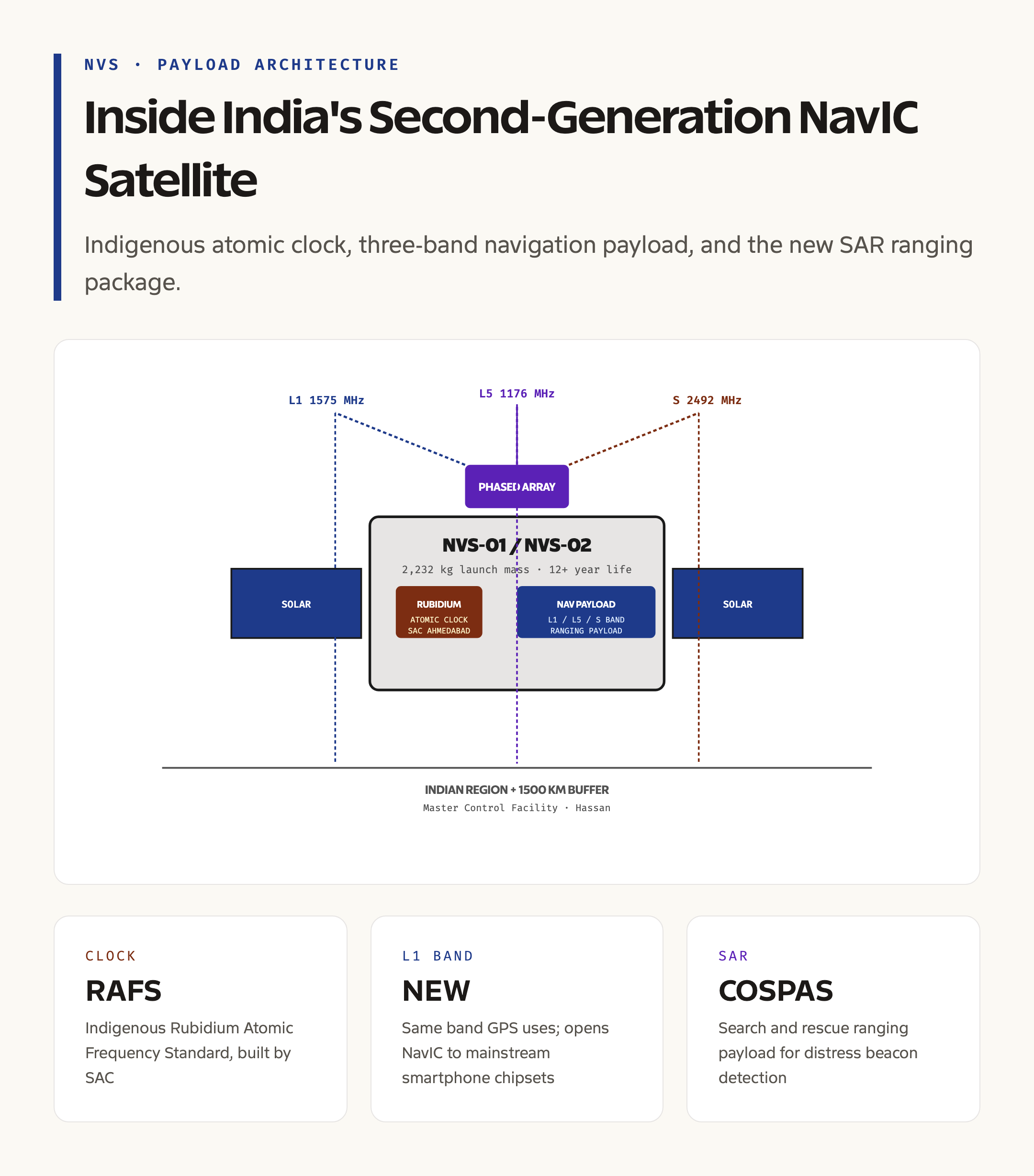
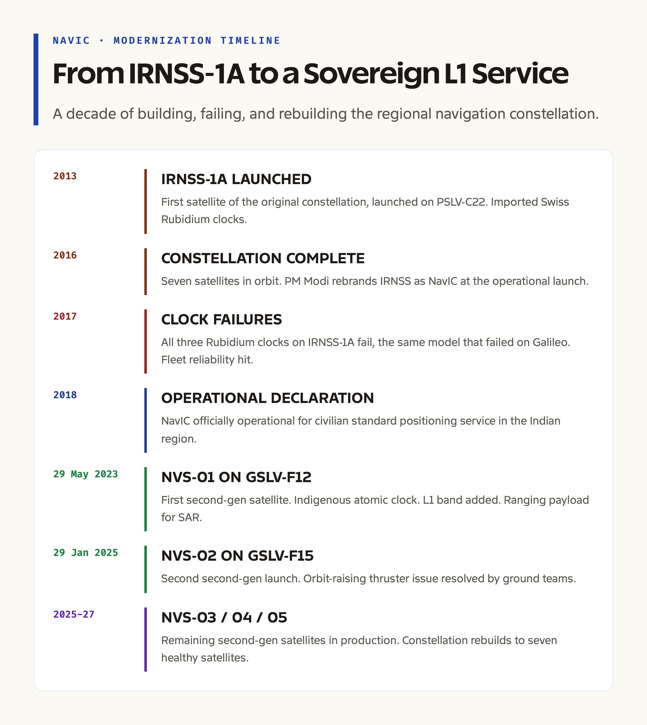
NVS-01, also called NavIC Satellite-01, was launched on 29 May 2023 aboard a GSLV-F12 rocket from the Satish Dhawan Space Centre at Sriharikota. It was placed in a geosynchronous transfer orbit and later raised to its operational geosynchronous slot. NVS-02 followed on 29 January 2025 aboard a GSLV-F15 from the same site, although the satellite faced an initial orbit-raising issue resolved by ground teams in the weeks that followed. Both satellites are built by ISRO and operated from the Master Control Facility at Hassan, Karnataka.
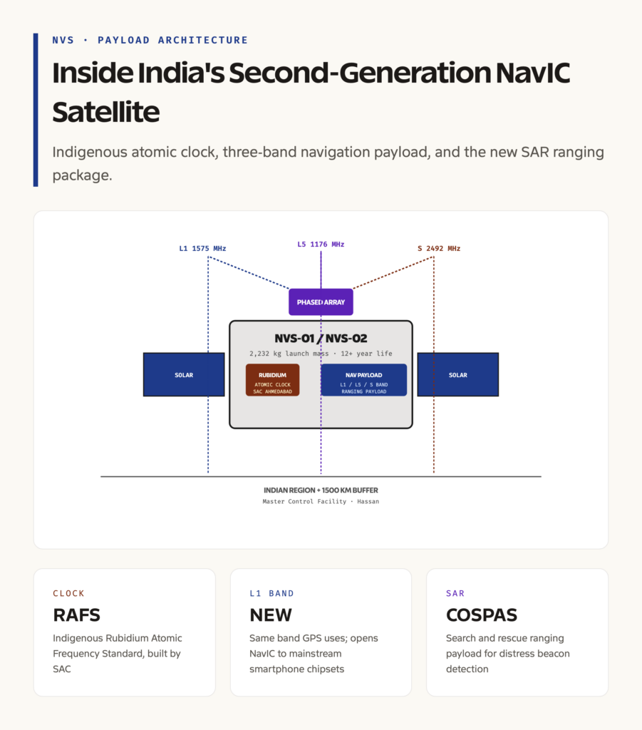
The two satellites are part of an order of five second-generation NavIC satellites, NVS-01 through NVS-05, sanctioned to upgrade the constellation from the original IRNSS-1A through IRNSS-1I generation. They carry navigation payloads operating on L1, L5, and S bands, and a separate ranging payload that supports search and rescue services. The mass at launch is around 2,232 kilogrammes, heavier than the older IRNSS satellites, with a planned operational life of more than 12 years.
The total NavIC constellation as of 2026 includes a mix of legacy IRNSS and new NVS satellites. The target steady-state configuration is seven operational satellites, with three in geostationary orbit and four in inclined geosynchronous orbits.
Why the Second-Generation NavIC Was Needed
The original IRNSS constellation, branded NavIC after it became operational in 2018, was built between 2013 and 2018. It had three persistent problems. The first was the failure of multiple atomic clocks. IRNSS-1A, the first satellite, lost all three of its imported Rubidium Atomic Frequency Standards in 2017, the same model of clock that failed on Galileo satellites around the same time. Without working clocks, a navigation satellite cannot generate the precise timing signals needed for positioning, and the satellite is effectively dead.
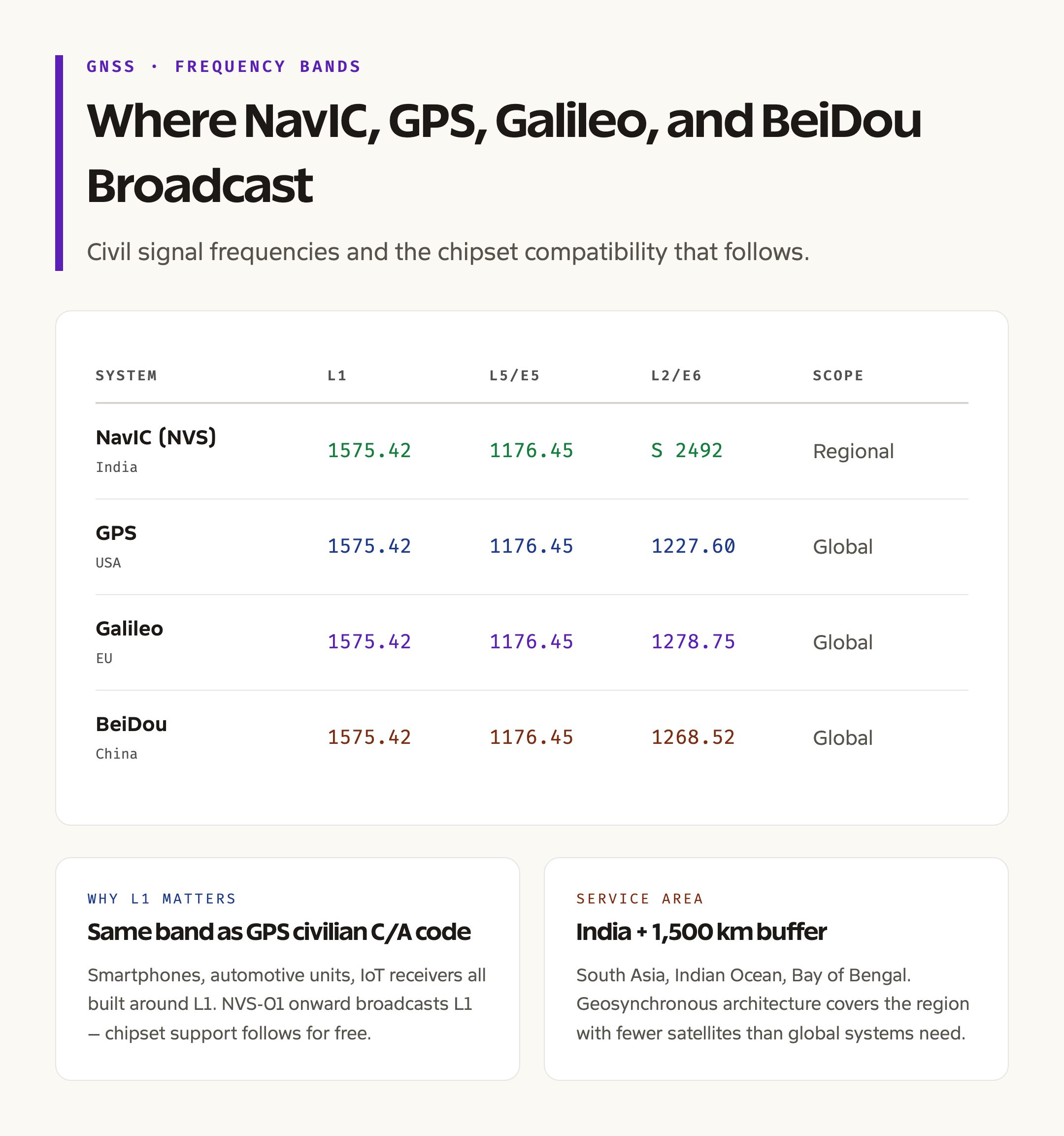
The second problem was signal coverage. The original constellation transmitted on L5 and S bands, neither of which is supported by mainstream consumer chipsets. Almost every smartphone, car navigation unit, and survey-grade receiver in the world is built around the L1 band that GPS uses. Without L1, NavIC could not be used by ordinary consumer devices unless chipset manufacturers added dedicated NavIC-only support, which most did not at scale.
The third problem was capacity. Civilian and strategic users needed more channels, more accurate timing for power-grid synchronisation, and search and rescue capability that the first generation did not include.
NVS-01 fixes all three. It carries an indigenous Rubidium Atomic Frequency Standard built by the Space Applications Centre at Ahmedabad, replacing the imported Swiss clocks of the IRNSS satellites. It adds the L1 band, making NavIC compatible with global consumer devices. It includes a ranging payload that supports the COSPAS-SARSAT international search and rescue programme, and it has more transponder channels with longer planned life.
Payload Architecture and Signal Capabilities
NVS-01 and NVS-02 carry two distinct payload sections. The navigation payload handles the core positioning and timing service. The ranging payload supports search and rescue beacons and additional services.
The navigation payload broadcasts on three frequency bands. L5 at around 1176 megahertz is used for high-precision dual-frequency civilian receivers and aviation safety services. S band at around 2492 megahertz is used by older NavIC-only receivers. L1 at around 1575 megahertz is the new addition. L1 is the same band that GPS uses for its civilian C/A code, which means smartphone chipsets, automotive units, and general consumer receivers can decode NavIC signals once firmware is updated to recognise the NavIC code structure. Qualcomm, MediaTek, and Broadcom chipsets in 2024 onward generations include NavIC L1 support.
The Rubidium Atomic Frequency Standard generates the master timing signal. ISRO’s Space Applications Centre developed the indigenous version after the IRNSS clock failures, and the in-orbit performance on NVS-01 has been within specification through 2024 and 2025. Each satellite carries multiple redundant clocks. Atomic clocks on navigation satellites must hold time to within nanoseconds over years, because every nanosecond of error translates to roughly 30 centimetres of positioning error on the ground.
The ranging payload supports the COSPAS-SARSAT distress alert system, allowing emergency beacons from ships, aircraft, and trekkers to be detected from the satellite and forwarded to ground rescue agencies. This is a strategic capability India did not have on the first-generation NavIC.
How NavIC Compares to GPS, Galileo, and BeiDou
NavIC is a regional system, not a global one. It is designed to provide positioning over India and a buffer zone of about 1,500 km beyond the borders, including parts of South Asia, the Indian Ocean, the Arabian Sea, and the Bay of Bengal. The satellites sit in geostationary and inclined geosynchronous orbits, all visible from the Indian region at all times, which gives strong geometric coverage with fewer satellites than a global system needs. We cover the head-to-head comparison in detail in our NavIC vs GPS vs Galileo vs BeiDou explainer.
GPS, the US system, runs 31 satellites in medium Earth orbit at around 20,200 km. Galileo, the European system, runs about 24 active satellites at similar altitude. BeiDou, the Chinese system, runs about 30 satellites in a mix of geostationary, inclined geosynchronous, and medium Earth orbits, and is the only system other than GPS with full global coverage. NavIC’s architecture is closer to BeiDou’s regional sub-system than to the GPS or Galileo style.
The accuracy specification for NavIC standard positioning service is better than 20 metres in the primary service area, comparable to the unaided civilian accuracy of GPS and Galileo. Restricted service, the encrypted military version, offers higher precision. Dual-frequency civilian users combining L1 and L5 can achieve accuracy of one to two metres after error correction.
Launch Vehicle and Operational Slot
Both NVS-01 and NVS-02 were launched on the GSLV Mark II. GSLV uses an indigenous cryogenic upper stage, the third stage that ignites in vacuum after the solid first stage and liquid second stage. The GSLV Mark II is rated for about 2,250 kilogrammes to geosynchronous transfer orbit, which suits the NVS satellite class. Heavier payloads use the GSLV Mark III, also called LVM3, which is the workhorse for the Gaganyaan mission and Chandrayaan-3.
After separation from the launch vehicle, the satellite is in a transfer orbit. Onboard liquid-apogee thrusters fire over a sequence of weeks to circularise the orbit at geosynchronous altitude of around 35,786 km. NVS-02 had an issue with one of these thrusters in February 2025, which was bypassed by ground teams using alternate manoeuvre planning. The operational orbit slot is allocated by the International Telecommunication Union and recorded with the United Nations Office for Outer Space Affairs.
Ground Segment and User Devices
The NavIC ground segment includes the Master Control Facility at Hassan and a backup facility at Bhopal, plus a network of Indian Range and Integrity Monitoring Stations distributed across the country and at a few overseas sites including Mauritius and Vietnam. The ground network monitors satellite positions, calculates orbit corrections, and uploads navigation messages to the satellites multiple times per day.
User devices fall into three categories. Standalone NavIC receivers used by surveyors, fishermen, and defence units. Multi-constellation chipsets in smartphones, vehicles, and IoT devices that combine NavIC with GPS, Galileo, and BeiDou for redundancy. Specialised receivers for power-grid timing, telecommunications, and stock-market timestamping that need only nanosecond-precision time, not position. The 2025 mandate for NavIC support in commercial smartphones sold in India accelerated chipset and firmware adoption.
Strategic Context: Why NavIC Matters
A regional satellite navigation system gives India three forms of strategic insurance. First, GPS could be denied or degraded over Indian territory in a contingency, as the US selectively did during the Kargil conflict in 1999. NavIC removes that vulnerability. Second, civilian L1 signals from foreign systems could be spoofed during a conflict, leading to false positions on Indian aircraft, ships, and ground vehicles. NavIC provides an independent crosscheck. Third, defence applications such as missile guidance, artillery fire control, and unmanned aerial vehicle navigation depend on continuous, reliable positioning that India can fully control.
There is also a civil dimension. Power-grid frequency synchronisation, mobile network timing, banking timestamps, agricultural mandi tracking, fisheries safety alerts, and disaster relief logistics all rely on positioning and timing. Routing all of this through a foreign system creates a strategic dependency that NavIC progressively reduces.
Constellation Status and Roadmap
NavIC reached operational status in 2018 with seven satellites. By 2023, four of the original IRNSS satellites had partial or total clock failures, reducing the constellation’s effective coverage and accuracy. NVS-01 in 2023 began the rebuild. NVS-02 followed in 2025. NVS-03, NVS-04, and NVS-05 are sanctioned and scheduled across 2025 to 2027. After all five are in orbit, NavIC will return to a healthy seven-satellite operational configuration with newer, more capable hardware.
Beyond the second generation, ISRO has flagged a possible expansion to a wider constellation that would extend coverage beyond the regional zone. The decision is partly geopolitical, since a globally available NavIC would compete more directly with GPS, Galileo, and BeiDou and would attract chipset adoption pressure of a different kind. As of 2026, no formal global NavIC programme has been announced.
Civilian and Commercial Applications
NavIC is now mandated for use in several Indian sectors. Commercial vehicle tracking under the AIS-140 specification is the largest. New trucks, buses, and taxis registered in many states are required to carry an AIS-140 telematics unit that transmits NavIC-determined position to a state control room. Fisheries departments distribute NavIC messaging devices to small fishing boats, allowing distress alerts and location updates from areas where mobile coverage is poor.
The Survey of India uses NavIC alongside GPS for cadastral and topographic surveys. The Indian Railways uses NavIC for track-side location services and signal timing. Agricultural drones for spraying and crop monitoring increasingly use multi-constellation receivers that include NavIC for redundancy.
The 2025 smartphone mandate is the largest reach. Most premium and mid-tier smartphones sold in India after 2024 include NavIC L1 support out of the box, which means hundreds of millions of consumer devices can fall back to NavIC if GPS is degraded.
What to Watch Going Forward
Three things will define the next phase of NavIC. The first is the completion of the second-generation rollout, which depends on NVS-03 through NVS-05 launching on schedule and reaching operational orbit. The second is firmware adoption across consumer chipsets, especially in budget smartphones below the 15,000-rupee price point where NavIC support has been less consistent. The third is the discussion around extending NavIC coverage internationally, which is more a strategic and diplomatic question than a technical one.
For UPSC GS-III, the policy story is the integration of NavIC into critical infrastructure, the strategic autonomy logic in defence, and the civilian dividend through mandatory adoption in transport and fisheries. The technological story is the indigenous atomic clock, the L1 signal addition, and the build-quality improvement on the second generation.
Frequently Asked Questions
What is the difference between NVS-01 and the older IRNSS satellites?
NVS-01 carries an indigenous Rubidium Atomic Frequency Standard, transmits on the L1 band in addition to L5 and S, and includes a ranging payload for search and rescue. The older IRNSS satellites used imported atomic clocks, did not transmit on L1, and lacked search and rescue capability. NVS-01 is heavier, more capable, and rated for longer operational life.
Why is the L1 band on NVS-01 important?
L1 is the band most consumer chipsets use for GPS reception. Without L1, NavIC required dedicated NavIC-only receiver hardware that few consumer devices included. With L1 on NVS-01 and onward, smartphones, automotive units, and IoT devices can receive NavIC signals using existing chipset architecture, which is why mainstream chipset vendors began adding NavIC support from 2024.
What is the COSPAS-SARSAT payload on NVS-01 and NVS-02?
COSPAS-SARSAT is an international satellite-based search and rescue system. The ranging payload on NVS satellites detects emergency distress beacons from ships, aircraft, and trekkers in the Indian region and forwards the alert to ground rescue agencies. This was not a feature on the first-generation IRNSS satellites.
How does NavIC compare to GPS in coverage?
NavIC is a regional system covering India and a buffer of about 1,500 km beyond the borders. GPS is a global system. Inside the NavIC service area, the two systems offer comparable accuracy for civilian users, and dual-system receivers combining both achieve better reliability than either alone.
Who builds and operates NVS-01 and NVS-02?
Both satellites are designed and built by ISRO, primarily at the U.R. Rao Satellite Centre in Bengaluru and the Space Applications Centre in Ahmedabad. They are launched from the Satish Dhawan Space Centre at Sriharikota and operated from the Master Control Facility at Hassan, Karnataka, with a backup facility at Bhopal.
Tell Google you want more of this.
Add Anantam IAS as a preferred sourceOne tap, and this site shows up more often in your own Top Stories, AI Overviews and AI Mode. Remove it any time.