Disclosure: this guide contains Amazon affiliate links. As an Amazon Associate, Anantam IAS earns from qualifying purchases — at no extra cost to you.
Trace a single drop of water from a cave of blue ice in the high Himalaya, and within two and a half thousand kilometres it will have passed under the prayers of pilgrims at Haridwar, carried grain barges past Varanasi, watered the wheat fields that feed a third of the country, and finally fanned out into the largest delta on Earth before reaching the sea. No other river touches so many Indian lives. The Ganga drains India’s largest river basin and supports close to half the national population, which is why it sits at the centre of so much — geography, agriculture, faith, and a clean-up effort that has now run for four decades.
For an aspirant, that breadth is the point. The Ganga is a GS Paper 1 topic when you map its source, course and tributaries, and a GS Paper 3 topic the moment you ask why it’s so polluted and what Namami Gange has actually achieved. So this is a river you can be questioned on from two very different directions in the same exam, and the smart move is to learn it as one connected system rather than two disconnected lists.
Source and Course of the Ganga
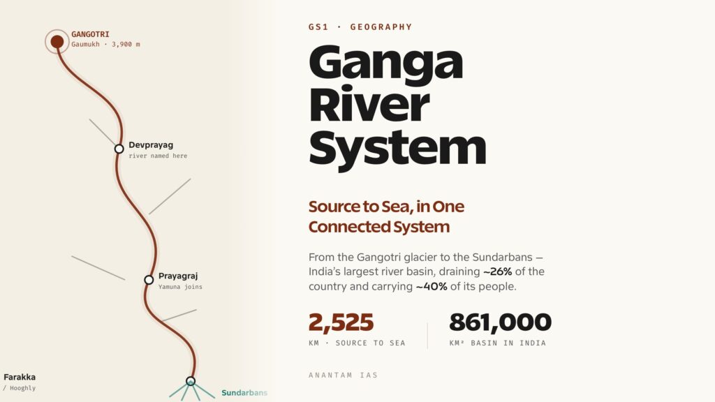
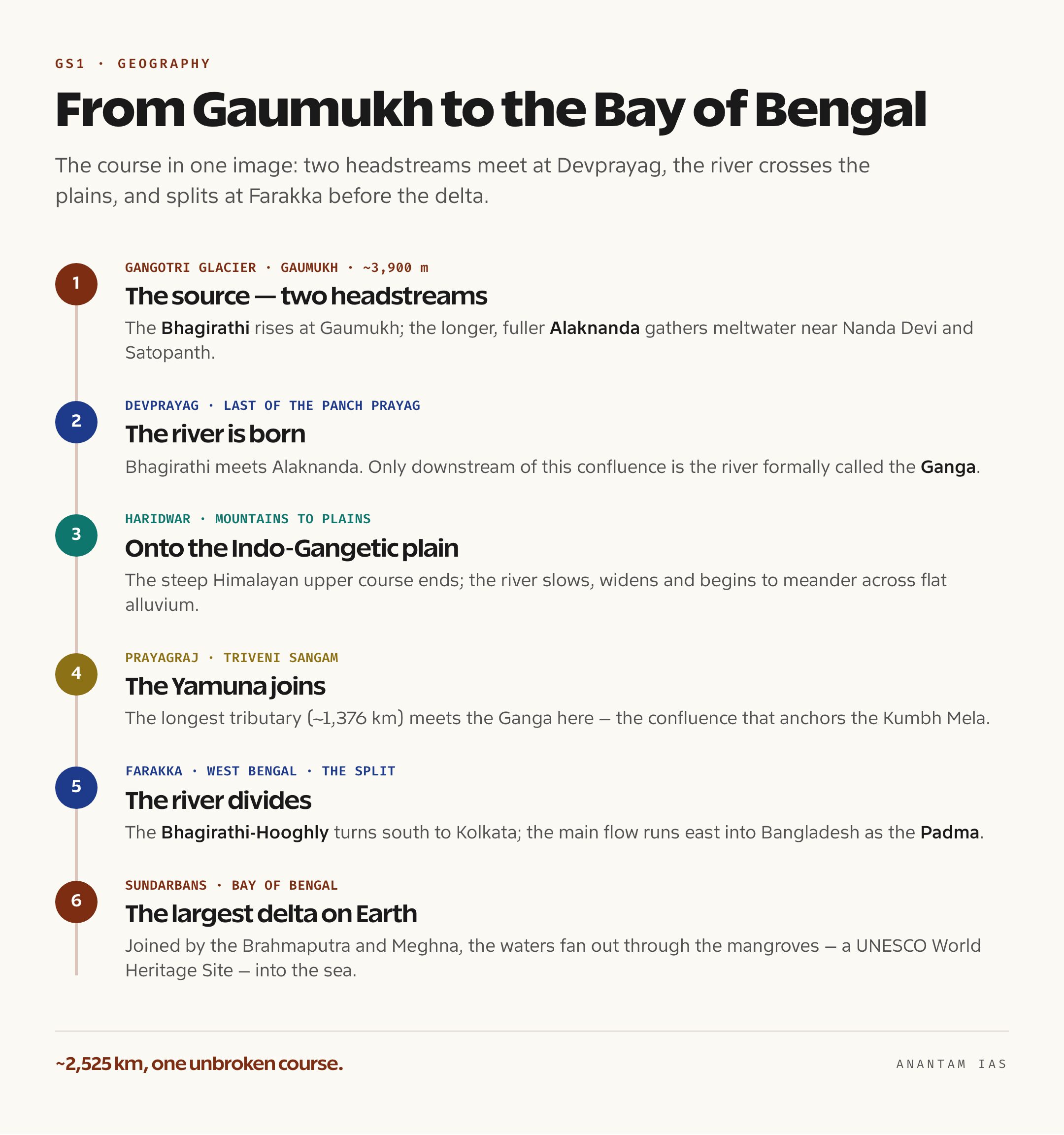
The Ganga doesn’t start as the Ganga. It begins as two Himalayan headstreams that only earn the name once they meet. The senior of the two by tradition is the Bhagirathi, which emerges from the snout of the Gangotri glacier at Gaumukh — literally “cow’s mouth” — at roughly 3,900 metres in Uttarkashi district, Uttarakhand. The longer and more voluminous of the two is the Alaknanda, which gathers meltwater from the slopes around Nanda Devi and Satopanth. The two rivers join at Devprayag, and only from that confluence downstream is the river formally called the Ganga.

Oxford Student Atlas for India — 7th Edition
- 160 pages, Oxford University Press, the current edition
- India-focused thematic maps: physical, political, rivers, climate, soils, vegetation, plus world maps
- Made for UPSC and state PSC map work; slim enough to stay open beside the textbook
The Alaknanda’s descent is itself a chain of confluences that pilgrims know as the Panch Prayag, the five sacred meeting points. In order from the upper mountains down to Devprayag they are Vishnuprayag (Alaknanda meets the Dhauliganga), Nandaprayag (the Nandakini), Karnaprayag (the Pindar), Rudraprayag (the Mandakini), and finally Devprayag, where the Bhagirathi joins and the Ganga is born. Knowing the order, not just the names, is what separates a confident Prelims answer from a guess.
From Devprayag the river runs down to Haridwar, where it leaves the mountains and spills onto the plains. Geographers usually split the journey into three stretches: the upper course from Gangotri to Haridwar, a steep Himalayan descent through gorges; the middle course from Haridwar to Prayagraj, where the river slows, widens and starts to meander across flat alluvium; and the lower course from Prayagraj to the sea, where it becomes a sluggish, sediment-heavy giant. Along the way it sweeps in a vast arc across the Indo-Gangetic plain — through Kanpur, Prayagraj, Varanasi and Patna — picking up tributary after tributary on both banks. The total length is about 2,525 kilometres, of which the longest single stretch runs through Uttar Pradesh.
Near Farakka in West Bengal the river splits. One arm, the Bhagirathi-Hooghly, turns south through Kolkata, and the Farakka Barrage was built precisely to divert flow down this channel to flush silt out of Kolkata port. The main flow continues east into Bangladesh as the Padma, where it meets the Brahmaputra (called the Jamuna in Bangladesh) and then the Meghna. The combined waters empty into the Bay of Bengal through the Sundarbans, the world’s largest delta and a UNESCO World Heritage Site shared by India and Bangladesh — a maze of tidal creeks and mangrove that is also the last stronghold of the Royal Bengal tiger.
The Tributaries and the Basin
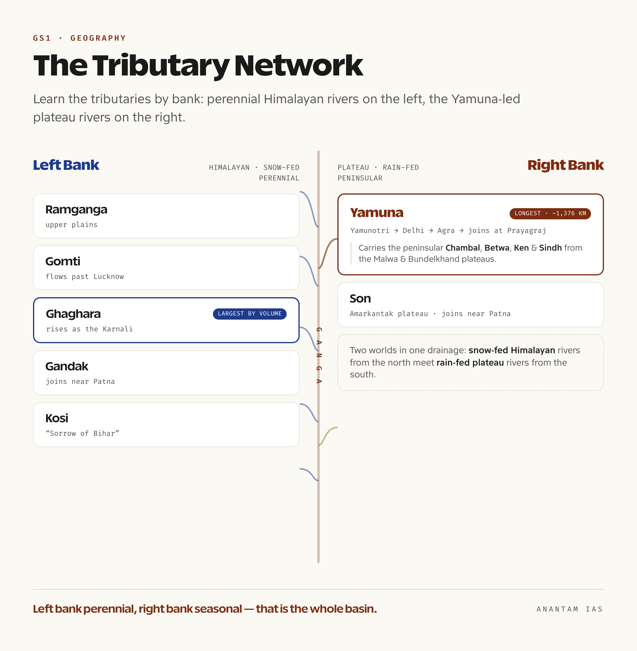
The Ganga’s power comes from its tributaries, and the cleanest way to hold them in your head is by bank. The left-bank tributaries are the great Himalayan rivers, perennial because they are fed by snowmelt as well as monsoon rain. Running roughly upstream to downstream, they are the Ramganga, the Gomti (which flows past Lucknow), the Ghaghara — the single largest tributary by water volume, rising in the Tibetan Himalaya as the Karnali — the Gandak, which joins near Patna, and the Kosi, long nicknamed the “Sorrow of Bihar” for the catastrophic floods it causes when it shifts its channel across the plain.
The right-bank tributaries are led, by a wide margin, by the Yamuna, the Ganga’s longest tributary at about 1,376 kilometres. The Yamuna rises at the Yamunotri glacier, flows past Delhi and Agra, and joins the Ganga at Prayagraj’s Triveni Sangam — the confluence that anchors the Kumbh Mela. The Yamuna is itself a system: it carries the peninsular waters of the Chambal, Betwa, Ken and Sindh down from the Malwa and Bundelkhand plateaus, so the Chambal effectively reaches the Ganga through the Yamuna. The other major right-bank tributary is the Son, which rises on the Amarkantak plateau and joins near Patna. So the basin blends two very different worlds — snow-fed Himalayan rivers from the north and rain-fed plateau rivers from the south — in one drainage.
That blend explains the scale of the basin. The Ganga basin is India’s largest, draining about 861,000 square kilometres within India alone — roughly 26 percent of the country’s geographical area — and spreading across Uttarakhand, Uttar Pradesh, Madhya Pradesh, Rajasthan, Haryana, Himachal Pradesh, Chhattisgarh, Jharkhand, Bihar, West Bengal and Delhi. The wider transboundary basin extends into Nepal, China (Tibet) and Bangladesh. Its soils are deep, young alluvium — among the most fertile anywhere on Earth — and its monsoon-fed climate makes it the demographic heartland of India, home to roughly 40 percent of the national population.
Why the Ganga System Matters
The first reason is food. The Indo-Gangetic plain that the Ganga and its tributaries built is the agricultural engine of India — the belt where the Green Revolution took deepest root, and where rice, wheat, sugarcane and pulses are grown on a scale that underwrites national food security. Canal systems such as the Upper Ganga Canal and the Sharda Canal spread that water across the fields, and the river’s groundwater recharge feeds millions of tube wells. When people say the Ganga basin feeds India, it isn’t a figure of speech.
The second reason is movement and energy. The Ganga carries National Waterway-1 (NW-1), the 1,620-kilometre stretch from Haldia to Prayagraj that is India’s longest national waterway, now being deepened and equipped with terminals under the World-Bank-backed Jal Marg Vikas Project. The payoff is visible in the cargo numbers: traffic on NW-1 rose from about 5 million tonnes in 2014-15 to roughly 16 million tonnes in 2024-25. The basin also carries major water infrastructure, from the Tehri Dam on the Bhagirathi to the Farakka Barrage that manages flow between the Hooghly and the Padma.
The third reason is harder to put on a map. The Ganga is sacred to Hindus along its whole length, and its banks hold the great pilgrimage cities of Haridwar, Prayagraj, Varanasi and Patna. The Maha Kumbh at Prayagraj in 2025 drew an estimated 660 million visits over six weeks, making it the largest human gathering ever recorded — a reminder that for hundreds of millions the river is not a resource but a deity. That faith is a double-edged force: it generates an unmatched constituency for the river’s protection, but it also concentrates enormous human and ritual pressure on a few stretches of bank at once.
The basin is also a biodiversity refuge. It shelters the gharial, smooth-coated otters, freshwater turtles, the prized hilsa fish, and the Ganga river dolphin, India’s National Aquatic Animal since 2009. The dolphin matters far beyond symbolism: it is nearly blind and navigates by echolocation, so it can only survive in deep, clean, free-flowing stretches — which makes its presence the single best indicator that a reach of the river is genuinely healthy. Where the dolphin disappears, the river has usually already died in all but name.
Pollution and Threats
For all that significance, the Ganga is one of the most stressed rivers in the world, and the largest single cause is mundane: sewage. The bulk of the pollution load is untreated domestic sewage from the hundreds of towns along the banks, not industry — though tanneries at Kanpur, along with sugar, paper and chemical units, add a concentrated toxic burden. The honest picture surfaced at the 2025 Maha Kumbh itself, when monitoring found faecal coliform counts at the Sangam spiking far above the safe-bathing limit on some days even as official summaries reported the water broadly fit for bathing. Both readings can be partly true — the river’s quality swings sharply by location and by day — but the spikes show how fragile the gains are when tens of millions gather on the banks.
The threats stack on top of each other. Climate change is thinning the river’s source: the Gangotri glacier has been retreating at an average of roughly 15 to 20 metres a year, which threatens the lean-season flow that keeps the river diluting its own pollution. Over-abstraction for irrigation and cities cuts the environmental flow — the minimum current the river needs to stay alive — so that in places the Ganga runs low and sluggish, unable to flush itself. Sand mining, floodplain encroachment, and the recurring floods of the Kosi and Ghaghara belt round out the pressure. And the dolphin is the barometer for all of it: the first comprehensive count under Project Dolphin, the Population Status of River Dolphin in India 2024 report released in March 2025, put the Ganga river dolphin population at 6,324 across the Ganga and Brahmaputra basins, with about 5,689 in the Ganga system. That figure is both reassuring and a warning — the species survives, but it survives because the river still has enough deep, clean water in stretches, and those stretches are shrinking.
Conservation and the Way Forward
India’s response has run through three generations of programmes. The Ganga Action Plan of 1985 was the first organised clean-up, and it largely failed because it focused on building sewage plants without securing the flow or the maintenance to run them. The Ganga was declared a National River in 2008, which led to the National Ganga River Basin Authority and a shift toward treating the whole basin as one unit. Then came the umbrella programme that matters most today: the Namami Gange mission, launched in 2014 and run by the National Mission for Clean Ganga (NMCG), with an initial outlay of 20,000 crore rupees later expanded to 22,500 crore.
The progress is real but unfinished, and the data shows both. By 2025, NMCG reported that of the 492 projects sanctioned under Namami Gange, more than 300 were completed and operational, with installed sewage treatment capacity reaching close to 3,977 million litres a day across some 138 treatment plants — and the mission is targeting roughly 7,000 MLD of treatment capacity. New plants commissioned in 2025 at Farrukhabad, Ayodhya and elsewhere added hundreds of MLD in a single year. The model has shifted too: from one-off projects to a hybrid-annuity approach that pays private operators to actually run the plants for years, fixing the maintenance failure that doomed the earlier action plans.
So where does the way forward point? The answer is to treat the river as a system, not a series of construction contracts. That means closing the gap between sewage generated and sewage treated, since capacity on paper means nothing if the effluent never reaches the plant. It means guaranteeing environmental flow so the river retains the current it needs to dilute and self-clean, especially in the lean season. It means cleaning the tributaries — a polluted Yamuna or Ramganga simply re-pollutes the Ganga downstream. And it means making conservation a public habit rather than a government programme, because a river worshipped by half a country can only stay clean if the people who revere it stop treating it as a drain. The dolphin, the delta and the wheat fields all depend on the same thing: enough clean water, flowing.
For Your Mains Answer
The Ganga river system is a dual-purpose topic. For GS Paper 1 it sits squarely in physical and economic geography — drainage systems, Himalayan versus peninsular rivers, the Indo-Gangetic plain as India’s heartland. For GS Paper 3 it becomes an environment-and-conservation question about river pollution, the Namami Gange programme, inland waterways, and the impact of climate change on glacier-fed rivers. The candidates who score treat these as one connected argument: the geography explains why the river matters, and the geography also explains why it’s so hard to clean.
How to Build the Answer
Open with the system, not a definition. Establish the source and the headstreams (Bhagirathi and Alaknanda meeting at Devprayag), then move to the tributary network by bank, then to the basin’s scale and significance — food, transport, faith, biodiversity. Only after you’ve shown why the river matters do you turn to the threats and the policy response. That arc — source, network, significance, threat, response — answers almost any Ganga question, whether the prompt is about geography or about the effectiveness of Namami Gange.
Common Mistakes to Avoid
Don’t confuse the headstreams: the Bhagirathi comes from Gangotri/Gaumukh, the Alaknanda is the longer stream, and the Ganga is named only below Devprayag. Don’t mix up the banks — the Yamuna and Son are right-bank, the Ghaghara, Gandak and Kosi are left-bank. Don’t call industry the main polluter; untreated domestic sewage carries the bulk of the load. And don’t present Namami Gange as either a triumph or a failure — cite the completed-versus-sanctioned project numbers and the treated-versus-generated sewage gap to show balance.
A Compact Answer Spine
Two headstreams (Bhagirathi from Gangotri, Alaknanda via the Panch Prayag) meet at Devprayag → ~2,525 km course across the Indo-Gangetic plain to the Sundarbans delta → left-bank Himalayan tributaries (Ramganga, Gomti, Ghaghara, Gandak, Kosi) and right-bank rivers led by the Yamuna → India’s largest basin (~26% of the country, ~40% of its people) → significance in food, NW-1 transport, faith and the dolphin → threats (sewage, glacier retreat, low environmental flow) → response (GAP 1985, National River 2008, Namami Gange/NMCG 2014) → way forward (close the treatment gap, secure e-flow, clean tributaries).
Diagram or Flowchart Idea
Draw a single longitudinal profile of the river: Gaumukh at the top-left, Devprayag where the two headstreams merge, then nodes for Haridwar, Prayagraj (label the Yamuna joining here), Patna, Farakka (label the Padma/Hooghly split), and the Sundarbans at the bottom-right. Mark left-bank tributaries above the line and right-bank below it. A clean source-to-sea profile like this proves you understand the system and is quick to reproduce under time pressure.
A Balanced-Conclusion Line
End on the system, not a slogan: the Ganga will not be saved by building more treatment plants alone, but by guaranteeing the river the clean flow it needs to heal itself — which makes the Ganga’s revival a test of whether India can manage a whole basin, not just a riverbank.
How to Use Data Without Cramming
Pick a handful of anchors and stop: ~2,525 km long; basin ~26% of India’s area carrying ~40% of its people; Namami Gange launched 2014 with over 300 of 492 projects complete and ~3,977 MLD of treatment capacity; the river dolphin count of 6,324 in the 2024 survey. Four precise figures, each tied to a point, beat a paragraph of half-remembered statistics.
FAQ
Where does the Ganga originate, and where does it get its name? The Ganga begins as two Himalayan headstreams: the Bhagirathi, which rises from the Gangotri glacier at Gaumukh in Uttarakhand, and the longer Alaknanda. They meet at Devprayag, and only downstream of that confluence is the river formally called the Ganga. It runs about 2,525 kilometres to the Bay of Bengal.
What are the main tributaries of the Ganga? On the left bank, the perennial Himalayan tributaries are the Ramganga, Gomti, Ghaghara (the largest by volume), Gandak and Kosi. On the right bank, the Yamuna is the longest tributary — itself carrying the Chambal, Betwa, Ken and Sindh — followed by the Son. The mix of snow-fed and rain-fed rivers gives the basin its scale.
Why is the Ganga so polluted, and what is being done about it? The largest cause is untreated domestic sewage from riverside towns, with industrial effluent adding a concentrated toxic load. The clean-up runs through the Namami Gange mission, launched in 2014 under the National Mission for Clean Ganga, which by 2025 had completed over 300 of 492 projects and built close to 3,977 MLD of sewage treatment capacity, using a hybrid-annuity model to keep plants running.
What is the Ganga river dolphin, and why does it matter? The Ganga river dolphin is India’s National Aquatic Animal, declared in 2009, and a key indicator of the river’s health because it needs deep, clean water. The first comprehensive count, the Population Status of River Dolphin in India 2024 report released in 2025, estimated 6,324 dolphins across the Ganga and Brahmaputra basins, with most living in the Ganga system.
Practice Questions
Prelims MCQs
- With reference to the origin of the Ganga, consider the following:
1. The Bhagirathi rises from the Gangotri glacier at Gaumukh.
2. The Bhagirathi and the Alaknanda meet at Devprayag.
3. The river is called the Ganga from Gaumukh onwards.
Which of the statements are correct?
(a) 1 and 2 only
(b) 2 and 3 only
(c) 1 and 3 only
(d) 1, 2 and 3
Answer: (a) The Bhagirathi rises at Gaumukh from the Gangotri glacier and meets the Alaknanda at Devprayag; the river is named “Ganga” only below that confluence, not from Gaumukh. - Which one of the following is the correct upstream-to-downstream order of the Panch Prayag along the Alaknanda?
(a) Devprayag, Rudraprayag, Karnaprayag, Nandaprayag, Vishnuprayag
(b) Vishnuprayag, Nandaprayag, Karnaprayag, Rudraprayag, Devprayag
(c) Vishnuprayag, Karnaprayag, Nandaprayag, Devprayag, Rudraprayag
(d) Nandaprayag, Vishnuprayag, Rudraprayag, Karnaprayag, Devprayag
Answer: (b) From the high mountains down to where the Ganga is born, the order is Vishnuprayag, Nandaprayag, Karnaprayag, Rudraprayag and Devprayag. - Which of the following are left-bank tributaries of the Ganga? 1. Ghaghara 2. Gandak 3. Son 4. Kosi
(a) 1, 2 and 4 only
(b) 1, 3 and 4 only
(c) 2 and 3 only
(d) 1, 2, 3 and 4
Answer: (a) The Ghaghara, Gandak and Kosi are left-bank Himalayan tributaries; the Son is a right-bank tributary rising on the Amarkantak plateau. - Consider the following about the Ganga basin:
1. It is the largest river basin in India.
2. It covers roughly one-fourth of India’s geographical area.
3. The Yamuna is the longest tributary of the Ganga.
Which of the statements are correct?
(a) 1 and 2 only
(b) 2 and 3 only
(c) 1 and 3 only
(d) 1, 2 and 3
Answer: (d) The Ganga basin is India’s largest, draining about 861,000 sq km or roughly 26% of the country, and the Yamuna (~1,376 km) is its longest tributary. - The Ganga river dolphin, in the news in recent years, is best described as:
(a) the National Aquatic Animal of India, declared in 2009
(b) a marine species found only in the Gulf of Mannar
(c) an invasive species threatening native fish
(d) the state animal of West Bengal
Answer: (a) The Ganga river dolphin was declared India’s National Aquatic Animal in 2009 and serves as an indicator of the river’s ecological health; the 2024 survey estimated 6,324 across the Ganga-Brahmaputra basins.
Mains Practice Questions
- “The Ganga basin is both the agricultural heartland and the ecological frontline of India.” Examine the geographical reasons for its significance and the pressures that threaten it. (15 marks, 250 words)
- Critically evaluate the effectiveness of the Namami Gange programme in cleaning the Ganga, distinguishing it from the earlier Ganga Action Plan. (15 marks, 250 words)
- Distinguish between the left-bank and right-bank tributaries of the Ganga and explain how their differing regimes shape the river’s flow through the year. (10 marks, 150 words)
- “Building sewage treatment capacity alone cannot revive a river.” Discuss with reference to environmental flow, tributary pollution and public participation in the Ganga’s rejuvenation. (15 marks, 250 words)
- Examine the impact of climate change on Himalayan glacier-fed rivers, using the Gangotri glacier and the Ganga’s lean-season flow as a case study. (10 marks, 150 words)
Tell Google you want more of this.
Add Anantam IAS as a preferred sourceOne tap, and this site shows up more often in your own Top Stories, AI Overviews and AI Mode. Remove it any time.