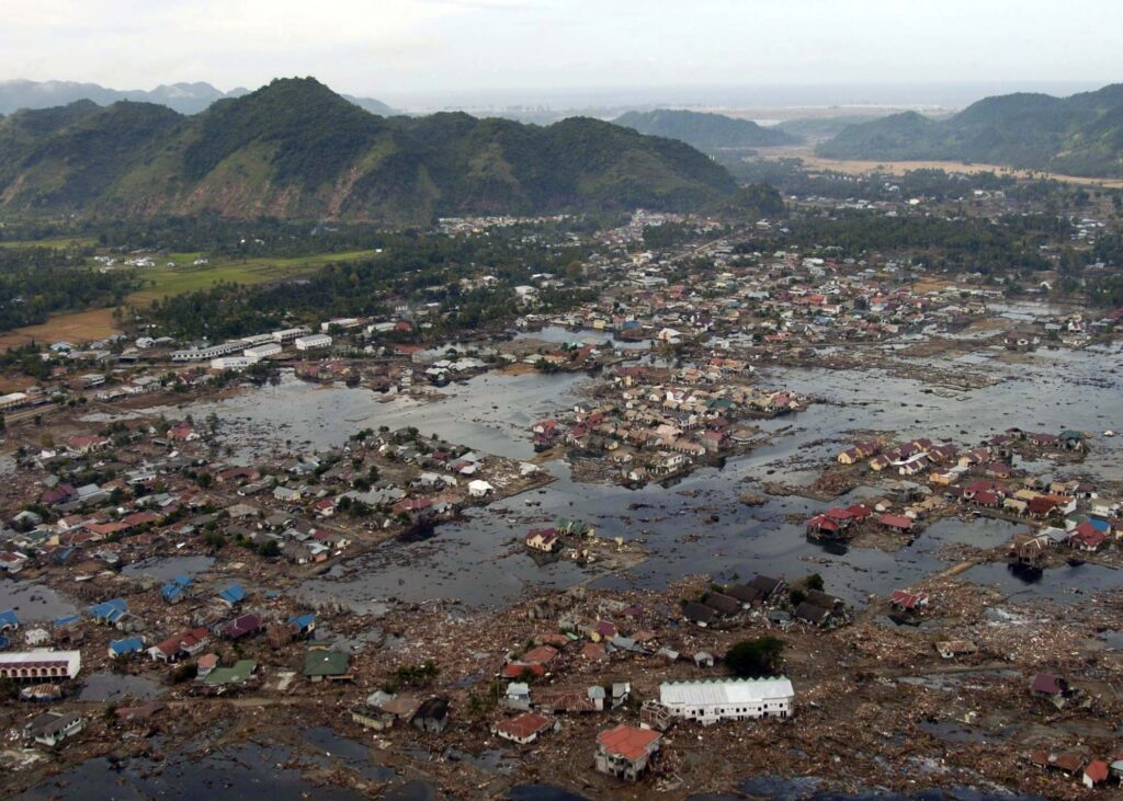
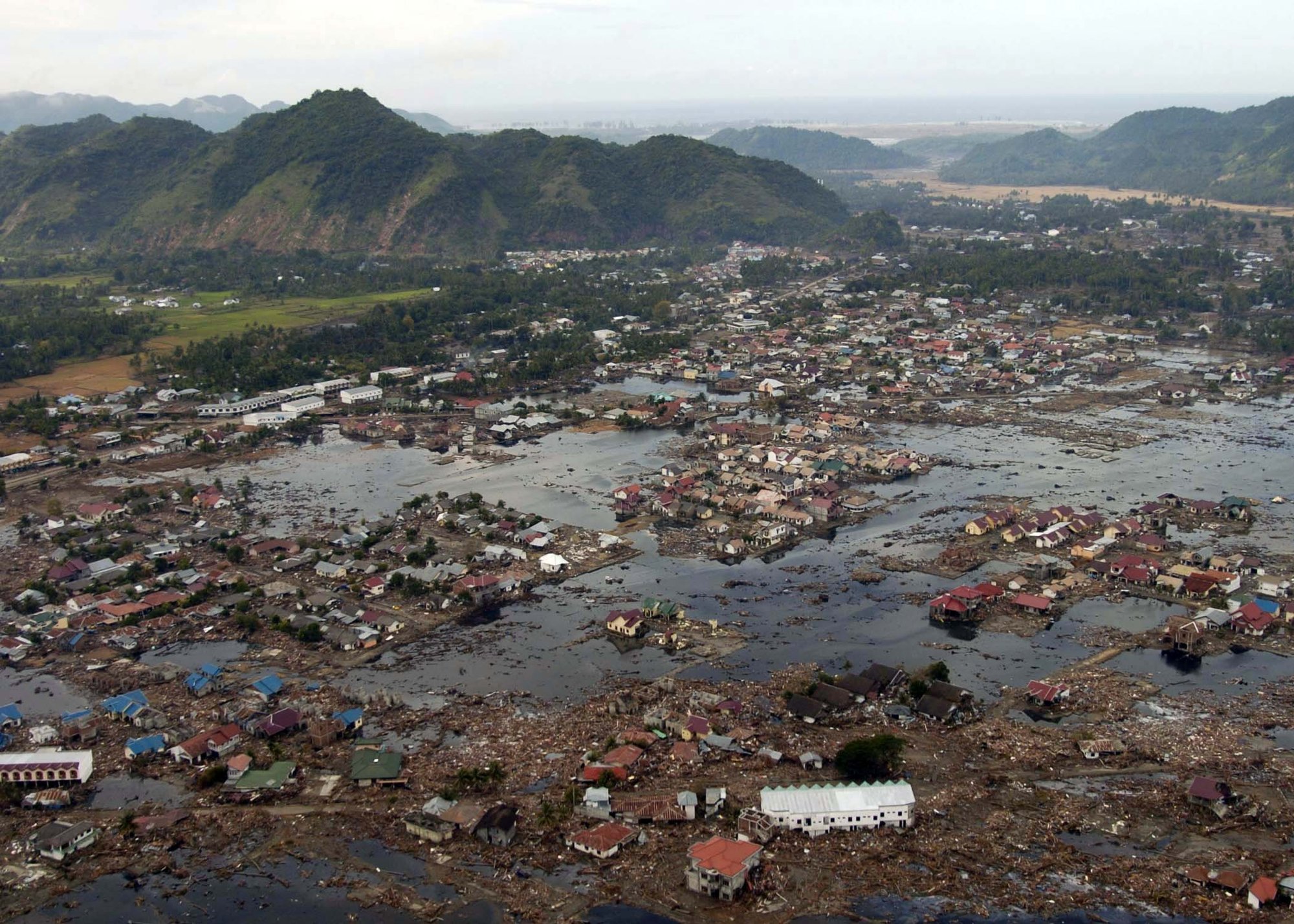
The Indian Ocean Tsunami 2004 is the single worst natural disaster of the 21st century by death toll. A magnitude 9.1 to 9.3 megathrust earthquake off the western coast of northern Sumatra on the morning of 26 December 2004 displaced enormous volumes of seawater along a 1,300 km rupture zone. The waves that followed crossed the Indian Ocean at jetliner speed and broke on shores from Indonesia to the east coast of Africa within hours. The combined toll across fourteen countries was over 230,000 dead and missing. India alone lost roughly 12,000 lives, with a further 5,000 missing whose bodies were never recovered.
India was the third-worst-hit country after Indonesia and Sri Lanka. Tamil Nadu’s coast, Andhra Pradesh, Kerala, Puducherry’s Karaikal enclave, and the Andaman and Nicobar Islands absorbed the impact. The Andaman and Nicobar group sat closest to the rupture and suffered both the earthquake’s shaking and the wave’s run-up. Indira Point, the southernmost tip of India, subsided by several metres. Tribal communities on the Nicobar Islands lost villages overnight.
The disaster reshaped Indian disaster management policy. The Disaster Management Act, 2005 was rushed through Parliament with cross-party consensus. The National Disaster Management Authority was constituted. The Indian National Centre for Ocean Information Services in Hyderabad was given the mandate to build a tsunami early warning system that became operational in 2007. This explainer walks through the science, the human toll, the institutional response, and the lessons UPSC General Studies Paper 1 and Paper 3 candidates need to carry into the exam hall.
Quick Facts at a Glance
- Date and time: 26 December 2004, 00:58 UTC (06:28 IST)
- Earthquake magnitude: Mw 9.1 to 9.3 (the third strongest earthquake recorded since seismographs began)
- Epicentre: Off the west coast of northern Sumatra, Indonesia, at a depth of about 30 km
- Rupture length: Approximately 1,300 km along the Sunda megathrust
- Total global death toll: Around 230,000 to 280,000 across fourteen countries
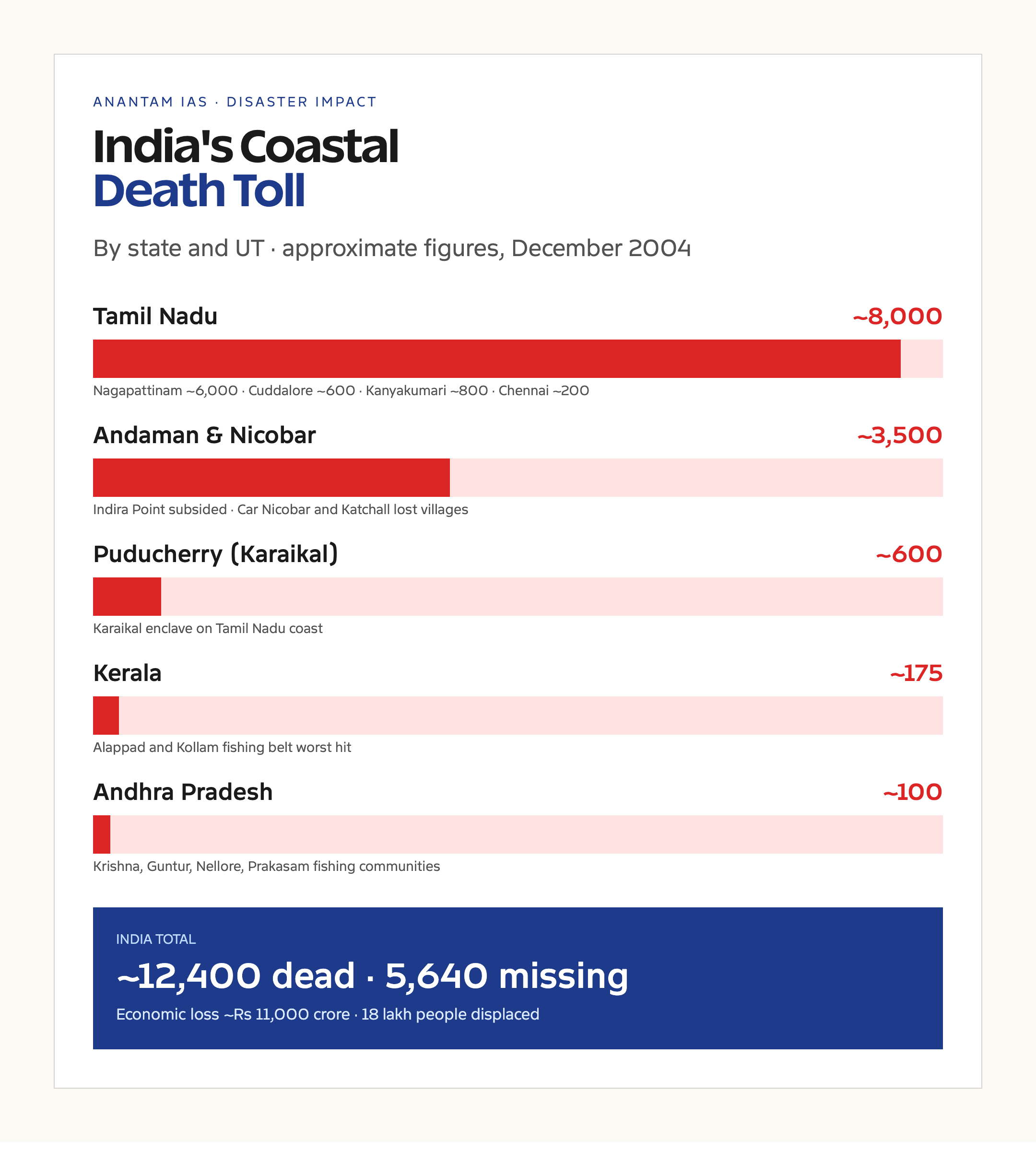
- Indian death toll: Approximately 12,400 confirmed dead, 5,640 missing (Tamil Nadu, Andhra Pradesh, Kerala, Puducherry, Andaman & Nicobar)
- Worst-hit Indian state: Tamil Nadu, with around 8,000 dead, especially in Nagapattinam district
- Andaman & Nicobar: Approximately 3,500 dead and missing; Indira Point subsided several metres
- Wave heights at Indian coast: 2 to 5 metres on the mainland, up to 15 metres at Nicobar
- Time from earthquake to Indian east coast: About 2 hours
- Institutional response: Disaster Management Act 2005, NDMA constituted, Indian Tsunami Early Warning Centre operational 2007 at INCOIS, Hyderabad
What the Indian Ocean Tsunami of 2004 Was
A tsunami is a series of ocean waves caused by the sudden vertical displacement of a large volume of water. The trigger is usually a submarine earthquake on a thrust fault, but submarine landslides and volcanic eruptions can also generate tsunamis. The 2004 event was a textbook megathrust earthquake on the Sunda subduction zone, where the Indian Plate is pushed under the Burma Plate at roughly 50 mm per year.
The rupture started near Simeulue Island off Sumatra and propagated north-northwest for about 1,300 km in around 8 minutes. The seafloor along the rupture rose by several metres. The displaced water column became a wave that, in the deep ocean, travelled at over 700 km per hour with a wave height of less than a metre. The wave is barely noticeable in the open sea but compresses as it enters shallow water near coasts, slowing to about 30 to 50 km per hour and rising sharply.
India had no tsunami warning system in 2004. The Pacific Tsunami Warning Center in Hawaii had detected the earthquake within minutes but lacked an Indian Ocean alerting network. Calls to Indian Ocean countries went unanswered or reached organisations without authority to evacuate coasts. The result was that the first wave reached Andaman and Nicobar within 15 to 20 minutes, Sri Lanka in about 90 minutes, and the Tamil Nadu coast in about 2 hours, with virtually no public warning.
Background and Historical Context
Tsunamis are not unknown to the Indian Ocean. The 1881 Car Nicobar earthquake produced a regional tsunami. The 1883 Krakatoa eruption sent waves that reached India. The 1941 Andaman Sea earthquake also caused localised inundation. None of these had been studied in any depth and none had entered school textbooks. The Indian Ocean coastal community lacked the cultural memory that Japanese or Chilean communities have, where tsunami evacuation drills are routine.
The Sunda megathrust itself had been known to seismologists as a major fault, but the 2004 rupture was larger than most models had predicted. The fault had last released a major event in 1797 and 1833. Strain accumulation over two centuries broke loose in the December 2004 event and a major aftershock, the magnitude 8.6 Nias earthquake, on 28 March 2005.
The 2004 disaster sat in a particular Indian policy context. Disaster management was a state subject under the Constitution, with no statutory central authority. The Department of Agriculture handled relief, the Indian Meteorological Department had a limited cyclone warning role, and there was no integrated framework. The Yashpal Committee on Disaster Management (1999) had recommended a comprehensive law, but no draft had moved. The Indian Ocean Tsunami forced the hand of the Manmohan Singh government, which introduced the Disaster Management Bill 2005 within months.
India’s Coastal Impact in Detail
Tamil Nadu lost approximately 8,000 lives. Nagapattinam district was the worst hit, with around 6,000 deaths, followed by Cuddalore (around 600), Kanyakumari (around 800), and Chennai (around 200). The Marina Beach in Chennai, normally crowded on a Sunday morning, was struck by a 5-metre wave at around 9 a.m. local time. The Velankanni shrine in Nagapattinam, packed with pilgrims, lost hundreds of devotees. Fishing villages along the entire coast were destroyed.
Andhra Pradesh lost around 100 lives, mostly fishermen and shoreline residents in Krishna, Guntur, Nellore, and Prakasam districts. The lower wave amplitude at the Andhra coast (around 2 to 3 metres) kept the toll moderate.
Kerala registered around 175 deaths, primarily in Kollam district at Alappad and the surrounding fishing belt. The southwest-facing coast was partly sheltered, which limited the damage.
Puducherry’s Karaikal enclave (situated in Tamil Nadu) lost around 600 lives. The main Puducherry beach had a 2-3 metre wave that pushed water into the central streets.
Andaman & Nicobar Islands sat closest to the epicentre and felt both the earthquake and the tsunami. The earthquake itself was magnitude 8 or higher as locally experienced. The southernmost Nicobar Islands subsided several metres, with Indira Point’s lighthouse partially submerged. Car Nicobar, Katchall, Nancowry, and Trinkat lost villages. Around 3,500 dead and missing were recorded across the islands, including tribal communities such as the Onge and the Nicobarese. The Sentinelese on North Sentinel Island appear to have survived, possibly because their inland location and traditional knowledge moved them to higher ground.
The economic loss to India was estimated at around Rs 11,000 crore in 2004 prices, covering housing, fishing infrastructure, ports, agricultural land salinised by seawater, and the cost of rehabilitation.
Why the Tsunami Matters for Indian Policy
The 2004 tsunami sits as a foundational event for Indian disaster governance the same way the Bhopal disaster of 1984 sits for industrial safety. Three institutional shifts followed.
First, the Disaster Management Act 2005 was enacted in December 2005. It created the National Disaster Management Authority at the central level, State Disaster Management Authorities at the state level, and District Disaster Management Authorities at the district level. Section 6 gave NDMA the power to lay down policies and guidelines for disaster management. The Act made disaster management a concurrent statutory subject, even though it remains constitutionally a state subject.
Second, NDMA, SDMA, and DDMA were progressively constituted from 2005 onwards under the Act. The NDMA, chaired by the Prime Minister, was given powers to approve the National Plan and to direct ministries on disaster response. The first National Policy on Disaster Management was notified in 2009.
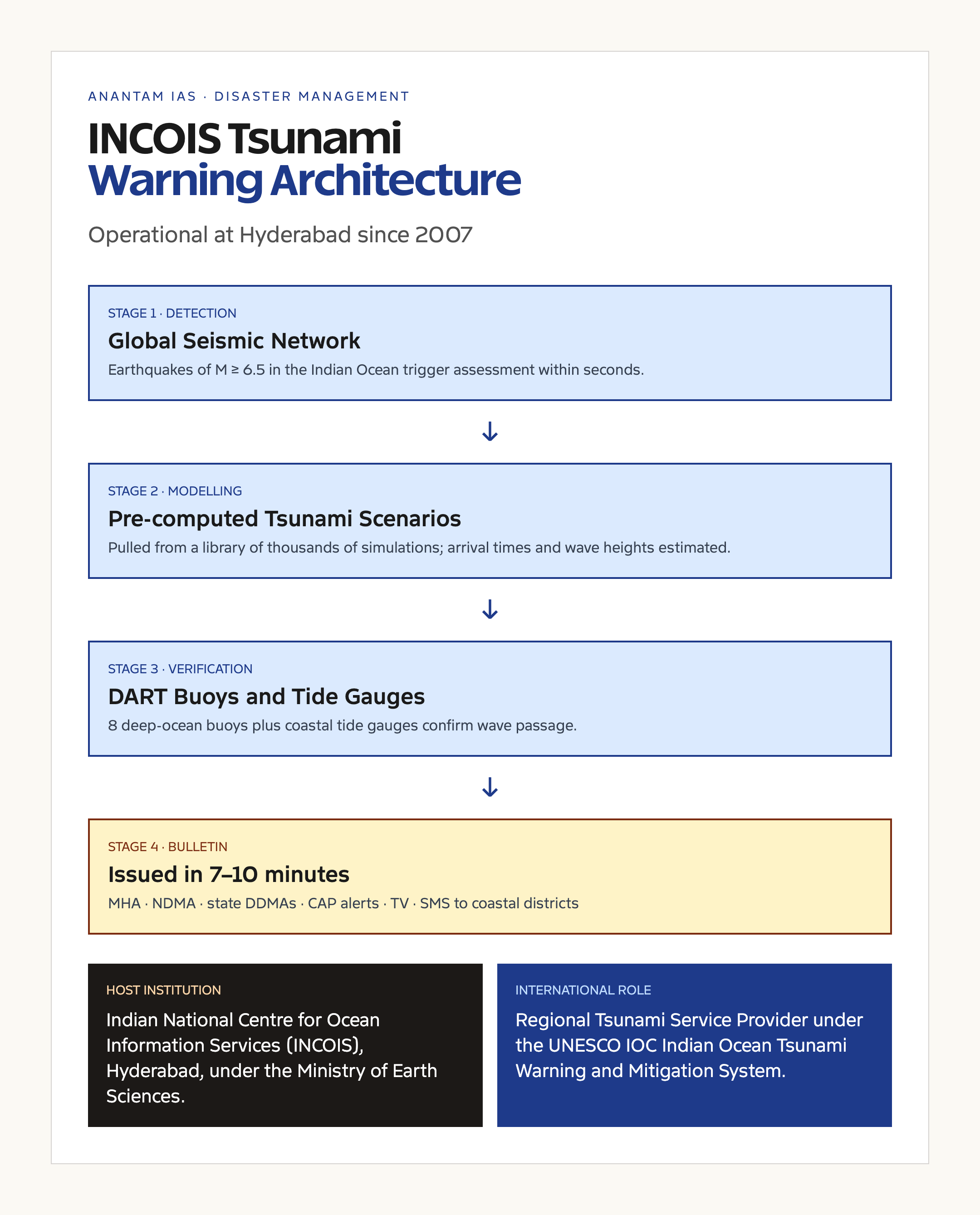
Third, the Indian Tsunami Early Warning Centre (ITEWC) at INCOIS, Hyderabad, was set up in 2007 with French and German collaboration. The centre integrates a network of seismic sensors, deep-ocean assessment and reporting (DART) buoys, tide gauges, and high-performance computing. It issues bulletins in under 10 minutes for any Indian Ocean earthquake with tsunamigenic potential. The centre serves as a Regional Tsunami Service Provider for the Indian Ocean Tsunami Warning and Mitigation System (IOTWMS) under the Intergovernmental Oceanographic Commission of UNESCO.
Detailed Analysis of the Warning System
The Indian Tsunami Early Warning Centre operates as a 24×7 facility. Its workflow runs in stages. First, the global seismic network detects an earthquake. INCOIS receives the data within seconds. Software estimates the magnitude, depth, and location. If the earthquake is a shallow submarine event of magnitude 6.5 or above in the Indian Ocean, a tsunami threat assessment is initiated.
Second, the system models wave propagation using pre-computed scenarios. For each possible earthquake in the Indian Ocean, INCOIS has already run thousands of tsunami simulations. The matching scenario is pulled out, giving arrival times and expected wave heights for the Indian coast.
Third, deep-ocean DART buoys (Bottom Pressure Recorders) detect the actual passage of the tsunami wave in open water. India operates eight such buoys, three of which are in the Bay of Bengal and the remaining in the Arabian Sea and southern Indian Ocean. Tide gauges along the Indian coast and on islands confirm the arrival of the wave.
Fourth, bulletins are issued to the Ministry of Home Affairs, NDMA, state governments, and to the public through SMS, Common Alerting Protocol (CAP), and television. The first bulletin can go out within 10 minutes of the earthquake.
The system was tested in the 2012 Indian Ocean earthquake (magnitude 8.6 off Sumatra), the 2018 Sulawesi event, and several smaller earthquakes. In each case, the warning was issued within 8 to 10 minutes, well within the 30-minute target.
Comparative View: Pacific vs Indian Ocean Tsunami Systems
The Pacific Tsunami Warning Center (PTWC) at Hawaii has been operational since 1949, after the 1946 Aleutian Islands tsunami. The Pacific system has 50 years of experience. The Indian Ocean system is younger, less dense in instrumentation, and serves a much more diverse coastline with shorter warning times for many countries.
Japan has the most advanced tsunami warning capacity, with first warnings sometimes issued within 3 minutes. India’s 8-to-10-minute target is in line with the Australian and Indonesian systems. The 2024 IOTWMS exercise (a region-wide drill) tested response capacity across all 27 member states and found that India’s coastal evacuation preparedness has improved but still varies sharply by state. Tamil Nadu and Odisha rank highly. Andhra and West Bengal lag behind.
Challenges That Remain
Three problems persist.
Last-mile dissemination. A bulletin issued from Hyderabad must reach a fisherman on the Tamil Nadu coast. The chain involves state government, district administration, panchayat, and community siren systems. In 2004, the chain didn’t exist. In 2026, it exists on paper but is patchy in practice. Mock drills regularly show that some fishing villages have functional sirens and trained volunteers, while neighbouring villages have neither.
Tsunamis from non-seismic sources. The Anak Krakatoa eruption in December 2018 generated a tsunami without a preceding earthquake. The Indian Ocean warning system, designed around seismic triggers, did not issue a bulletin. The 2022 Hunga Tonga eruption created similar challenges. INCOIS has been working on adding volcanic and landslide monitoring, but coverage is incomplete.
Coastal regulation. The Coastal Regulation Zone notifications have been progressively diluted since 2011. Construction within the 500-metre high-tide line, banned in many categories, has spread. The next major Indian Ocean tsunami will hit a more built-up coast than in 2004.
Prelims Pointers
- The 2004 earthquake had magnitude Mw 9.1 to 9.3, on the Sunda megathrust off Sumatra.
- The rupture length was approximately 1,300 km.
- India’s death toll was approximately 12,400 dead and 5,640 missing.
- Tamil Nadu lost the most lives, with Nagapattinam the worst-hit district.
- The Andaman and Nicobar Islands subsided in places, with Indira Point (southernmost tip of India) partly submerged.
- The Disaster Management Act 2005 was passed in response and created the NDMA, SDMA, and DDMA framework.
- The Indian Tsunami Early Warning Centre is at INCOIS, Hyderabad, operational since 2007.
- INCOIS is an autonomous body under the Ministry of Earth Sciences.
- India is a Regional Tsunami Service Provider under the Indian Ocean Tsunami Warning and Mitigation System (IOTWMS) of UNESCO IOC.
- The Pacific Tsunami Warning Center is at Hawaii, operational since 1949.
Mains Practice Questions
- “The Indian Ocean Tsunami of 2004 was a humanitarian catastrophe that became a turning point in Indian disaster governance.” Discuss the institutional changes that followed and assess their effectiveness as of 2026. (GS Paper 3, Disaster Management, 250 words)
- Explain the science of a tsunami. Why are submarine megathrust earthquakes the principal trigger, and how does the Indian Tsunami Early Warning Centre at INCOIS detect them? (GS Paper 1, Geography, 250 words)
- “Last-mile dissemination remains the weakest link in India’s tsunami early warning system.” Examine the structural and administrative challenges and suggest reforms. (GS Paper 3, 150 words)
- The 2004 tsunami affected indigenous tribes of the Andaman and Nicobar Islands differently from mainland communities. Discuss the disaster’s impact on tribal society and the policy questions it raised. (GS Paper 1, Indian Society, 250 words)
Way Forward
The two-decade anniversary in December 2024 brought a round of reviews. The IOTWMS exercise in October 2024 found that the warning system is technically robust, with bulletins issued within 7 to 9 minutes of major earthquakes, but the dissemination chain has plateaued. Four reforms are widely supported.
First, integrate the tsunami warning with the Common Alerting Protocol (CAP) used by the Indian Meteorological Department for cyclones in India and by the Ministry of Home Affairs for other hazards. A unified national alerting backbone, rather than several parallel systems, would reduce confusion at the last mile.
Second, fund and maintain the community siren network in every coastal panchayat, with annual mock drills. The cost is modest, the deterrent value is high.
Third, expand the DART buoy network. India lost two buoys to vandalism or technical failure in the past decade. Replacement and additional deployment is overdue.
Fourth, restore the original coastal regulation zone strictness, particularly for tsunami-vulnerable stretches in Tamil Nadu, Andhra Pradesh, and the Andaman group. Building further from the high-tide line is the cheapest possible insurance against the next event.
The Indian Ocean Tsunami of 2004 was a wake-up call that India answered better than most. The institutional architecture that followed is broadly sound. The work now is at the last mile.
Frequently Asked Questions
When did the Indian Ocean Tsunami of 2004 occur?
On 26 December 2004, at 06:28 IST (00:58 UTC). The triggering earthquake was a magnitude 9.1 to 9.3 megathrust event off the west coast of northern Sumatra, Indonesia.
How many people died in India in the 2004 tsunami?
Approximately 12,400 confirmed dead and 5,640 missing, primarily in Tamil Nadu, Andhra Pradesh, Kerala, Puducherry, and the Andaman & Nicobar Islands.
Which Indian state was worst affected by the 2004 tsunami?
Tamil Nadu, with around 8,000 deaths. Nagapattinam district alone accounted for around 6,000.
Why didn’t India have a tsunami warning in 2004?
The Indian Ocean had no tsunami warning system. The Pacific Tsunami Warning Center detected the earthquake but lacked authority and channels to alert Indian Ocean countries. India established the Indian Tsunami Early Warning Centre at INCOIS, Hyderabad, in 2007.
What was the role of INCOIS after the 2004 tsunami?
INCOIS, under the Ministry of Earth Sciences, runs the Indian Tsunami Early Warning Centre. It integrates seismic data, DART buoys, and tide gauges, and issues bulletins within 7 to 10 minutes of significant Indian Ocean earthquakes. India is a Regional Tsunami Service Provider under the IOTWMS.
What is the Disaster Management Act 2005?
The Disaster Management Act 2005 was enacted in December 2005, after the tsunami. It created the National Disaster Management Authority (NDMA), State Disaster Management Authorities, and District Disaster Management Authorities. The Act forms the statutory framework for disaster management in India.
How did the Andaman and Nicobar Islands fare in the tsunami?
Around 3,500 dead and missing, with several islands subsiding by metres. Indira Point, the southernmost tip of India, was partly submerged. Tribal communities including the Nicobarese suffered heavy losses. The Sentinelese appear to have survived through their inland location and traditional knowledge.
What is the difference between a tsunami and a tidal wave?
A tsunami is a series of ocean waves caused by sudden vertical displacement of water, typically from a submarine earthquake. A tidal wave is a wave caused by the gravitational pull of the sun and moon. The terms are not interchangeable.
Can a tsunami strike the same coast again?
Yes. The Sunda megathrust ruptured in 1797, 1833, and 2004. Strain is again accumulating. The next major event is a question of when, not if, although the timing cannot be predicted.
What is the warning time for a tsunami on India’s east coast?
Approximately 2 hours from a Sumatra-region earthquake. The Andaman and Nicobar Islands have only 15 to 20 minutes of warning because of their proximity. The Bay of Bengal and Arabian Sea early-warning network is designed around these time windows.
Tell Google you want more of this.
Add Anantam IAS as a preferred sourceOne tap, and this site shows up more often in your own Top Stories, AI Overviews and AI Mode. Remove it any time.