


The longest dam in India is the Hirakud Dam, built across the Mahanadi River in Sambalpur district of Odisha. With a total length of about 4.8 kilometres (25.8 km including earthen dykes) and commissioned in 1957, it was also one of the first major multipurpose river valley projects of independent India. Understanding Hirakud, the classification of dams, and the comparative data of India’s longest and tallest dams is essential for UPSC aspirants because these facts recur in Prelims and in Mains discussions on water resources, inter-state river disputes, and post-independence planning.
Hirakud Dam at a Glance
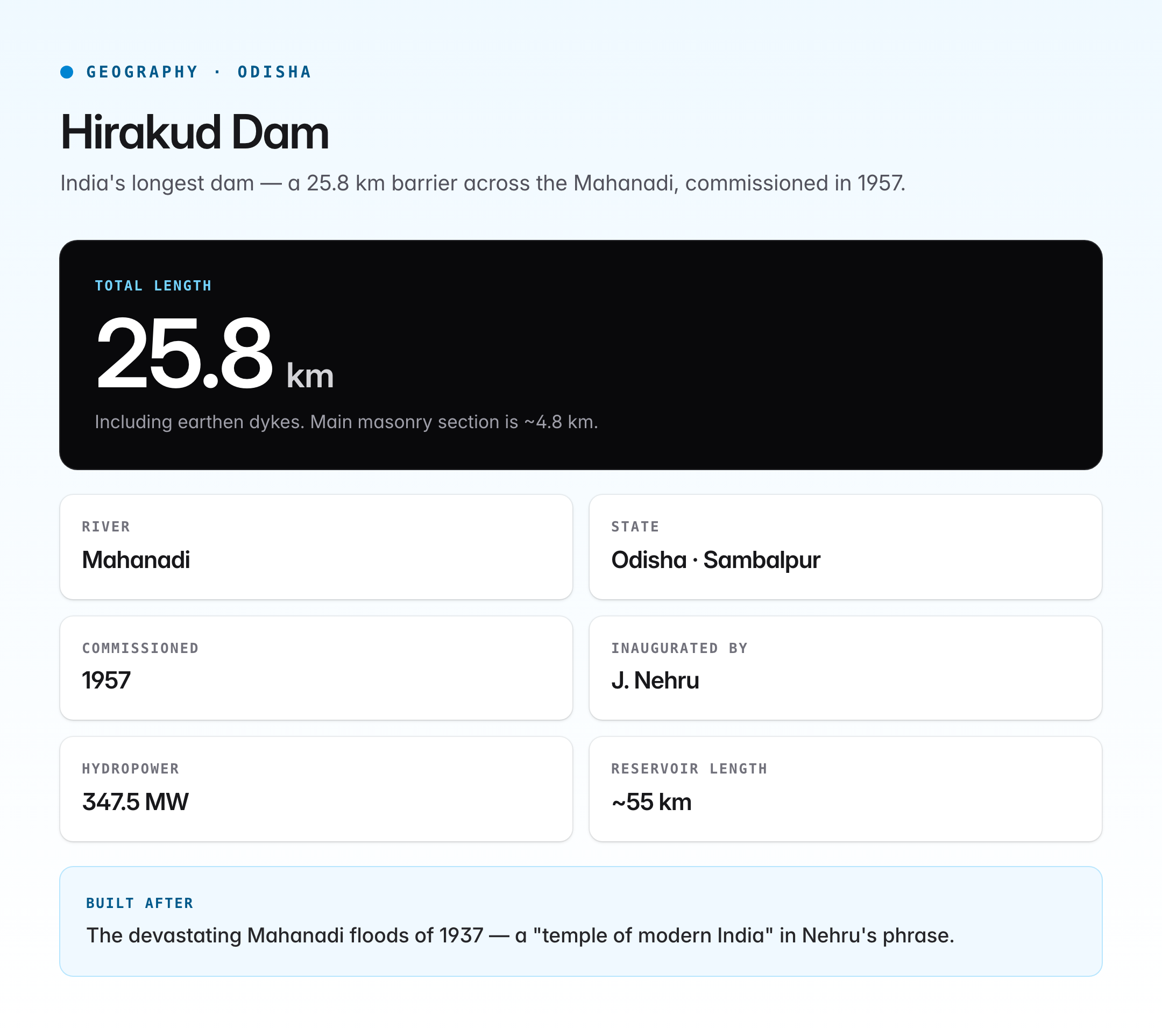
| Feature | Detail |
|---|---|
| River | Mahanadi |
| State | Odisha |
| District | Sambalpur |
| Year commissioned | 1957 |
| Inaugurated by | Jawaharlal Nehru |
| Total length (with dykes) | ~25.8 km |
| Main masonry dam length | ~4.8 km |
| Reservoir | Hirakud Reservoir (one of the longest artificial lakes in Asia, ~55 km long) |
| Installed capacity | ~347.5 MW (hydropower) |
| Purpose | Flood control, irrigation, hydropower, navigation |
The dam was conceived after the devastating Mahanadi floods of 1937. Sir M. Visvesvaraya's preliminary studies and the post-independence push under the Damodar–Mahanadi model of river valley development led to the project's construction between 1948 and 1957. It was part of the first wave of multipurpose projects often described by Nehru as the "temples of modern India."
Why Hirakud Is Called the Longest Dam
Dam length is measured along the crest of the structure from one abutment to the other, including masonry sections and earthen dykes that form the full containment barrier. Hirakud's main dam is a composite structure of masonry and earth, flanked by two long earthen dykes, the Laxmi Dyke on the left and the Chipilima Dyke on the right. When the earthen dykes are included, the total length crosses 25 km, making it by far the longest dam (and second-longest in the world) by overall embankment length. Even measured by main dam alone, its 4.8-km span surpasses every other large dam in India.
Major Dams in India by Length
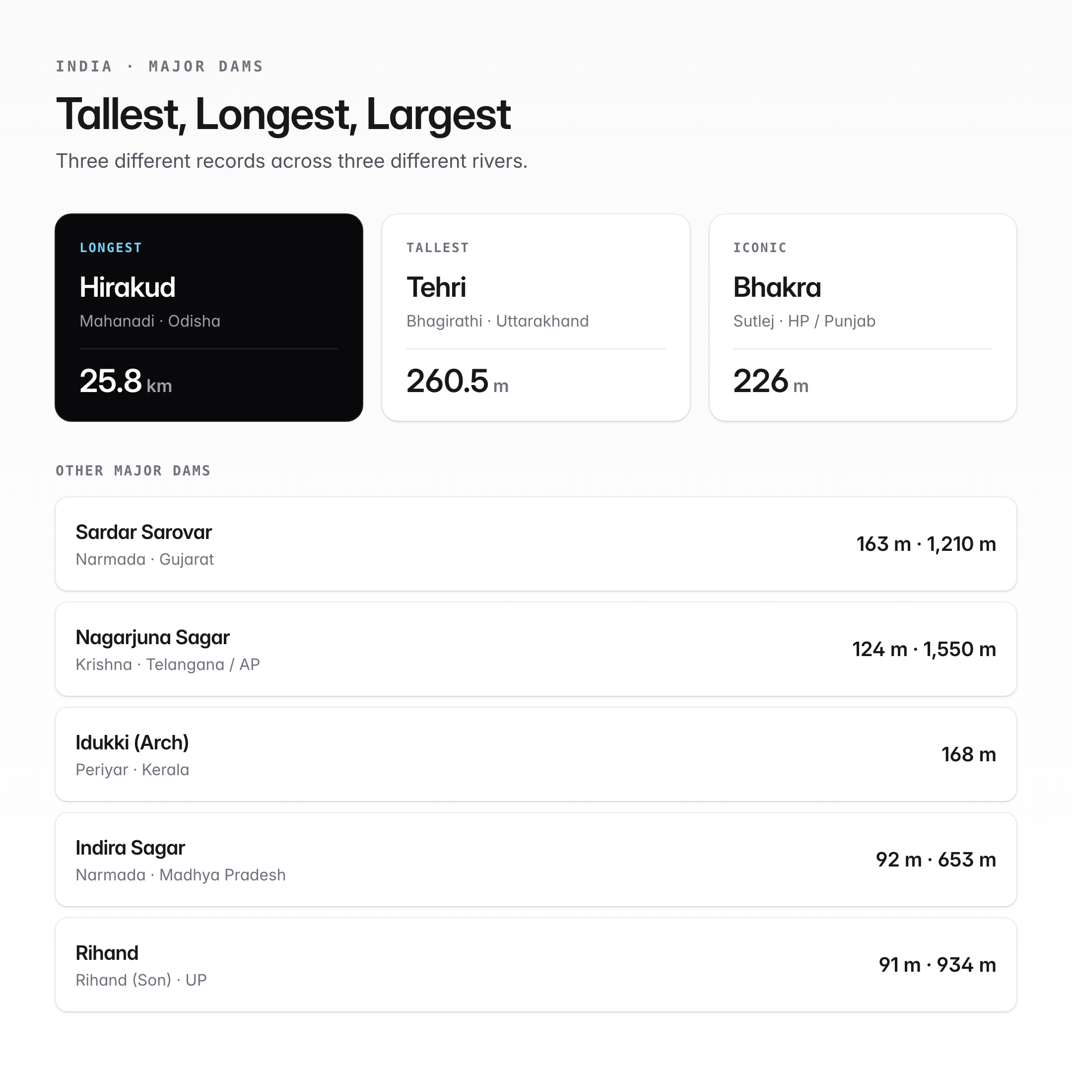
| Dam | River | State | Length (approx) |
|---|---|---|---|
| Hirakud Dam | Mahanadi | Odisha | ~25.8 km (with dykes) / ~4.8 km main |
| Indira Sagar Dam | Narmada | Madhya Pradesh | ~653 m |
| Bhakra Dam | Sutlej | Himachal Pradesh / Punjab border | ~520 m |
| Nagarjuna Sagar Dam | Krishna | Telangana / Andhra Pradesh | ~1,550 m (masonry) |
| Sardar Sarovar Dam | Narmada | Gujarat | ~1,210 m |
| Tehri Dam | Bhagirathi | Uttarakhand | ~575 m |
| Rihand Dam | Rihand (Son tributary) | Uttar Pradesh | ~934 m |
Major Dams in India by Height
| Dam | River | State | Height (approx) |
|---|---|---|---|
| Tehri Dam | Bhagirathi | Uttarakhand | 260.5 m (tallest in India) |
| Bhakra Dam | Sutlej | HP/Punjab | 226 m |
| Sardar Sarovar Dam | Narmada | Gujarat | 163 m |
| Srisailam Dam | Krishna | Andhra Pradesh | 145 m |
| Nagarjuna Sagar Dam | Krishna | Telangana/AP | 124 m |
| Idukki Dam | Periyar | Kerala | 168 m (arch dam) |
| Hirakud Dam | Mahanadi | Odisha | ~60 m |
Tehri Dam is the tallest dam in India and among the tallest in the world. Bhakra Dam is the second tallest and historically the most iconic of Nehru-era projects.
Types of Dams
Dams are classified by construction material and structural behaviour. UPSC Prelims often tests the basic typology.
1. Gravity Dam
A solid concrete or masonry wall that resists the horizontal push of water purely by its own weight. Example: Bhakra Dam (concrete gravity), Hirakud Dam (masonry gravity with earthen flanks).
2. Arch Dam
A curved concrete dam whose horizontal arch transfers water pressure to rocky abutments on either side. Best for narrow, steep-walled gorges. Example: Idukki Dam on the Periyar in Kerala, one of Asia's largest arch dams.
3. Embankment (Earth-Fill or Rock-Fill) Dam
A trapezoidal bank of compacted earth or rock with an impermeable core. Cheaper but bulkier. Example: Tehri Dam (earth-rockfill), Nagarjuna Sagar (masonry with earthen flanks).
4. Buttress Dam
A thin concrete slab held upright by triangular concrete buttresses on the downstream side. Uses less material than a gravity dam. Example: Stone-buttress designs in some medium dams.
5. Barrage
A low-height diversion structure with gates to regulate flow rather than store large volumes. Example: Farakka Barrage, Kota Barrage on the Chambal.
Summary Table
| Type | Key principle | Indian example |
|---|---|---|
| Gravity | Weight resists water pressure | Bhakra, Hirakud |
| Arch | Arch transfers load to abutments | Idukki |
| Embankment | Earth/rock fill with core | Tehri, Mettur |
| Buttress | Slab supported by buttresses | Bhatsa (partial) |
| Barrage | Gated diversion, low storage | Farakka, Kota |
Why Multipurpose Dams Matter
Dams such as Hirakud serve multiple functions, reflecting the multi-purpose river valley project philosophy.
- Flood control on flood-prone deltas like the Mahanadi.
- Irrigation of millions of hectares.
- Hydropower, a clean renewable source.
- Domestic and industrial water supply.
- Navigation on regulated reaches.
- Fisheries in reservoir lakes.
- Recreation and tourism.
However, large dams also cause displacement, deforestation, reservoir-induced seismicity, siltation, methane emissions from submerged biomass, and disruption of river ecology. The Narmada Bachao Andolan and the World Commission on Dams (2000) highlighted these costs.
Hirakud's Role in Floods and Disputes
Hirakud has significantly reduced downstream flooding in coastal Odisha, though 2008 and 2011 floods showed limits under extreme monsoons. The dam is also central to the Mahanadi water dispute between Odisha and Chhattisgarh, where upstream barrages in Chhattisgarh are alleged to reduce flows to Hirakud. The Mahanadi Water Disputes Tribunal was constituted in 2018 under the Inter-State River Water Disputes Act, 1956.
Siltation and Climate Pressures
Like most old Indian dams, Hirakud faces reservoir siltation that reduces live storage over decades. Climate change is altering monsoon timing and intensity, putting additional stress on design assumptions. The Central Water Commission’s periodic sedimentation surveys guide desilting, catchment-area treatment, and revised rule curves.
UPSC Relevance
The longest dam in India is a frequent Prelims factual question, as are related points on Tehri (tallest dam), Bhakra, Sardar Sarovar, and the river–state–dam matching format. For GS Paper I, Hirakud connects to the physical geography of the Mahanadi basin, the distribution of rivers in India, and the physiography of peninsular plateaus. In GS Paper II and III, it links to inter-state river water disputes, federalism and cooperative federalism, food security through irrigation, and hydropower in the energy mix. Mains answers should weigh the economic benefits against social and ecological costs using frameworks such as the Narmada Bachao Andolan, the World Commission on Dams, and the Environmental Impact Assessment (EIA) Notification. In Essay and Ethics, dam-building is a classic case of weighing development against displacement — a theme aspirants can illustrate with Hirakud's own history of submergence of villages and the ongoing Mahanadi dispute.
Tell Google you want more of this.
Add Anantam IAS as a preferred sourceOne tap, and this site shows up more often in your own Top Stories, AI Overviews and AI Mode. Remove it any time.






