Satellite-based technologies in agriculture now underpin almost every major decision the Indian state makes about food, from procurement targets to crop insurance payouts. Remote sensing in agriculture works because it solves an observation problem nothing else can solve affordably: monitoring roughly 140 million hectares of net sown area, field by field, week after week. India’s advantage is that it owns the constellation rather than renting it.
What Satellites Actually Measure
- Optical and multispectral imagery for crop discrimination and vegetation vigour, using indices such as NDVI (greenness and biomass) and NDWI (moisture content).
- Synthetic aperture radar, which penetrates cloud and is therefore the only reliable option during the monsoon.
- Thermal infrared for land surface temperature, evapotranspiration and crop water stress.
- Microwave for soil moisture in the root zone.
- Hyperspectral for nutrient and disease signatures at finer spectral resolution.
The Operational Systems in India
| System | What it does |
|---|---|
| FASAL | Forecasting Agricultural output using Space, Agro-meteorology and Land-based observations, for pre-harvest acreage and yield estimates |
| KRISHI-DSS | Decision support system integrating crop, soil, weather and water layers, launched 2024 |
| NADAMS | National Agricultural Drought Assessment and Monitoring System |
| CHAMAN | Coordinated Horticulture Assessment and Management using geoinformatics |
| Bhuvan | ISRO geoportal hosting wasteland, soil, land-use and groundwater-prospect layers |
| PMFBY YES-TECH | Remote-sensing-based yield estimation to reduce dependence on crop-cutting experiments |
| Gramin Krishi Mausam Sewa | Block-level agro-advisories built on IMD forecasts, delivered by SMS and app |
The Satellites Doing the Work
- RISAT series: C-band radar, all-weather imaging, critical for kharif monitoring and flood mapping.
- Resourcesat series: the workhorse for multispectral crop-area estimation.
- INSAT-3DS: meteorological observation feeding IMD forecasts and agro-advisories.
- EOS-08: recent earth observation capacity.
- NISAR: the NASA-ISRO dual-band L and S radar mission, giving all-weather soil moisture and biomass measurement.
- TRISHNA: the India-France thermal infrared mission designed for high-resolution evapotranspiration and crop water stress.
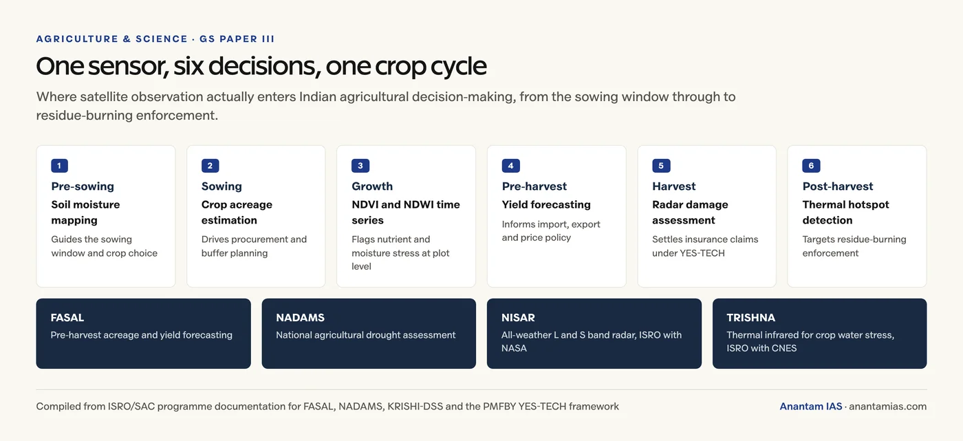
Applications Across the Crop Cycle
- Pre-sowing: soil moisture and residual-moisture mapping to guide sowing windows and crop choice.
- Sowing: acreage estimation by crop, which drives procurement and buffer planning.
- Growth: NDVI time series to flag nutrient and moisture stress at plot level; pest and disease early warning.
- Pre-harvest: yield forecasting for import, export and price policy.
- Post-harvest: damage assessment for insurance, and residue-burning hotspot detection for enforcement.
Why It Matters for Food Security
Food security is conventionally assessed on four dimensions, and satellite data touches all four.
- Availability: better acreage and yield forecasts improve procurement and buffer stocking.
- Access: faster insurance settlement and timely advisory prevent distress sales and debt.
- Stability: drought and flood early warning reduce the shock from a bad season.
- Utilisation: site-specific nutrient advice supports better nutrient content in what is grown.
The wider policy frame is in our notes on climate-smart agriculture and food security in India.
The Honest Limits
- Small holdings. India’s average operational holding is about 1.08 hectares. Mixed pixels limit plot-level accuracy on the smallest farms, which are exactly the ones with the least margin for error.
- Cloud cover. Optical sensors are defeated during the monsoon, which is when flood and pest information is most needed. Radar is the answer, and radar capacity is scarcer.
- The last mile. A satellite product that never reaches the farmer in a usable language, through a device they own, changes nothing. Extension capacity, not observation quality, is the binding constraint.
- Ground truthing. Models still need field validation, and the crop-cutting experiment has not disappeared.
- Data governance. Farm-level data ownership, consent and commercial reuse remain unsettled questions under AgriStack.
Frequently Asked Questions
How is remote sensing used in Indian agriculture?
It is used for crop acreage and yield forecasting under FASAL and KRISHI-DSS, drought assessment under NADAMS, horticulture assessment under CHAMAN, crop insurance yield estimation under PMFBY’s YES-TECH framework, and block-level agro-advisories through the Gramin Krishi Mausam Sewa.
What is NDVI and why does it matter for crops?
NDVI is the Normalised Difference Vegetation Index, calculated from red and near-infrared reflectance. Healthy vegetation reflects strongly in the near infrared and absorbs red light, so NDVI is a proxy for greenness and biomass. Time series of NDVI reveal nutrient and moisture stress before it is visible on the ground.
Why is radar imagery important for Indian agriculture?
Because optical sensors cannot see through monsoon cloud, and the monsoon is exactly when flood mapping and kharif crop monitoring matter most. Synthetic aperture radar penetrates cloud, which is why RISAT and now the NASA-ISRO NISAR mission are central to all-weather monitoring.
What is the YES-TECH framework under PMFBY?
It is the technology-based yield estimation system for the Pradhan Mantri Fasal Bima Yojana, using remote sensing to reduce dependence on slow and dispute-prone crop-cutting experiments. It shortens claim settlement time and reduces assessment disputes.
What is TRISHNA and how does it help farming?
TRISHNA is a joint India-France thermal infrared mission designed to measure land surface temperature at high resolution. That allows accurate estimation of evapotranspiration and crop water stress, which supports irrigation scheduling and drought monitoring.
What limits satellite technology in Indian agriculture?
The average operational holding is about 1.08 hectares, so mixed pixels limit plot-level accuracy on small farms. Monsoon cloud defeats optical sensors, ground truthing is still required, and the biggest constraint is the extension system that has to turn the data into a decision in a farmer’s field.
Practice Questions
Prelims MCQs
1. FASAL, in the context of Indian agriculture, relates to:
- (a) Fertiliser subsidy allocation
- (b) Crop forecasting using space and agro-meteorological data
- (c) Farm loan waivers
- (d) Food storage logistics
Answer: (b) Crop forecasting using space and agro-meteorological data
2. NDVI is computed using reflectance in which bands?
- (a) Blue and green
- (b) Red and near-infrared
- (c) Thermal and microwave
- (d) Ultraviolet and blue
Answer: (b) Red and near-infrared
3. The main advantage of synthetic aperture radar over optical sensors in agriculture is that it:
- (a) Has higher spectral resolution
- (b) Can image through cloud cover
- (c) Is cheaper to operate
- (d) Measures soil chemistry directly
Answer: (b) Can image through cloud cover
4. NISAR is a joint mission between ISRO and:
- (a) ESA
- (b) JAXA
- (c) NASA
- (d) CNES
Answer: (c) NASA
5. The YES-TECH framework is associated with which scheme?
- (a) PM-KISAN
- (b) PM Fasal Bima Yojana
- (c) Soil Health Card Scheme
- (d) e-NAM
Answer: (b) PM Fasal Bima Yojana
Mains Questions
- Analyze the role of satellite-based technologies in achieving climate-smart agriculture and food security in India.
- “The constraint in Indian agriculture is no longer the quality of the observation but the strength of the extension system.” Examine.
- Discuss the applications of remote sensing across the crop cycle, from sowing to post-harvest assessment.
- Evaluate the use of technology-based yield estimation in crop insurance, with reference to PMFBY.
- Examine the challenges of applying satellite technology to a smallholder-dominated agricultural economy.
Tell Google you want more of this.
Add Anantam IAS as a preferred sourceOne tap, and this site shows up more often in your own Top Stories, AI Overviews and AI Mode. Remove it any time.