

A soil profile is a vertical cross-section of the soil from the surface down to the unweathered parent rock. It reveals distinct layers called horizons, each with characteristic colour, texture, structure, and composition. Understanding soil profiles is fundamental to geography and agriculture, and it is a recurring topic in UPSC Prelims and Mains — particularly in the context of Indian soil types, their distribution, and conservation.
What Is a Soil Profile?
When a vertical trench is dug into the ground, the exposed face shows a sequence of layers that differ in colour, composition, and texture. This sequence is the soil profile. Each layer is called a soil horizon. The study of soil profiles is part of pedology (soil science), and it helps geographers, agronomists, and environmental scientists understand soil fertility, drainage, and land-use potential.
Soil Horizons
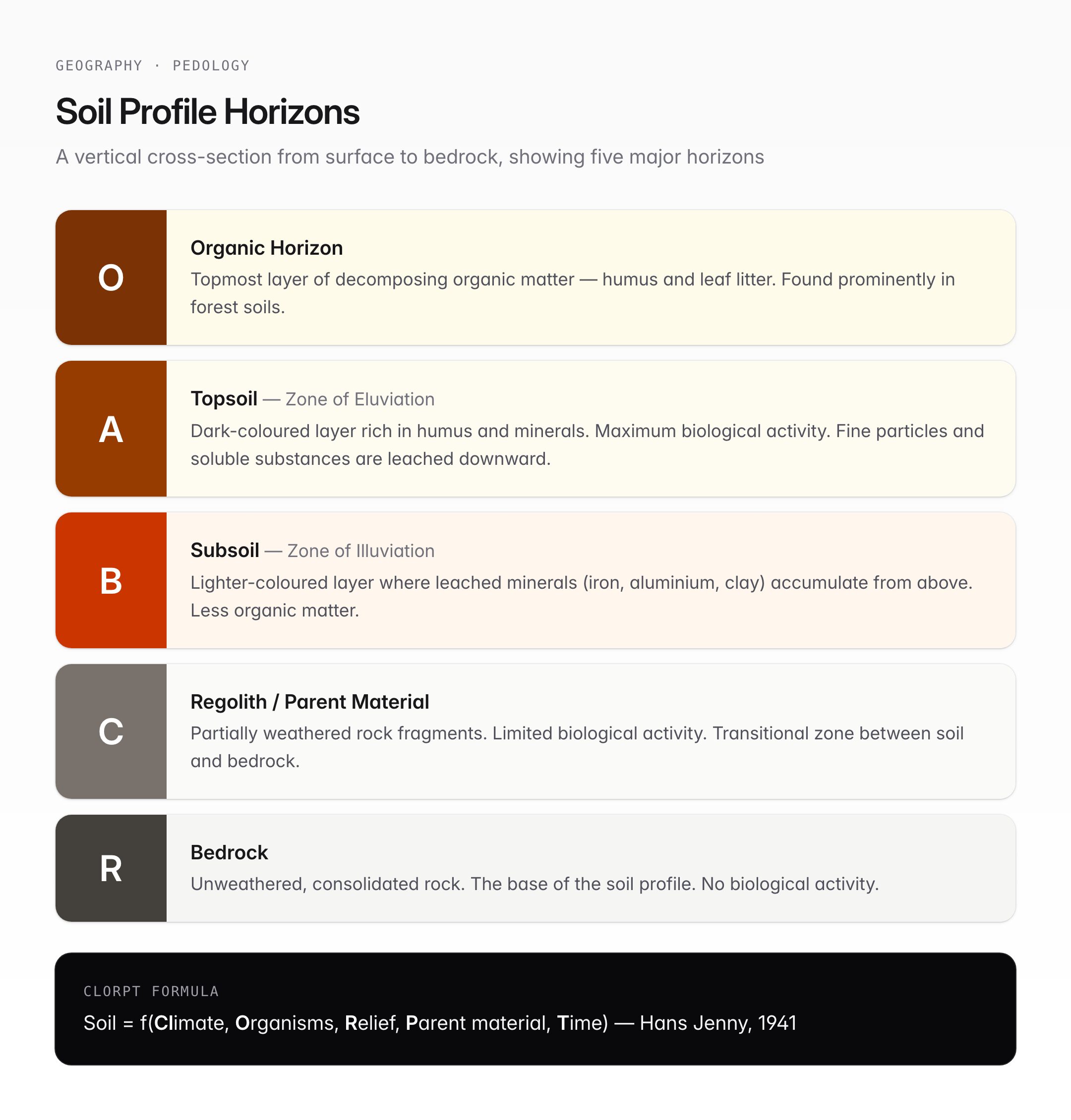
The standard soil profile comprises five major horizons, designated by letters:
| Horizon | Name | Description |
|---|---|---|
| O | Organic horizon | Topmost layer of decomposing organic matter (humus, leaf litter). Found prominently in forest soils. |
| A | Topsoil | Dark-coloured layer rich in humus and minerals. Zone of maximum biological activity. Also called the zone of eluviation (leaching). |
| B | Subsoil | Lighter-coloured layer where leached minerals (iron, aluminium, clay) accumulate. Called the zone of illuviation. |
| C | Regolith / Parent material | Partially weathered rock fragments. Limited biological activity. Transitional between soil and bedrock. |
| R | Bedrock | Unweathered, consolidated rock. The base of the soil profile. |
Key terms:
- Eluviation — The washing out of fine particles and soluble substances from the A horizon by percolating water.
- Illuviation — The deposition of these leached materials in the B horizon.
- Humus — Decomposed organic matter that gives topsoil its dark colour and improves fertility.
Soil Formation Factors — CLORPT
The formation of soil is governed by five factors, remembered by the mnemonic CLORPT, proposed by soil scientist Hans Jenny (1941):
| Factor | Role in Soil Formation |
|---|---|
| Cl — Climate | Temperature and rainfall control the rate of weathering and organic decomposition. Tropical climates produce deeply weathered soils (laterite). |
| O — Organisms | Plants, animals, bacteria, and fungi contribute organic matter and aid in mixing and aeration. Earthworms are called "nature's ploughmen." |
| R — Relief (Topography) | Slope angle and aspect affect drainage, erosion, and soil depth. Flat areas accumulate deeper soils; steep slopes lose soil to erosion. |
| P — Parent material | The mineral composition of the underlying rock determines soil chemistry. Basalt produces black soil; granite produces red/sandy soil. |
| T — Time | Older soils are more developed with distinct horizons. Young soils (alluvial deposits) may lack clear horizon differentiation. |
Major Soil Types of India
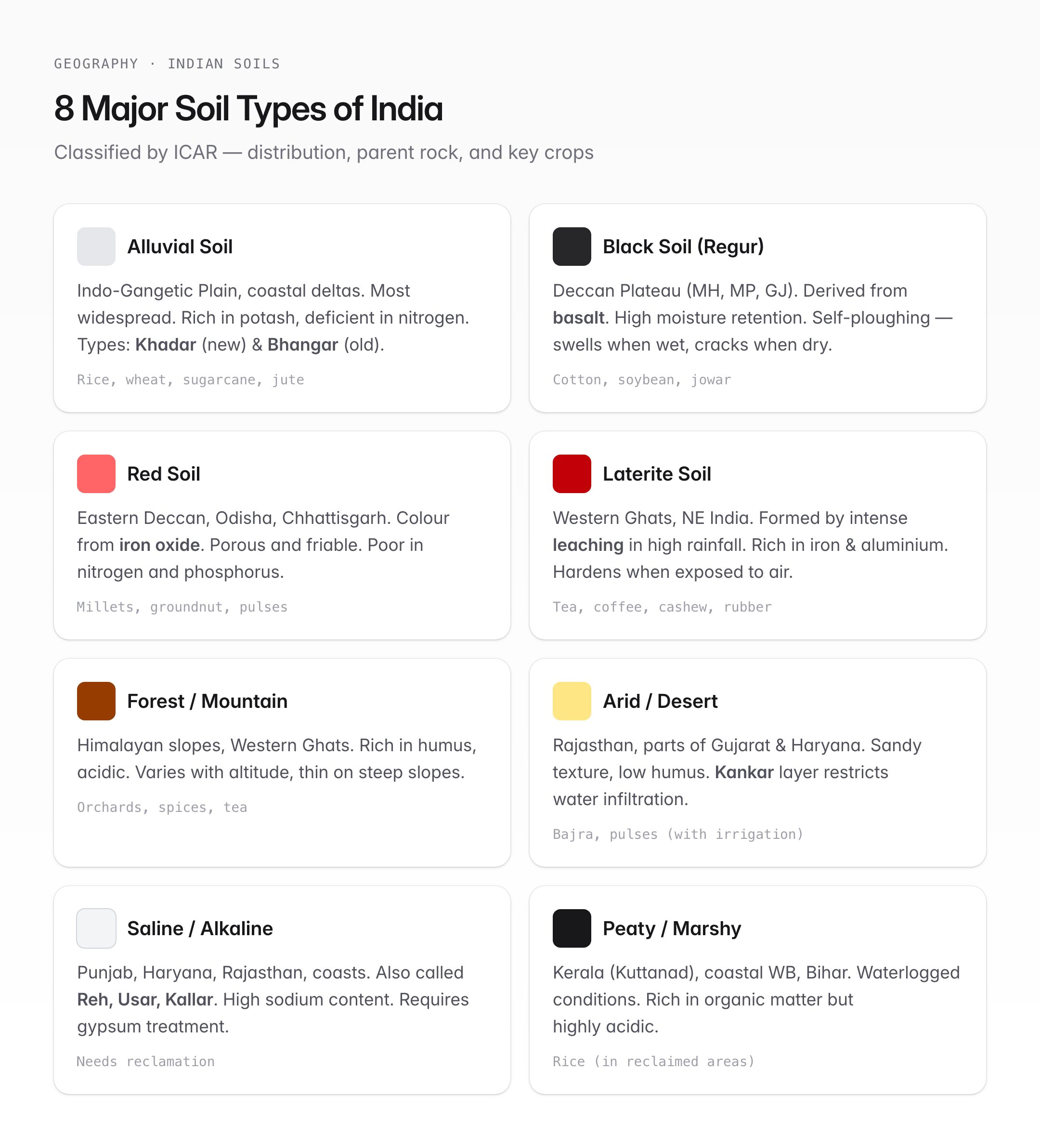
India's diverse climate, topography, and geology produce a wide range of soil types. The Indian Council of Agricultural Research (ICAR) classifies Indian soils into eight major types:
| Soil Type | Colour | Region | Key Characteristics | Major Crops |
|---|---|---|---|---|
| Alluvial | Light grey to ash | Indo-Gangetic Plain, coastal deltas | Most widespread; rich in potash, deficient in nitrogen and phosphorus; two types — Khadar (new) and Bhangar (old) | Rice, wheat, sugarcane, jute |
| Black (Regur) | Dark grey to black | Deccan Plateau (Maharashtra, MP, Gujarat) | Derived from basalt; rich in calcium, magnesium, iron; high moisture retention; self-ploughing (swells when wet, cracks when dry) | Cotton (hence "black cotton soil"), soybean, jowar |
| Red | Red to yellow | Eastern Deccan, Odisha, Chhattisgarh | Colour due to iron oxide; generally poor in nitrogen, phosphorus, and humus; porous and friable | Millets, groundnut, pulses |
| Laterite | Brick red | Western Ghats, NE India, parts of Odisha | Formed by intense leaching in high rainfall areas; rich in iron and aluminium; poor in nitrogen and potash; hardens when exposed to air | Tea, coffee, cashew, rubber |
| Forest/Mountain | Dark brown | Himalayan slopes, Western Ghats upper reaches | Rich in humus; acidic; varies with altitude; thin on steep slopes | Orchards, spices, tea |
| Arid/Desert | Sandy, light brown | Rajasthan, parts of Gujarat and Haryana | Sandy texture; low humus and moisture; high salt content; kankar (calcium carbonate) layer restricts water infiltration | Bajra, pulses (with irrigation) |
| Saline/Alkaline | White crust on surface | Punjab, Haryana, Rajasthan, coastal areas | Also called Reh, Usar, or Kallar; high sodium, potassium, magnesium; unsuitable for agriculture without reclamation | Requires gypsum treatment for cultivation |
| Peaty/Marshy | Dark, black | Kerala (Kuttanad), coastal West Bengal, parts of Bihar | Formed in waterlogged conditions; rich in organic matter but highly acidic; poor aeration | Rice (in reclaimed areas) |
Soil Conservation Methods
Soil erosion — the removal of topsoil by wind, water, or human activity — is a major challenge in India. Key conservation methods include:
Biological Methods
- Afforestation and reforestation — Tree cover reduces the impact of rain on soil and binds soil with roots.
- Contour ploughing — Ploughing along contour lines reduces water runoff on slopes.
- Strip cropping — Alternating strips of different crops break wind and water flow.
- Crop rotation — Alternating crops maintains soil fertility and structure.
- Mulching — Covering soil with organic material reduces evaporation and erosion.
Engineering Methods
- Terrace farming — Cutting steps into hillsides reduces slope length and runoff speed. Common in Himalayan states.
- Check dams and gully plugs — Small barriers across drainage channels slow water and trap sediment.
- Contour bunding — Earthen embankments along contours prevent water from flowing downhill.
- Shelter belts / Windbreaks — Rows of trees planted perpendicular to wind direction reduce wind erosion. Used extensively in the Thar Desert region.
Institutional Efforts
- National Mission for Green India — Aims to increase forest cover and improve degraded land.
- Soil Health Card Scheme (2015) — Provides farmers with information on nutrient status and recommendations for appropriate fertiliser use.
- Pradhan Mantri Krishi Sinchayee Yojana (PMKSY) — Promotes efficient water use, reducing waterlogging and salinisation.
UPSC Relevance
GS Paper I — Geography: Geomorphology; distribution of key natural resources; factors responsible for the location of industries (soil-dependent agriculture).
GS Paper III — Agriculture: Soil health; land reforms; conservation of resources.
Prelims key facts:
- A soil profile has five horizons: O, A, B, C, R (top to bottom).
- The A horizon is the zone of eluviation; the B horizon is the zone of illuviation.
- CLORPT stands for Climate, Organisms, Relief, Parent material, Time.
- Alluvial soil is the most widespread soil in India, covering the entire Indo-Gangetic Plain.
- Black soil (Regur) is derived from basalt and is ideal for cotton cultivation.
- Laterite soil forms through intense leaching and is rich in iron and aluminium but poor in fertility.
- Khadar (new alluvium) is more fertile than Bhangar (old alluvium).
- The Soil Health Card Scheme was launched in 2015.
- Contour ploughing, terrace farming, and shelter belts are key soil conservation techniques for UPSC.
Tell Google you want more of this.
Add Anantam IAS as a preferred sourceOne tap, and this site shows up more often in your own Top Stories, AI Overviews and AI Mode. Remove it any time.






