India receives about 4,000 billion cubic metres of precipitation annually, yet faces a deepening water crisis. With 18% of the world's population but only 4% of global freshwater resources, the country's water management is a critical governance challenge. For UPSC, water resources appear across Geography, Environment, and Governance papers — covering river systems, dam projects, inter-state disputes, and policy frameworks.
Overview of India's Water Resources
India's total water availability is estimated at about 1,999 billion cubic metres (BCM) from precipitation and snowmelt. However, only about 1,123 BCM is utilisable — 690 BCM from surface water and 433 BCM from groundwater. The gap between total availability and actual use reflects losses to evaporation, runoff to the sea, and recharge limitations.
Sources of Water
| Source | Contribution | Key Facts |
|---|---|---|
| Rivers | ~690 BCM (surface) | 12 major river basins, numerous tributaries |
| Groundwater | ~433 BCM (utilisable) | India is the world's largest groundwater user |
| Rainfall | ~4,000 BCM total | ~75% falls during June-September monsoon |
| Glaciers | Feeds Himalayan rivers | Gangotri, Siachen, and others under climate stress |
| Lakes & Wetlands | Limited but important | Wular, Chilika, Loktak, Dal Lake |
India extracts more groundwater than any other country — approximately 250 BCM annually, exceeding the combined extraction of the United States and China.
Major River Systems and Their Water Potential
India's rivers are broadly classified into Himalayan and Peninsular systems. The Himalayan rivers are perennial (fed by both glaciers and rainfall), while most Peninsular rivers are rain-fed and seasonal.
Himalayan Rivers: Water Potential
| River Basin | Basin Area (sq km) | Average Annual Flow (BCM) |
|---|---|---|
| Ganga-Yamuna-Brahmaputra | ~1,086,000 | ~525 |
| Indus (Indian portion) | ~321,000 | ~73 |
Peninsular Rivers: Water Potential
| River Basin | Basin Area (sq km) | Average Annual Flow (BCM) |
|---|---|---|
| Godavari | ~312,812 | ~110 |
| Krishna | ~258,948 | ~78 |
| Mahanadi | ~141,589 | ~67 |
| Narmada | ~98,796 | ~46 |
| Cauvery | ~81,155 | ~21 |
| Tapi | ~65,145 | ~15 |
The Brahmaputra basin alone carries nearly 30% of India's total river water but serves only 5% of the population — highlighting massive regional disparity.
Related: River Systems of India: Himalayan & Peninsular
Dams and Reservoirs of India
India has over 5,700 large dams — the third-highest count globally after China and the United States. These dams serve multiple purposes: irrigation, hydropower generation, flood control, and drinking water supply.
Major Dams of India
| Dam | River | State | Purpose |
|---|---|---|---|
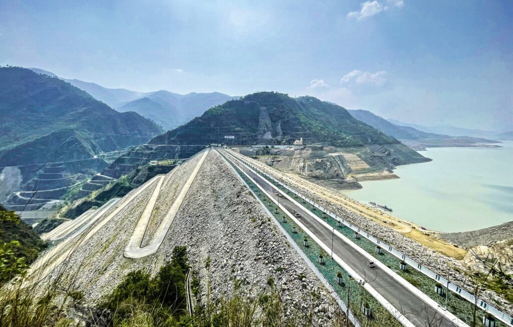
| Tehri Dam | Bhagirathi | Uttarakhand | Highest dam in India (260.5 m); hydropower, irrigation |
| Bhakra Nangal Dam | Sutlej | Himachal Pradesh-Punjab border | Irrigation, hydropower; Gobind Sagar reservoir |
| Hirakud Dam | Mahanadi | Odisha | Longest dam in India (~25.8 km with dykes); flood control |
| Sardar Sarovar Dam | Narmada | Gujarat | Irrigation, drinking water for Gujarat; controversial displacement |
| Nagarjuna Sagar Dam | Krishna | Telangana-Andhra Pradesh | One of the world's largest masonry dams; irrigation |
| Mettur Dam | Cauvery | Tamil Nadu | Built in 1934; irrigation for Cauvery delta |
| Tungabhadra Dam | Tungabhadra | Karnataka-Andhra Pradesh | Irrigation for Rayalaseema and Bellary districts |
| Idukki Dam | Periyar | Kerala | Arch dam; hydropower |
| Koyna Dam | Koyna | Maharashtra | Major hydropower; 1967 reservoir-induced earthquake |
Dam Safety Act, 2021
The Dam Safety Act, 2021 established the National Committee on Dam Safety (NCDS) and the National Dam Safety Authority (NDSA). Over 200 dams in India are more than 100 years old, and structural deterioration poses risks to downstream populations. The Act mandates regular inspection, emergency action plans, and maintenance protocols.
Irrigation in India
Irrigation is the largest consumer of India's water — accounting for about 80% of freshwater use. Despite decades of investment, only about 52% of the net sown area is irrigated; the remainder depends on rainfall.
Types of Irrigation
| Type | Coverage | Region |
|---|---|---|
| Canal Irrigation | ~24% of net irrigated area | Punjab, Haryana, UP, Rajasthan |
| Well/Tubewell Irrigation | ~62% of net irrigated area | Indo-Gangetic plain, Maharashtra, Tamil Nadu |
| Tank Irrigation | ~3% of net irrigated area | Tamil Nadu, Andhra Pradesh, Karnataka |
| Other Sources | ~11% | Sprinkler, drip, lift irrigation |
The dominance of groundwater irrigation (wells and tubewells) explains India's groundwater depletion crisis. States like Punjab, Haryana, and Rajasthan extract far more than the natural recharge rate.
Major Irrigation Projects
- Indira Gandhi Canal — brings Sutlej-Beas waters to the Thar Desert in Rajasthan; longest canal in India
- Bhakra-Nangal System — irrigates Punjab, Haryana, and Rajasthan
- Narmada Canal — part of Sardar Sarovar Project; serves drought-prone areas of Gujarat and Rajasthan
- Kosi Project — flood control and irrigation in north Bihar
- Accelerated Irrigation Benefits Programme (AIBP) — Central Government scheme to fast-track incomplete irrigation projects
Inter-State Water Disputes
Water disputes between states are among the most contentious federal issues in India. Article 262 of the Constitution empowers Parliament to adjudicate inter-state river disputes. The Inter-State River Water Disputes Act, 1956 provides the mechanism for setting up tribunals.
Major Disputes and Tribunals
| Dispute | States Involved | Tribunal/Status |
|---|---|---|
| Cauvery Water Dispute | Karnataka, Tamil Nadu, Kerala, Puducherry | Cauvery Water Management Authority (CWMA) established 2018 |
| Krishna Water Dispute | Maharashtra, Karnataka, Andhra Pradesh, Telangana | Krishna Water Disputes Tribunal II (2004); ongoing |
| Godavari Water Dispute | Maharashtra, AP, Karnataka, MP, Odisha | Godavari Water Disputes Tribunal (1969); award in 1980 |
| Narmada Water Dispute | Gujarat, MP, Maharashtra, Rajasthan | Narmada Water Disputes Tribunal (1969); award in 1979 |
| Ravi-Beas Water Dispute | Punjab, Haryana, Rajasthan | Eradi Tribunal; Sutlej-Yamuna Link Canal dispute unresolved |
| Mahadayi/Mandovi Dispute | Goa, Karnataka, Maharashtra | Mahadayi Water Disputes Tribunal; award in 2018 |
Constitutional Framework
- Article 262: Parliament may provide for adjudication of inter-state water disputes and bar jurisdiction of courts
- Inter-State River Water Disputes Act, 1956: Framework for constituting tribunals
- River Boards Act, 1956: Enables creation of boards for regulation and development (rarely used)
- Inter-State River Water Disputes (Amendment) Act, 2002: Provides for a Disputes Resolution Committee before constituting a tribunal
The 2017 Inter-State River Water Disputes (Amendment) Bill proposed a single permanent tribunal with multiple benches, replacing the current system of ad hoc tribunals. It remains pending.
Water Crisis in India
India ranks 120th among 122 countries in the Water Quality Index. NITI Aayog‘s Composite Water Management Index (2018) warned that 21 Indian cities would run out of groundwater by 2020 — a projection that has partly materialised in cities like Chennai and Bengaluru.
Dimensions of the Crisis
Quantity: Per capita water availability has dropped from 5,177 cubic metres (1951) to approximately 1,486 cubic metres (2021). Below 1,700 cubic metres is classified as "water stress" — India is approaching the 1,000 cubic metres "water scarcity" threshold.
Quality: Groundwater in many states is contaminated with arsenic (West Bengal, Bihar), fluoride (Rajasthan, Andhra Pradesh), and nitrates (agricultural belts). Industrial effluent pollution affects rivers across the Indo-Gangetic plain.
Equity: Urban areas consume disproportionately while rural areas face acute shortages. Women in water-scarce regions spend hours daily on water collection.
Key Water Schemes
| Scheme | Year | Objective |
|---|---|---|
| Jal Jeevan Mission | 2019 | Functional household tap connection to every rural household by 2024 |
| Atal Bhujal Yojana | 2020 | Community-led groundwater management in water-stressed blocks |
| Namami Gange Programme | 2014 | Cleaning and rejuvenation of the Ganga river basin |
| National Water Mission | 2011 | Water conservation, minimising wastage, equitable distribution |
| PMKSY (Pradhan Mantri Krishi Sinchayee Yojana) | 2015 | "Har Khet Ko Pani" — irrigation expansion and micro-irrigation |
Interlinking of Rivers
The National River Linking Project (NRLP), originally proposed by the National Water Development Agency (NWDA), envisions transferring water from surplus to deficit basins through 30 inter-basin links — 14 Himalayan and 16 Peninsular.
Status of Key Links
- Ken-Betwa Link — first project approved (2021); transfers surplus Ken water (MP) to deficit Betwa basin benefiting Bundelkhand
- Par-Tapi-Narmada Link — proposed for Gujarat; faces tribal displacement concerns
- Godavari-Krishna-Pennar-Cauvery — part of Peninsular component; at feasibility stage
Arguments For and Against
| For | Against |
|---|---|
| Addresses regional water imbalance | Massive ecological disruption |
| Flood control in surplus basins | Displacement of lakhs of people |
| Irrigation for drought-prone areas | Enormous financial cost (~Rs 5.6 lakh crore) |
| Hydropower generation | Inter-state and international disputes |
| Navigation potential | Climate change may alter surplus/deficit calculations |
Groundwater Governance
India's Central Ground Water Authority (CGWA) regulates groundwater extraction. The Model Groundwater (Sustainable Management) Bill, 2017 encouraged states to enact legislation for sustainable use. However, enforcement remains weak.
Key challenges include:
- Free or subsidised electricity for agriculture encourages over-extraction
- Absence of metering and monitoring in most states
- Declining water tables in Punjab, Haryana, western UP, and Rajasthan
- Arsenic and fluoride contamination in eastern and western India respectively
Frequently Asked Questions
What percentage of India's freshwater is utilisable?
Of the total 4,000 BCM precipitation, only about 1,123 BCM is utilisable — 690 BCM from surface water and 433 BCM from replenishable groundwater. The rest is lost to evaporation, flows to the sea, or is inaccessible. India uses approximately 80% of this utilisable water for irrigation.
Which is the longest dam in India?
Hirakud Dam on the Mahanadi River in Odisha is India's longest dam, spanning approximately 25.8 km including its dykes. Completed in 1957, it was one of the first major multipurpose river valley projects after independence. The dam creates the Hirakud Reservoir and serves flood control, irrigation, and power generation.
What is Article 262 of the Constitution about?
Article 262 empowers Parliament to provide for adjudication of disputes relating to waters of inter-state rivers or river valleys. It also allows Parliament to bar the Supreme Court's jurisdiction over such disputes. The Inter-State River Water Disputes Act, 1956 was enacted under this provision.
What is the Jal Jeevan Mission?
Launched in 2019, the Jal Jeevan Mission aims to provide functional household tap connections (FHTC) delivering 55 litres per capita per day to every rural household. It's a centrally sponsored scheme implemented in partnership with states. By 2024, over 14 crore connections had been provided.
Why is interlinking of rivers controversial?
The National River Linking Project faces opposition due to potential ecological disruption, mass displacement of communities, enormous costs estimated at over Rs 5.6 lakh crore, inter-state political disagreements, and scientific concerns that climate change may alter river flow patterns, making current surplus-deficit calculations unreliable.
Tell Google you want more of this.
Add Anantam IAS as a preferred sourceOne tap, and this site shows up more often in your own Top Stories, AI Overviews and AI Mode. Remove it any time.