

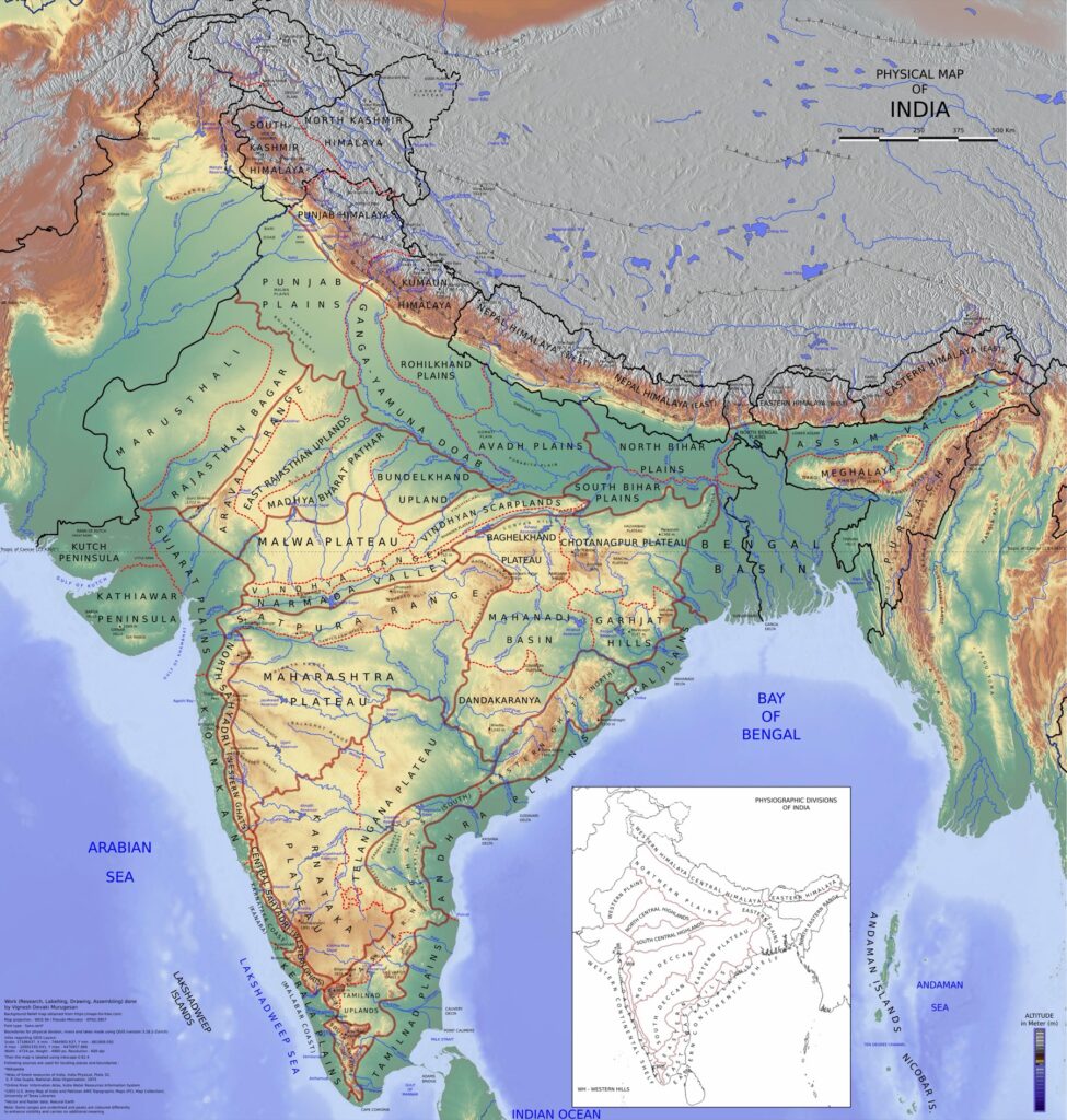
The Coastal Plains of India are the narrow strips of low-lying land that fringe the peninsular plateau along the Arabian Sea in the west and the Bay of Bengal in the east. They run for about 7,517 kilometres including island coastlines, with the mainland coastal plain stretching roughly 6,100 kilometres from the Rann of Kutch in Gujarat to the Sundarbans in West Bengal. The Coastal Plains of India are divided into two distinct systems: the Western Coastal Plain along the Arabian Sea, and the Eastern Coastal Plain along the Bay of Bengal. They differ sharply in width, geomorphology, river behaviour, port capacity, and economic profile.
For UPSC, the Coastal Plains of India are tested through prelims facts (sub-divisions, lagoons, ports, deltas), mains questions (comparison of east and west coast, blue economy, climate change impact, port-led development), and current-affairs angles (Sagarmala, Bharatmala, port modernisation). This article works through both coasts section by section.
Quick Facts About the Coastal Plains of India
- Total length of mainland coast: about 6,100 kilometres
- Total Indian coastline including islands: 7,517 kilometres
- Number of coastal states: 9 (Gujarat, Maharashtra, Goa, Karnataka, Kerala, Tamil Nadu, Andhra Pradesh, Odisha, West Bengal)
- Number of coastal Union Territories: 4 (Daman and Diu, Puducherry, Andaman and Nicobar, Lakshadweep)
- Western coast width: 10 to 80 kilometres
- Eastern coast width: 100 to 130 kilometres
- Major ports: 13 (operated by central government)
Western Coastal Plain
The Western Coastal Plain runs from the Rann of Kutch in Gujarat to Cape Comorin (Kanyakumari) in Tamil Nadu, along the Arabian Sea, between the Western Ghats and the sea. It is comparatively narrow, ranging from 10 to 80 kilometres in width, with a generally straight and rocky coastline. The plain is submerged in origin in most places, which means rivers do not form true deltas here but rather drown valleys called estuaries.
Sub-divisions of the Western Coastal Plain
The Western Coastal Plain is conventionally divided into four sub-sections:
1. Kachchh and Kathiawar Coast
This is the northernmost part, covering Gujarat. It is the widest section of the western coast. It includes the Rann of Kutch (a salt marsh that floods seasonally), the Kathiawar peninsula, and the Gulf of Khambhat (Cambay). Important features here include the Diu island, the port of Kandla (Deendayal Port), and the Alang ship-breaking yard.
2. Konkan Coast
The Konkan stretches from Daman to Goa, covering Maharashtra and northern Konkan. It is narrow, rocky, and indented with creeks and estuaries. Major rivers like the Narmada and Tapi form estuaries (not deltas) where they meet the Arabian Sea. The Konkan hosts Jawaharlal Nehru Port Trust (JNPT, now Jawaharlal Nehru Port Authority) near Mumbai, which is India’s largest container port, along with Mumbai Port and Mormugao (Goa).
3. Karnataka Coast (Kanara Coast)
From Goa to Mangaluru, this section is also called the Kanara Coast. The Sahyadris drop sharply to the sea, creating spectacular cliffs and small pocket beaches. The Sharavathi River forms the Jog Falls before reaching the coast. Major ports include New Mangalore Port and Karwar.
4. Malabar Coast
The Malabar Coast extends from Mangaluru to Kanyakumari, covering Kerala and the southern tip of Tamil Nadu. It is the narrowest and most distinctive section of the western coast, marked by a continuous chain of brackish water lagoons called kayals or backwaters. The Vembanad and Ashtamudi lagoons are the largest. The Kochi (Cochin) Port lies on Vembanad. Vizhinjam, India’s first dedicated container transshipment port, is on the southern Malabar coast.
Major Features of the Western Coast
- Estuaries instead of deltas due to faulting and submergence (Narmada, Tapi)
- Backwaters (kayals) along the Malabar coast
- Several offshore islands including Diu, Elephanta, Vypin
- Heavy southwest monsoon rainfall, especially over Konkan and Malabar
- Tropical evergreen and semi-evergreen forests on the Ghats slopes
- High population density on Malabar (Kerala)
Eastern Coastal Plain
The Eastern Coastal Plain runs from the Ganga delta in West Bengal to Kanyakumari in Tamil Nadu, along the Bay of Bengal, between the Eastern Ghats and the sea. It is wider, more continuous, and emerged in origin, which means it slopes gently and allows rivers to build large deltas. Its width ranges from 100 to 130 kilometres.
Sub-divisions of the Eastern Coastal Plain
The Eastern Coastal Plain is conventionally divided into three sub-sections:
1. Utkal Coast
The Utkal Coast covers the Odisha coastline. It includes the Mahanadi delta and Chilika Lake, India’s largest brackish water lagoon (about 1,165 square kilometres, listed as a Ramsar site). Paradip is the major port here. The Bhitarkanika mangroves, the second largest mangrove forest in India after the Sundarbans, lie on this coast. Olive Ridley turtle mass nesting at Gahirmatha is a globally significant ecological event.
2. Northern Circars
The Northern Circars cover the coast of Andhra Pradesh from the Odisha border to the Krishna delta. It includes the Godavari delta (the second largest delta in India after the Ganga) and the Krishna delta. Major ports: Visakhapatnam (India’s third-largest port by tonnage and home to the Eastern Naval Command) and Krishnapatnam.
3. Coromandel Coast
The Coromandel Coast covers the Tamil Nadu coastline. It includes the Cauvery delta in the Thanjavur region (the “rice bowl of South India”), Pulicat Lake (a brackish lagoon shared with Andhra Pradesh, home to the Pulicat Bird Sanctuary), and the Palk Strait separating India from Sri Lanka. Chennai Port and Ennore Port are the major commercial ports. Tuticorin (V.O. Chidambaranar Port) on the southern Coromandel is a major bulk port.
Major Features of the Eastern Coast
- Large deltas of the Mahanadi, Godavari, Krishna, Cauvery, and the Ganga-Brahmaputra system
- Lagoons: Chilika (Odisha) and Pulicat (Andhra-Tamil Nadu border)
- Wide, gently sloping continental shelf
- Subject to severe tropical cyclones from the Bay of Bengal
- Lower average rainfall than west coast, but very heavy rainfall during the northeast monsoon on Tamil Nadu coast
- Major fishing and aquaculture zone (Andhra Pradesh leads India in shrimp exports)
Western Coast vs Eastern Coast: Comparison
UPSC frequently tests the contrast between the two coasts.
| Feature | Western Coastal Plain | Eastern Coastal Plain |
|---|---|---|
| Origin | Submerged | Emerged |
| Length | About 1,500 km mainland | About 1,100 km mainland (but wider) |
| Width | 10 to 80 km | 100 to 130 km |
| River mouths | Estuaries (Narmada, Tapi) | Deltas (Mahanadi, Godavari, Krishna, Cauvery) |
| Coastline | Indented, rocky, narrow | Smooth, sandy, wide |
| Lagoons | Kayals/backwaters (Malabar) | Chilika, Pulicat |
| Major ports | Mumbai, JNPT, Kandla, Mormugao, Mangaluru, Kochi | Kolkata, Paradip, Visakhapatnam, Chennai, Tuticorin |
| Rainfall | Heavy SW monsoon | Heavy NE monsoon on Tamil Nadu coast |
| Cyclones | Few | Frequent and severe |
| Soils | Lateritic, sandy in places | Alluvial in deltas, sandy elsewhere |
| Economic profile | Trade, refineries, transshipment | Agriculture, fisheries, heavy industry |
Deltas of the Indian Coastal Plains
The deltas of the Coastal Plains of India are concentrated on the eastern coast because of the gentle slope and the eastward flow of the peninsular rivers.
- Ganga-Brahmaputra delta (West Bengal and Bangladesh): the world’s largest delta, includes the Sundarbans, the world’s largest mangrove forest
- Mahanadi delta (Odisha)
- Godavari delta (Andhra Pradesh): the second largest delta in India
- Krishna delta (Andhra Pradesh)
- Cauvery delta (Tamil Nadu): the rice bowl of South India
On the west coast, the Narmada and Tapi form estuaries rather than deltas because their lower courses run through faulted rift valleys with subsiding floors.
Lagoons and Backwaters
The Coastal Plains of India host several major lagoons that are ecologically and economically significant.
- Chilika Lake (Odisha): India’s largest brackish water lagoon, about 1,165 sq km, Ramsar site, important wintering ground for migratory birds, only home of the Irrawaddy dolphin in India
- Pulicat Lake (Andhra-Tamil Nadu border): India’s second largest brackish lagoon, Pulicat Bird Sanctuary
- Vembanad Lake (Kerala): India’s longest lake, about 96 km, Ramsar site, hosts the annual Nehru Trophy snake boat race
- Ashtamudi Lake (Kerala): another major backwater, Ramsar site
Major Ports of the Coastal Plains
India has 13 major ports operated by the central government and over 200 non-major ports.
Major ports on the western coast:
- Deendayal (Kandla) — Gujarat
- Mumbai — Maharashtra
- Jawaharlal Nehru (JNPA) — Maharashtra (India’s largest container port)
- Mormugao — Goa
- New Mangalore — Karnataka
- Cochin — Kerala
- Vizhinjam (newer, transshipment focus) — Kerala
Major ports on the eastern coast:
- Kolkata (Syama Prasad Mookerjee) — West Bengal
- Paradip — Odisha
- Visakhapatnam — Andhra Pradesh
- Chennai — Tamil Nadu
- Ennore (Kamarajar) — Tamil Nadu
- V.O. Chidambaranar (Tuticorin) — Tamil Nadu
Climate of the Coastal Plains
The two coasts have markedly different rainfall regimes.
The Western Coast receives very heavy rainfall from the southwest monsoon between June and September. The Western Ghats force the monsoon winds to rise sharply, producing some of the highest rainfall totals in India (Mahabaleshwar, Agumbe). Annual rainfall on Konkan and Malabar commonly exceeds 2,500 millimetres.
The Eastern Coast receives moderate rainfall in the southwest monsoon, but the Tamil Nadu coast receives the bulk of its rainfall during the northeast monsoon (October to December). The Bay of Bengal cyclones contribute heavy episodic rainfall and storm surges. Annual rainfall on most of the Coromandel is 1,000 to 1,200 millimetres, with regional variation.
Soils and Agriculture
The eastern deltaic soils are extremely fertile alluvial soils, supporting intensive paddy cultivation. The Krishna-Godavari and Cauvery deltas are among the most productive rice regions in India. The Mahanadi delta produces rice, jute, and sugarcane.
The western coast has lateritic and red soils on the narrow plain, with patches of alluvium near river mouths. Konkan is known for cashew, mango (Alphonso), coconut, and rice. Kerala specialises in coconut, rubber, spices (pepper, cardamom, ginger), and tea on the Ghats slopes.
Strategic and Economic Importance
The Coastal Plains of India are central to the country’s economy and security.
- Trade: about 95 percent of India’s foreign trade by volume and 70 percent by value moves through the ports of the coastal plain
- Refineries and petrochemicals: Jamnagar (Gujarat) hosts the world’s largest single-location refinery complex; Mangaluru, Mumbai, Vizag, and Paradip are major refining centres
- Fisheries: India is the third-largest fish producer in the world, with significant marine catch from both coasts
- Defence: Eastern Naval Command at Visakhapatnam, Western Naval Command at Mumbai, Southern Naval Command at Kochi
- Tourism: Goa, Kerala backwaters, Konkan beaches, Andaman islands
- Inland Waterway 3 (West Coast Canal in Kerala) operates on the Malabar backwaters
Climate Change and the Coastal Plains
The Coastal Plains of India are highly exposed to climate change. Sea level rise threatens low-lying delta zones, particularly the Sundarbans, the Godavari-Krishna delta, and the Mahanadi delta. The IPCC’s AR6 projects roughly 0.3 to 0.6 metres of sea level rise by 2100 for the north Indian Ocean. Increased cyclone intensity in the Bay of Bengal, observed since the 2000s, adds to the risk on the eastern coast. Coastal erosion is now a significant problem on parts of the Kerala and Odisha coasts.
Coastal Plains in the UPSC Syllabus
The Coastal Plains of India appear in GS-1 Geography under the physical features of India and natural vegetation, in GS-3 Environment under coastal ecosystems, in GS-3 Economy under ports and infrastructure, and in current affairs under Sagarmala, Bharatmala, Vizhinjam, and the Blue Economy. Prelims focuses on:
- Width and length of each coast
- Sub-divisions and their states
- Lagoons and their classification (brackish vs freshwater)
- Major ports and their states
- Differences between west and east coast (estuary vs delta)
Mains Practice Questions
- Compare and contrast the western and eastern coastal plains of India with reference to their geomorphic features, river mouths, and economic profile. (15 marks)
- Discuss the strategic and economic significance of the eastern coastal plain in the context of India’s Act East Policy. (15 marks)
- Examine the impact of climate change on the coastal plains of India and suggest adaptation measures. (15 marks)
- Assess the role of the Sagarmala programme in transforming the Coastal Plains of India into engines of economic growth. (10 marks)
Why the Coastal Plains of India Matter
The Coastal Plains of India are where the country interfaces with the world. They host the ports through which India trades, the deltas that feed the country, the mangroves that buffer storms, the lagoons that sustain fisheries, and the naval bases that secure the Indian Ocean. They also concentrate climate risk: half of India’s population in coastal districts faces direct exposure to sea level rise and tropical cyclones. For UPSC, mastery of the Coastal Plains of India means being able to distinguish Konkan from Malabar from Coromandel, knowing which rivers form deltas and which form estuaries, and being able to argue clearly about how a long coastline shapes India’s economy and security.
Frequently Asked Questions
What are the Coastal Plains of India?
The Coastal Plains of India are the narrow strips of low-lying land that fringe the peninsular plateau along the Arabian Sea and the Bay of Bengal. They are divided into the Western Coastal Plain and the Eastern Coastal Plain.
How long is the coastline of India?
India’s total coastline is 7,517 kilometres including the island coastlines of the Andaman and Nicobar Islands and Lakshadweep. The mainland coastline is about 6,100 kilometres.
What is the difference between the eastern and western coastal plains?
The Western Coastal Plain is narrow (10 to 80 km), submerged in origin, with estuaries instead of deltas, and a rocky indented coastline. The Eastern Coastal Plain is wider (100 to 130 km), emerged in origin, with large deltas, and a smoother sandy coastline.
What are the sub-divisions of the Western Coastal Plain?
The Western Coastal Plain has four sub-divisions: the Kachchh and Kathiawar coast in Gujarat, the Konkan coast in Maharashtra, the Karnataka (Kanara) coast in Karnataka, and the Malabar coast in Kerala.
What are the sub-divisions of the Eastern Coastal Plain?
The Eastern Coastal Plain has three sub-divisions: the Utkal coast in Odisha, the Northern Circars in Andhra Pradesh, and the Coromandel coast in Tamil Nadu.
Which is the largest lagoon of India?
Chilika Lake on the Odisha coast is the largest brackish water lagoon in India, with an area of about 1,165 square kilometres. It is a Ramsar site and an important wintering ground for migratory birds.
Why does the Narmada form an estuary instead of a delta?
The Narmada flows through a faulted rift valley between the Vindhya and Satpura ranges. The lower course continues into a subsiding section of the western coast, so the river drops its sediment in a drowned river mouth rather than building a fan-shaped delta. The same applies to the Tapi.
Which is the largest port of India?
The Jawaharlal Nehru Port (JNPA) near Mumbai is India’s largest container port. Deendayal Port (Kandla) in Gujarat handles the largest cargo tonnage among the major ports.
Tell Google you want more of this.
Add Anantam IAS as a preferred sourceOne tap, and this site shows up more often in your own Top Stories, AI Overviews and AI Mode. Remove it any time.






