ज़्यादातर अभ्यर्थियों से Harappan site का नाम पूछिए, तो Harappa, Mohenjo-daro और शायद Lothal सुनाई देंगे। Dholavira छूट जाता है और यह गलती है, क्योंकि यही वह site है जो एक ऐसा सवाल हल करती है जिसका जवाब बाकी sites नहीं देतीं: Bronze Age city लगभग बिना बारिश वाले desert में 1,000 साल से अधिक कैसे जीवित रही? इसका जवाब इतना advanced water engineering है कि Dholavira India की 40th UNESCO World Heritage Site बनी और देश में Indus Valley Civilization की list में आने वाली पहली city रही।
Dholavira को अलग बनाने वाली कोई एक spectacular find नहीं, बल्कि पूरी design philosophy है। यह brick के बजाय stone से बनी city थी, तीन walled districts में बँटी थी और reservoirs के network से घिरी थी। इससे seasonal runoff के कुछ दिनों का water साल भर की supply में बदल जाता था। यह picture ठीक बैठ जाए, तो Dholavira ancient history, art and culture और water conservation या urban planning के सवालों के लिए सबसे useful case studies में से एक बन जाती है।
Dholavira कहाँ है और location ही पूरी story क्यों है
Dholavira Gujarat के Great Rann of Kutch में ऊँची जमीन वाले island Khadir bet पर है। Setting city के बारे में लगभग सब कुछ समझा देती है। “Bet” का मतलब island है। Khadir आसपास के salt flats से थोड़ा ऊँचा है, इसलिए Rann flood हो तो भी dry रहता है। साल के ज़्यादातर समय इसके चारों ओर salt और cracked mud का चमकता सफेद विस्तार रहता है, जहाँ कुछ नहीं उगता और surface पर fresh water नहीं बहता।
Harappans ने यही puzzle solve की थी। Site पर दो seasonal streams, Manhar और Mansar, थीं जो monsoon में थोड़े समय के लिए बहती थीं। Rainfall इतनी कम थी कि modern farmer इसे unfarmable कहता। फिर भी करीब 100 hectares की city इस island पर centuries तक फलती-फूलती रही। Location harshness के बावजूद नहीं चुनी गई थी। Defensible island और coast तथा Rann के trade routes के पास होने की strategic value के लिए चुनी गई थी। Water problem को engineering से solve कर दिया गया।
पास के modern village का नाम Dholavira है, इसलिए site भी इसी नाम से जानी जाती है। Archaeologists इसे Kotada या Kotada Timba भी कहते हैं, जिसका अर्थ “large fort” है। यह नाम उस mound से आया जिसने पहली बार buried city का संकेत दिया था। 1967-68 में Archaeological Survey of India के J. P. Joshi ने इसे formally discover किया। Serious excavation 1990 में archaeologist Ravindra Singh Bisht के under शुरू हुई। उनकी team ने एक दशक से ज़्यादा समय में city को uncover किया। Dholavira mature Harappan cities में सबसे बड़ी sites में है और उसी Indus Valley Civilization का हिस्सा है जिसके broad features आपको किसी एक site पर जाने से पहले मालूम होने चाहिए।
Dholavira की पहचान बना देने वाला water-conservation system
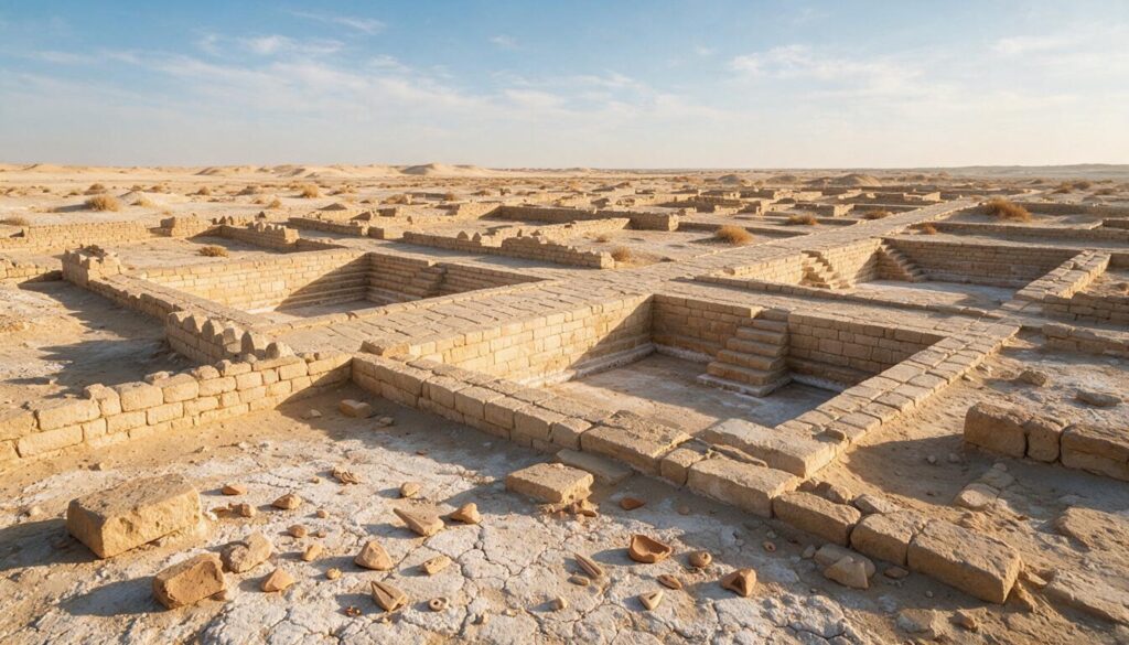
Dholavira के reservoirs ने इसे world map पर जगह दी और site का सबसे exam-relevant fact भी यही है। दो छोटी seasonal streams और बेहद कम बारिश वाली जगह पर Harappans ने कम-से-कम sixteen reservoirs बनाए। इन्हें rock में काटकर city की walls के भीतर ring की तरह रखा गया और monsoon की हर बूंद store की गई।
Scale को hard number की तरह याद रखिए। कुछ stone-cut reservoirs करीब 7 metres deep और लगभग 79 metres long तक हैं। Together वे walled city के बड़े हिस्से में फैले थे। इसलिए Dholavira को कभी-कभी ऐसी settlement कहा जाता है जो water के चारों ओर बनी थी, न कि water houses के चारों ओर। पूरी city को houses के ऊपर बना giant rainwater tank सोचिए। बात बहुत दूर की नहीं है।
System chain की तरह काम करता था। Chain समझेंगे, तो fact answer बन जाएगा। Seasonal Manhar और Mansar streams के across earthen और stone dams तथा bunds बनाए गए ताकि थोड़े समय के flow को रोका जा सके। Water को stone drains के जरिए reservoirs में लाया जाता और लंबे dry months तक store किया जाता। Rock-cut wells, जिनमें citadel के पास का एक बड़ा stepped well सबसे पुराने known wells में है, backup के रूप में groundwater तक पहुँचते थे। City के भीतर storm water और rooftops का runoff भी harvest करके tanks तक पहुँचाया जाता था। कोई water salt में बहकर गायब नहीं होने दिया जाता था।
Engineering केवल storage तक सीमित नहीं थी। Excavators को rock-cut channels और inlets मिले जो reservoirs के बीच water ले जाते थे। इसलिए tanks isolated pits नहीं, connected system की तरह काम करते थे। Eastern side का एक बड़ा reservoir पूरी depth तक उतरती steps के साथ बनाया गया था, ताकि dry season में level गिरने पर लोग water तक पहुँच सकें। इतने scale पर water move, store और ration करने वाली city improvisation नहीं कर रही थी। यह 4,000 years पहले planned water utility चला रही थी, उस समय जब यह phrase भी मौजूद नहीं था। यही बात Dholavira को इस argument का anchor बनाती है कि Harappans lucky river settlers नहीं, serious hydraulic engineers थे।
इसीलिए rainwater harvesting और traditional water management के सवाल में Dholavira go-to example है। यह दिखाती है कि India में sophisticated water conservation modern borrowing नहीं, 4,000 साल पुरानी indigenous practice है। City planning के स्तर पर civilization को scarce resource के storage के around organise किया जा सकता है। Ancient India में genuine engineering science का argument लिखें, तो यह reservoir network science and technology in ancient India के achievements के पास होना चाहिए।
Three parts वाली city: citadel, middle town और lower town
Dholavira strict geometric plan पर बनी थी। इसका clearest signature यह है कि city three distinct walled sections में divided थी। यह layout बाकी कई Harappan cities से अधिक rigidly separated था। इन three sections को fix कर लेंगे, तो city की structure fix हो जाएगी।
Hierarchy में सबसे ऊपर citadel था, सबसे heavily fortified zone। इसे excavators ने दो adjoining enclosures में बाँटा, जिन्हें castle और bailey कहा। Castle की double ramparts असाधारण रूप से thick थीं। लगभग निश्चित रूप से rulers या administrators यहीं रहते थे। यह city का highest और best-defended ground था। इसके नीचे और बगल में middle town था, अपने fortification, streets और separate gateway वाला planned residential area। यहाँ officials और better-off residents रहते होंगे। सबसे बाहर lower town था, जो सबसे बड़ा area था। General population और craft workers यहीं रहते और काम करते थे; इसके कुछ हिस्से भी enclosed थे।
| Division | क्या था | संभवतः कौन रहता था |
|---|---|---|
| Citadel (castle + bailey) | Double ramparts वाला highest और most fortified zone | Rulers और administrators |
| Middle town | अलग से walled planned residential area | Officials और well-off residents |
| Lower town | सबसे बड़ा, partly walled area | General population और craftspeople |
यह tripartite plan analytical weight रखता है। यह clearly stratified society और recognised hierarchy of space की ओर इशारा करता है। Harappan world के social organisation पर debate में इसे evidence की तरह इस्तेमाल कर सकते हैं। यह deliberate town planning का level भी दिखाता है, जहाँ water bodies और defensive walls residential zoning के साथ integrated थे। यही Dholavira को wider Harappan civilization और urban order की reputation में firmly रखता है।
एक और feature के लिए एक line रखें। Castle और middle town के बीच एक बड़ा open ground था, जिसे excavators ceremonial या stadium-like space मानते हैं। यह public gatherings या festivals के लिए इस्तेमाल होता होगा। यही detail Mains answer को generic होने से बचाती है।
Stone city और ten-sign signboard
Dholavira को Harappan sites के बीच genuinely distinctive बनाने वाली दो बातें हैं। दोनों memorable answer points हैं।
पहली इसकी building material है। Harappa और Mohenjo-daro में buildings overwhelmingly baked और mud brick की हैं। Dholavira में बची हुई लगभग हर चीज़ locally quarried और properly laid dressed stone से बनी है। यह बदलाव partly practical था। Khadir island पर अच्छा stone मौजूद था और bricks के लिए clay नहीं। इससे Dholavira अपने river-valley cousins से अलग look और durability पाती है। Harappan sites compare करने हों, तो “brick cities versus Dholavira, the stone city” एक clean high-value distinction है।
दूसरी है famous Dholavira signboard। Citadel के northern gateway के पास एक chamber में excavators को Indus script के ten large signs वाली long inscription के remains मिले। हर sign करीब 37 centimetres high था। यह gypsum में लगभग 3 metres long wooden board पर inlaid था। Wood सड़ गया, लेकिन gypsum letters का arrangement बचा रहा। यह अब तक मिली longest single Indus inscriptions में से एक है। Gateway के ऊपर mounted था, इसलिए city में आने वाला हर व्यक्ति उसे देखता। इसी वजह से कुछ scholars इसे world’s oldest known signboard कहते हैं।
ईमानदार catch यह है कि कोई इसे पढ़ नहीं सकता। Indus script अभी undeciphered है। इसलिए नहीं पता कि signboard city का नाम बताती थी, visitors को bless करती थी, warning देती थी या कुछ और। इसका महत्व meaning में नहीं, context और scale में है। यह direct evidence है कि Harappans public और monumental writing इस्तेमाल करते थे। Early Indian writing और उसकी limits पर wider debate के लिए inscriptions in ancient India का survey पढ़िए।
Trade, crafts और खाली graves का रहस्य
Dholavira self-contained farming town नहीं थी। Coast और Rann के पास location ने इसे trading hub बनाया और finds भी यही दिखाते हैं। Excavators को busy craft economy मिली: carnelian और agate जैसे semi-precious stones से bead-making workshops, nearby Arabian Sea से shell-working, copper objects, seals, weights, terracotta और pottery। यहाँ मिले standardized weights और Indus seals पूरे Harappan world में इस्तेमाल होने वाले उसी system का हिस्सा हैं। इसका मतलब Dholavira shared network में जुड़ी थी, अपनी ही दुनिया में बंद नहीं।
यह network India से बहुत आगे तक पहुँचा था। Dholavira उस maritime route पर थी जो Harappans को Mesopotamia से जोड़ता था। Trade उस region के जरिए होता था जिसे Mesopotamian records Meluhha कहते हैं। Beads, timber, ivory और semi-precious stones के बदले west के metals और goods आते थे। Salt island पर बसी यह छोटी city earth के oldest long-distance trade systems में से एक का node थी। Harappan commerce या ancient sea links पर answer में यह point रखें।
सबसे odd finds city के west में मौजूद funerary ground में हैं। Dholavira cemetery में बड़े और dome-shaped memorial structures की एक striking group है। Excavation में इनमें कोई skeleton या body नहीं मिली। इन्हें cenotaphs समझना सबसे ठीक है, यानी actual graves नहीं, किसी की memory में बनाए गए empty memorials। इससे death और commemoration के बारे में distinctive belief का संकेत मिलता है। Students के लिए यह memorable और थोड़ा eerie detail है: Harappan लोग grand tombs बनाते थे और फिर उन्हें जानबूझकर खाली छोड़ते थे।
Dholavira कितने समय तक रही और decline कैसे हुआ
Dholavira short-lived outpost नहीं थी। यह well over 1,000 years तक continuously occupied रही। इसके excavator R. S. Bisht ने site पर seven cultural stages पहचानीं, जो लगभग 2650 BCE से 1450 BCE तक फैली थीं। एक ही mound में Harappan city का rise, peak और gradual decline पढ़ पाना इसे valuable बनाता है।
Stages familiar arc दिखाती हैं। Early phases में settlement fortified town बनती है। Middle phases में citadel और reservoirs के साथ mature planned city peak पर दिखती है। Later phases decline record करती हैं। 1900 से 1850 BCE के आसपास near-desertion का period भी आया। इसके बाद Late Harappan phase में site poorer और less-organised scale पर फिर बसाई गई। Grand town planning की जगह छोटी rounder houses और simpler life ने ले ली।
Decline शायद एक single catastrophe के बजाय slow squeeze था: drying climate और weakening monsoon, seasonal streams का कम होना, Rann में changes जिससे trade और coastline प्रभावित हुए और पूरे region में Harappan urban life का wider eclipse। Monsoon कमजोर पड़ा, तो sixteen reservoirs भी permanent shortfall को रोक नहीं सके। Trade भी thin हुई क्योंकि wider Harappan world unravel हो रहा था। जिस location ने clever water engineering से Dholavira को thrive कराया, water के unreliable होते ही वही exposure बन गई। Harappan decline पर answer में यह neat और quotable irony है।
Dholavira UNESCO World Heritage Site क्यों बनी
July 2021 में Dholavira को UNESCO World Heritage List में inscribe किया गया। यह India की 40th World Heritage Site और India में Indus Valley Civilization की पहली site बनी। यह list में Gujarat की fourth site भी थी। चार facts ठीक-ठीक याद रखें: overall 40th, first IVC site, 2021 और Gujarat से।
UNESCO ने Dholavira के outstanding water-management system, unique multi-layered fortifications और stone architecture, planned three-part urban form, funerary structures तथा long-distance trade के evidence को recognise किया। Nomination ने यह case रखा कि site Harappan urban idea को unusually complete और legible form में बचाती है और later reuse ने इसे destroy नहीं किया। Country की inscribed sites revise करते समय UNESCO World Heritage Sites in India की full list को World Heritage Day और UNESCO criteria के साथ रखें।
Exam के लिए Dholavira को कैसे पढ़ें
Dholavira high-value इसलिए है क्योंकि यह syllabus के कई areas से एक साथ जुड़ती है। इसे connector की तरह सीखिए।
पहले five hard facts anchor करें: Gujarat के Great Rann of Kutch में Khadir bet पर location; 1990 से R. S. Bisht की excavation; sixteen-plus stone reservoirs; ten-sign gypsum signboard; और 2021 में India की 40th तथा first-IVC UNESCO site बनना। फिर three-part plan, यानी castle और bailey वाला citadel, middle town और lower town, को structural spine बनाइए। दो contrasts ready रखें: brick cities versus stone city और river-valley sites versus desert-island water city। इन्हीं contrasts से Harappa, Mohenjo-daro और Lothal के साथ Dholavira को एक sentence में compare कर पाएँगे।
Mains में Dholavira को standalone topic नहीं, evidence की तरह deploy करें। यह ancient Indian water conservation, Harappan town planning की sophistication, social stratification और climate change के सामने civilizations की vulnerability, इन सबके answers support करती है। Site facts के लिए Archaeological Survey of India और UNESCO पर lean करें। Framing के लिए standard NCERT और art-and-culture material रखें। हर reservoir का dimension रटने की जरूरत नहीं। Concept, location और five anchor facts marks के लिए काफी हैं।
सामान्य प्रश्न
Dholavira कहाँ located है?
Dholavira Gujarat के Kutch district में Great Rann of Kutch की ऊँची जमीन वाले island Khadir bet पर है। यह Rann के salt flats के बीच है और water के लिए Manhar तथा Mansar की दो seasonal streams पर depend करती थी।
Dholavira famous क्यों है?
अपने extraordinary water-conservation system के लिए। लगभग rainless desert में Harappans ने कम-से-कम sixteen stone reservoirs और dams, drains तथा wells का network बनाया। Dholavira stone से बनी city, three-part city plan और ten-sign signboard के लिए भी famous है।
Dholavira signboard क्या है?
यह ten large Indus-script signs वाली long inscription है। हर sign करीब 37 centimetres high था। इसे लगभग 3 metres long wooden board पर gypsum में inlay किया गया था और northern gateway के ऊपर लगाया गया था। यह longest known Indus inscriptions में है, लेकिन Indus script undeciphered होने से इसका meaning unknown है।
Dholavira की city कैसे divided थी?
तीन walled sections में: citadel, जिसमें heavily fortified castle और adjoining bailey थे; middle town; और सबसे बड़ा lower town। यह साफ़ tripartite division stratified और well-planned society की ओर इशारा करती है।
Dholavira को किसने discover और excavate किया?
इसे 1967-68 में Archaeological Survey of India के J. P. Joshi ने discover किया। Large-scale excavation 1990 में archaeologist R. S. Bisht के under शुरू हुई। उन्होंने site पर seven cultural stages पहचानीं।
Dholavira UNESCO World Heritage Site कब बनी?
July 2021 में। यह India की 40th World Heritage Site और India में Indus Valley Civilization की recognition पाने वाली पहली site बनी। यह Gujarat की fourth UNESCO site थी।
Dholavira कितनी पुरानी है और decline क्यों हुआ?
यह लगभग 2650 BCE से 1450 BCE तक seven stages में 1,000 years से अधिक समय तक occupied रही। Decline को drying climate, weakening monsoon, seasonal streams के सिकुड़ने, Rann में changes और Harappan urban life के wider eclipse से जोड़ा जाता है।
अभ्यास प्रश्न
1. Dholavira निम्नलिखित में से कहाँ located है?
a) Gujarat का Kathiawar peninsula
b) Great Rann of Kutch, Gujarat में Khadir bet
c) Haryana के Ghaggar plains
d) Sindh की lower Indus valley
उत्तर: b) Great Rann of Kutch, Gujarat में Khadir bet
2. Dholavira signboard important क्यों है?
a) इसे पूरी तरह decipher करके city का नाम पढ़ लिया गया है
b) यह longest Indus-script inscriptions में से एक है, हालांकि undeciphered है
c) यह early Brahmi script में लिखी है
d) इसमें दो Harappan cities की treaty दर्ज है
उत्तर: b) यह longest Indus-script inscriptions में से एक है, हालांकि undeciphered है
3. Harappa और Mohenjo-daro से Dholavira को सबसे अलग कौन-सी feature बनाती है?
a) Potter’s wheel का इस्तेमाल
b) Great Bath की मौजूदगी
c) Brick के बजाय largely dressed stone में construction
d) Mother goddess की worship
उत्तर: c) Brick के बजाय largely dressed stone में construction
4. Dholavira के बारे में निम्नलिखित पर विचार कीजिए:
- यह citadel, middle town और lower town में divided थी।
- Water storage के लिए यह कम-से-कम sixteen reservoirs पर depend करती थी।
- यह UNESCO द्वारा inscribe की गई India की पहली Indus Valley site थी।
कौन-से सही हैं?
a) केवल 1 और 2
b) केवल 2 और 3
c) केवल 1 और 3
d) 1, 2 और 3
उत्तर: d) 1, 2 और 3
5. Dholavira UNESCO World Heritage Site किस वर्ष बनी?
a) 2004
b) 2014
c) 2021
d) 2024
उत्तर: c) 2021
Mains-style questions
- “Dholavira peak Harappan hydraulic engineering को represent करती है।” इसके water-conservation system और harsh environment के साथ civilization के adaptation पर चर्चा कीजिए।
- Building material, town planning और setting के आधार पर Dholavira की तुलना river-valley Harappan cities Harappa और Mohenjo-daro से कीजिए।
- Dholavira के three-part plan और signboard से Harappan world के social organisation और writing के use के बारे में क्या पता चलता है?
- Ancient Indian water-harvesting traditions contemporary water management के लिए lessons देती हैं। Dholavira के संदर्भ में चर्चा कीजिए।
- Dholavira के decline के कारण बताइए और इसे Harappan urbanism के अंत पर wider debate में रखिए।
Dholavira footnote बनने से इनकार करती है, इसलिए इसकी study reward करती है। यह proof है कि Harappans केवल उन जगहों पर settle नहीं हुए जहाँ rivers life आसान बनाती थीं। वे salt-ringed island पर great city engineer कर सकते थे और stored rain से उसे 1,000 years तक जीवित रख सकते थे। Reservoirs, stone, three towns और silent signboard याद रखिए। Ancient-history syllabus में यह सबसे versatile examples में से एक है, जो urban planning, water security और climate के साथ civilizations के rise तथा fall, तीनों के answers में बराबर काम आती है।