Super Typhoon Ragasa formed in the warm waters of the Western Pacific in mid-September 2025, intensified rapidly over the Philippine Sea, and tracked west-northwest through the South China Sea before brushing the southern coast of China and dumping record rainfall on Hong Kong. The storm became one of the strongest typhoons of the 2025 season, briefly reaching Category 5 strength on the Saffir-Simpson scale, and prompted comparisons with the most destructive Pacific typhoons of the last two decades.
For a UPSC aspirant, Ragasa is more than a piece of weather. It is a case study in how the same atmospheric phenomenon — a tropical cyclone — gets different names in different ocean basins, how the IMD classifies cyclones in our part of the world, and how a single storm can stretch the disaster preparedness machinery of three or four countries at once. The questions that come up in prelims and mains rarely focus on the storm’s name; they focus on the science of formation, the classification scales, and the institutional response.
Quick Facts on Super Typhoon Ragasa
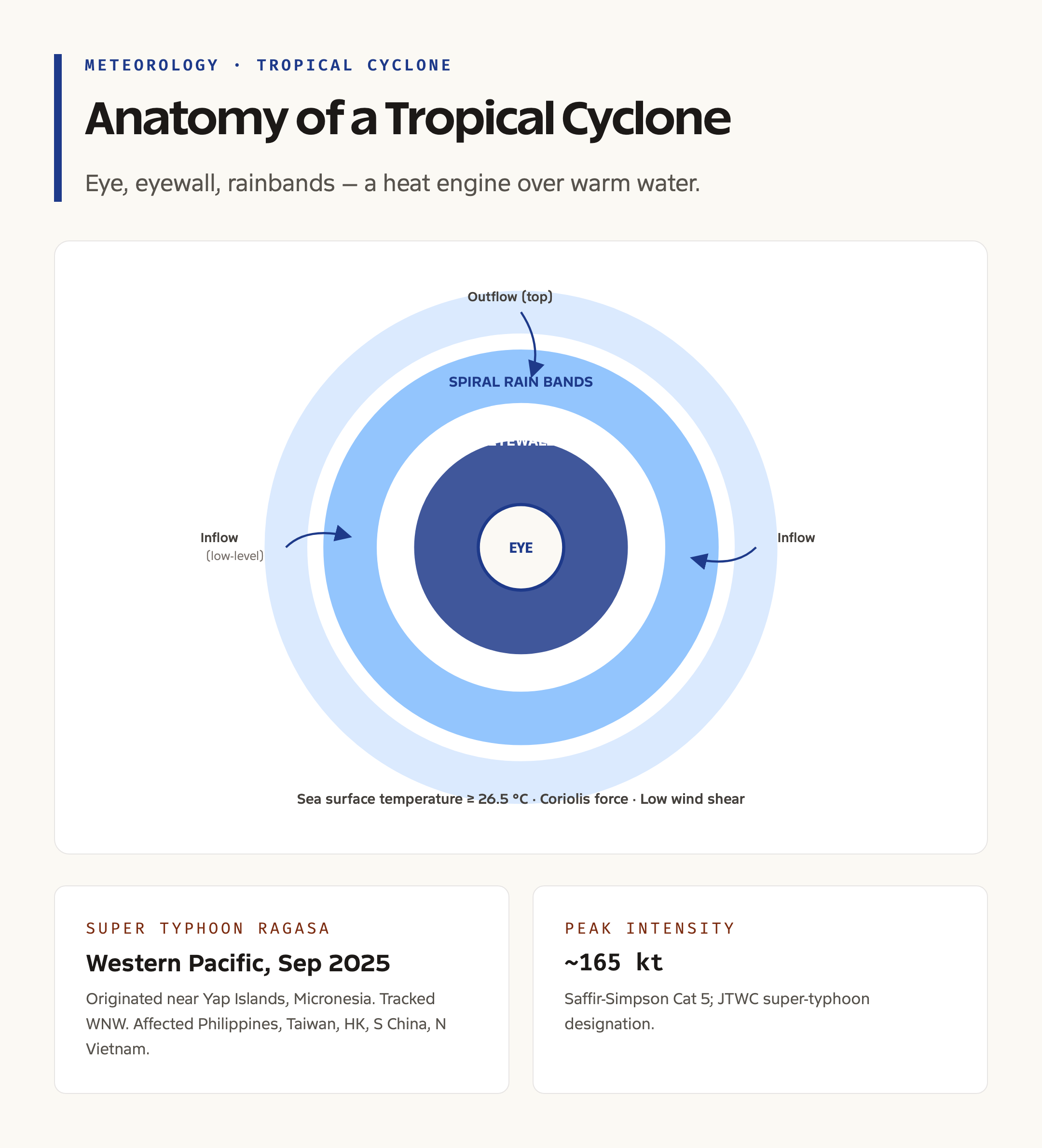
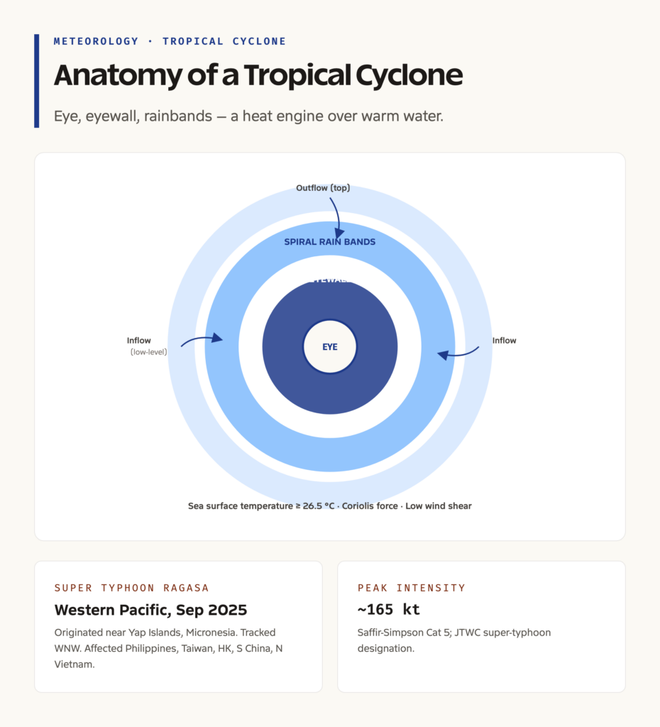
Ragasa originated near the Yap Islands in Micronesia and travelled west-northwest, affecting the Philippines, Taiwan, Hong Kong, southern China, and parts of northern Vietnam. At its peak it had sustained one-minute winds of about 165 knots, which corresponds to Category 5 on the Saffir-Simpson Hurricane Wind Scale. The Joint Typhoon Warning Center designated it a super typhoon, a category reserved for storms with one-minute sustained winds above 130 knots.
The name Ragasa was contributed by the Philippines to the World Meteorological Organization’s regional name list for the Western Pacific. The same phenomenon, had it formed in the Atlantic, would have been called a hurricane; in the Bay of Bengal it would have been called a cyclone; near Australia it would have been called a willy-willy. The name changes; the physics does not.
What a Tropical Cyclone Actually Is
A tropical cyclone is a deep low-pressure system over warm tropical oceans, organized around a small calm centre called the eye and surrounded by a ring of intense thunderstorms called the eyewall. Outside the eyewall, spiral rain bands feed moist air inward and upward. The system rotates counter-clockwise in the Northern Hemisphere and clockwise in the Southern Hemisphere because of the Coriolis effect produced by the Earth’s rotation.
A mature tropical cyclone is a heat engine. It draws energy from the latent heat released when water vapor evaporated from the warm ocean condenses inside the storm. The warmer the ocean, the more water vapor, the more energy, and the stronger the storm. This is why a one-degree rise in sea surface temperature can shift the upper limit of a storm’s intensity by several Saffir-Simpson categories.
Background and Historical Context
The classification of tropical cyclones into named categories began in the United States in the 1970s when civil engineer Herbert Saffir and meteorologist Robert Simpson developed a five-step wind-damage scale that has since become the international standard. The Indian Meteorological Department, which is responsible for cyclone forecasting in the North Indian Ocean basin, runs a parallel scale that begins with depression and deep depression and ends with super cyclonic storm.
The naming of cyclones in the North Indian Ocean basin began only in 2004, when eight countries — Bangladesh, India, the Maldives, Myanmar, Oman, Pakistan, Sri Lanka, and Thailand — agreed on a rotating list. The list was expanded in 2018 to include thirteen countries with the addition of Iran, Qatar, Saudi Arabia, the UAE, and Yemen. Each country contributes thirteen names, and the names are used in alphabetical order of contributing country.
Read this together with the broader topic of tropical and temperate cyclones and cyclones in India to anchor the geography of where these storms form and where they make landfall.
Conditions for Tropical Cyclone Formation
Five atmospheric and oceanic conditions must come together for a tropical cyclone to form. The first is a sea surface temperature of at least twenty-six and a half degrees Celsius, sustained to a depth of at least fifty metres. The second is the Coriolis force, which is zero at the Equator and increases poleward; this is why tropical cyclones do not form within five degrees of the Equator. The third is low vertical wind shear — strong winds aloft that change direction with height tear apart the developing vortex.
The fourth condition is a pre-existing area of disturbed weather, often a tropical wave or an old front, that provides the initial low-pressure seed. The fifth is upper-level divergence in the atmosphere, which evacuates air from the top of the storm and allows surface convergence at the bottom to continue feeding the system. When all five conditions are met, what begins as a cluster of thunderstorms can organize into a depression, then a tropical storm, and eventually a hurricane or typhoon.
Why Ragasa Mattered
Ragasa was not just a strong storm. It was a stress test for the disaster machinery of multiple jurisdictions. Hong Kong issued its highest typhoon warning, and authorities suspended public transport, closed schools and offices, and pre-positioned emergency teams in coastal districts. Mainland China evacuated hundreds of thousands of residents from coastal Guangdong. The Philippines, which the storm had grazed earlier in its track, activated its multi-agency response under the National Disaster Risk Reduction and Management Council.
The storm also reinforced a pattern that climate scientists have been documenting for years. Tropical cyclones are not necessarily becoming more frequent, but the proportion of high-intensity storms — Category 4 and 5 on the Saffir-Simpson scale — is rising as ocean temperatures climb. Rapid intensification, in which a storm gains thirty knots or more of wind speed in a twenty-four-hour period, is also becoming more common. Ragasa underwent two phases of rapid intensification before its peak, which made forecasting its landfall location and intensity unusually difficult.
Detailed Analysis of Cyclone Classification
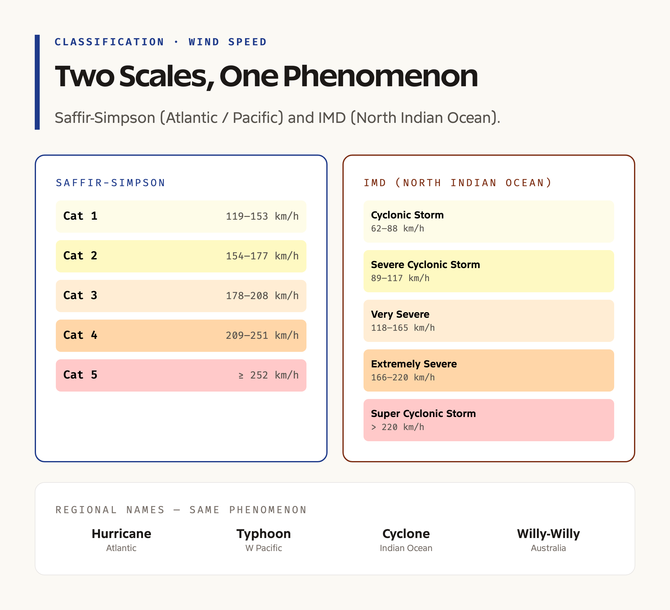
Cyclones in different ocean basins are classified using different scales, but the underlying physics is the same. The Saffir-Simpson scale, used in the Atlantic and Eastern Pacific, runs from Category 1 to Category 5 based on one-minute sustained wind speeds. The Joint Typhoon Warning Center adds a super typhoon designation above Category 5 wind speeds.
The IMD scale used in the North Indian Ocean is graded differently and is summarized below.
| IMD Category | Wind Speed (km/h) | Damage Capacity |
|---|---|---|
| Cyclonic Storm | 62 to 88 | Minor |
| Severe Cyclonic Storm | 89 to 117 | Moderate |
| Very Severe Cyclonic Storm | 118 to 165 | Major |
| Extremely Severe Cyclonic Storm | 166 to 220 | Severe |
| Super Cyclonic Storm | Above 220 | Catastrophic |
In addition to wind speed, the IMD also tracks the storm surge, which in many cases causes greater loss of life than the wind itself. The 1999 Odisha super cyclone produced a storm surge of nearly six metres along the Paradip coast and killed almost ten thousand people, mostly because of the inundation rather than the wind.
Comparative Look at Recent Cyclones in India
The North Indian Ocean basin produces about five to six named storms a year, of which two to three reach severe cyclonic storm strength. The 2024 and 2025 seasons produced a notable cluster.
| Cyclone | Basin | Landfall State | Year |
|---|---|---|---|
| Cyclone Dana | Bay of Bengal | Odisha–West Bengal coast | 2024 |
| Cyclone Asna | Arabian Sea | Gujarat (Saurashtra) | 2024 |
| Cyclone Fengal | Bay of Bengal | Tamil Nadu near Puducherry | 2024 |
| Cyclone Montha | Bay of Bengal | Andhra Pradesh coast | 2025 |
| Cyclone Shakti | Arabian Sea | Maharashtra coast | 2025 |
Two trends are worth noting. The first is the rising frequency of Arabian Sea cyclones, which historically were rare but have become more common as the Arabian Sea warms. The second is the higher proportion of post-monsoon cyclones in the Bay of Bengal, which traditionally is the more cyclone-prone basin. Read this together with disaster management for the institutional response.
Challenges in Cyclone Forecasting and Response
The first challenge is rapid intensification. A storm that strengthens by two Saffir-Simpson categories in twenty-four hours leaves coastal authorities with very little time to evacuate. The second is track forecasting near landfall. Even with modern numerical weather prediction, the cone of uncertainty around a forty-eight-hour landfall forecast can be a hundred kilometres wide, which translates into a real difference in which districts need to evacuate.
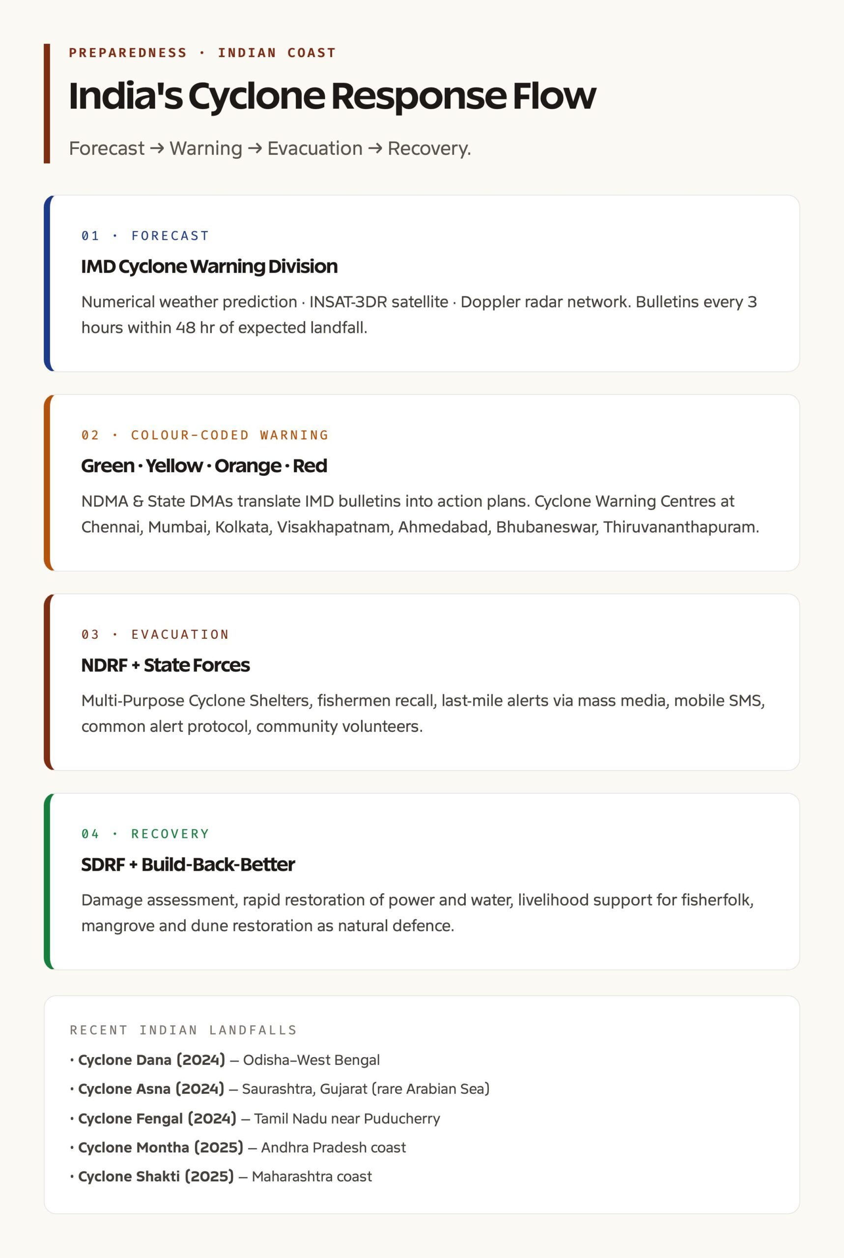
The third challenge is what disaster managers call the last mile. Once a warning is issued, getting it to fishermen at sea, coastal residents in informal settlements, and migrant workers in storm-prone districts requires a layered communication system that combines mass media, mobile alerts, community volunteers, and local language broadcasts. India’s Cyclone Warning Division runs one of the most evolved last-mile systems in the developing world, but gaps remain in the smaller islands and in remote coastal pockets.
A fourth challenge is climate-driven uncertainty in the historical baseline. Statistical return periods that worked in the twentieth century may no longer be valid as ocean temperatures shift. A hundred-year storm surge may now occur every fifty years, and infrastructure designed to the older standard becomes inadequate.
Prelims Pointers
Tropical cyclones in the Atlantic are called hurricanes, in the Western Pacific they are typhoons, in the Indian Ocean they are simply cyclones, and near Australia they are willy-willies. The minimum sea surface temperature for cyclogenesis is approximately twenty-six and a half degrees Celsius. Cyclones do not form within five degrees of the Equator because the Coriolis force is too weak.
Super Typhoon Ragasa formed in the Western Pacific in 2025, originated near the Yap Islands in Micronesia, and affected the Philippines, Taiwan, Hong Kong, southern China, and Vietnam. The Saffir-Simpson scale runs from Category 1 to Category 5. The IMD’s super cyclonic storm category begins at sustained wind speeds above 220 km/h. The 1999 Odisha cyclone is the only post-independence super cyclone to make landfall on the Indian mainland.
Mains Questions on Tropical Cyclones
Discuss the conditions necessary for the formation of a tropical cyclone and analyze the factors that influence its intensity. Compare the cyclone classification systems of the IMD and the Saffir-Simpson scale and evaluate India’s preparedness for high-intensity cyclonic events.
A complete answer would describe the heat-engine model of cyclones, the role of climate change in shifting the intensity distribution, the institutional architecture of cyclone warning in India through the IMD, the National Disaster Management Authority, and state disaster management authorities, and the importance of nature-based defences such as mangroves in absorbing storm surges. Reference to the mangrove ecosystem of India strengthens the answer.
Way Forward
A robust cyclone strategy needs four pillars. The first is forecasting capacity — investment in numerical weather prediction, dropsonde and aircraft reconnaissance for North Indian Ocean storms, and machine-learning models that exploit satellite data. The second is risk-informed coastal planning, which keeps high-occupancy infrastructure away from low-lying inundation zones and respects the buffer logic of the Coastal Regulation Zone.
The third is nature-based defence. Mangroves, coral reefs, and beach-dune systems all reduce storm surge energy before it reaches built-up areas. Restoring these ecosystems is cheaper and more durable than building seawalls. The fourth is community resilience — multi-purpose cyclone shelters within walking distance of every coastal village, regular evacuation drills, and a livelihood safety net for fishermen and small farmers who lose assets in each storm.
Frequently Asked Questions
What is a super typhoon?
A super typhoon is a tropical cyclone in the Western Pacific basin with one-minute sustained wind speeds above 130 knots, equivalent to Category 4 or 5 on the Saffir-Simpson scale. The designation is used by the Joint Typhoon Warning Center.
Why are tropical cyclones called by different names in different oceans?
The phenomenon is the same, but each basin has its own regional weather agency that names storms from a list. Atlantic and Eastern Pacific storms are hurricanes, Western Pacific storms are typhoons, Indian Ocean storms are cyclones, and Australian region storms are sometimes called willy-willies.
Where did Super Typhoon Ragasa originate?
Ragasa formed near the Yap Islands in Micronesia in mid-September 2025 and travelled west-northwest into the Philippine Sea, then through the Bashi Channel and the South China Sea.
Why do tropical cyclones not form near the Equator?
The Coriolis force, which is responsible for the rotation of a developing vortex, is zero at the Equator and very weak within five degrees of latitude. Without sufficient Coriolis force, the convergence of low-level winds cannot organize into a rotating storm.
What is the IMD’s classification of cyclonic disturbances?
The IMD scale starts with depression and deep depression at the lower end, then runs through cyclonic storm, severe cyclonic storm, very severe cyclonic storm, extremely severe cyclonic storm, and super cyclonic storm. The cut-off between categories is set on three-minute sustained wind speeds.
Are tropical cyclones becoming more frequent because of climate change?
The total number of storms in a season has not changed dramatically, but the proportion of high-intensity storms is rising and the rate of rapid intensification has increased. Climate change also widens the geographic range in which storms can form and intensify.
What is rapid intensification?
Rapid intensification is defined as an increase in maximum sustained wind speed of at least thirty knots in a twenty-four-hour period. It is one of the most dangerous behaviors of a tropical cyclone because it leaves coastal authorities very little response time.
How does India’s National Disaster Management Authority respond to cyclones?
The NDMA coordinates with the IMD for forecasting, the National Disaster Response Force for evacuation and rescue, state disaster management authorities for ground operations, and the armed forces for logistics. Standard operating procedures are activated as soon as a cyclonic disturbance is forecast in the North Indian Ocean basin.
Tell Google you want more of this.
Add Anantam IAS as a preferred sourceOne tap, and this site shows up more often in your own Top Stories, AI Overviews and AI Mode. Remove it any time.