The Treaty of Sugauli is the peace settlement that ended the Anglo-Nepal War of 1814-16 between the East India Company and the kingdom of Nepal. It was signed at Sugauli in present-day Bihar on 2 December 1815 and ratified on 4 March 1816, after a second British campaign pushed towards Kathmandu. Under it Nepal gave up the Terai lowlands and every claim west of the Kali river, and accepted a British Resident at its court. It matters for two reasons: it made the Kali river Nepal’s western limit, and that line now sits at the center of the India-Nepal boundary question over Kalapani and Lipulekh.
Two things about it are usually told a little wrong. The first is the year. Notes write both 1815 and 1816 for the same treaty, and both are right, because the document is dated December 1815 and Nepal ratified it only in March 1816. The second is the Gorkha soldier. Many notes say a clause of the treaty let the British recruit Gorkhas, but the official text in Aitchison’s Collection of Treaties (the Government of India’s own compilation) has nine articles and none of them mentions recruitment. This note gives the articles as that text states them, and keeps the present boundary question to what each government has said officially.
Treaty of Sugauli at a Glance
The Treaty of Sugauli closed a war that Nepal fought hard and lost in two stages: the western hills in 1815, then the threat to Kathmandu in 1816. The table keeps the dates and names in one place.
| Fact | Detail |
|---|---|
| War | Anglo-Nepal War, also called the Gurkha War; formally declared on 1 November 1814 |
| Governor-General | Francis Rawdon-Hastings, Earl of Moira and later Marquess of Hastings, in office from October 1813 |
| Signed | 2 December 1815 at Sugauli (spelled Segowlee in the treaty text) |
| Signatories | Lieutenant-Colonel Paris Bradshaw for the Company; Guru Gajraj Mishra and Chandra Shekhar Upadhyaya for Raja Girvan Yuddha Bikram Shah |
| Ratified | 4 March 1816, when Nepal’s agent handed the signed treaty to Ochterlony in the Makwanpur valley |
| Land ceded | The Terai lowlands, the hills east of the Mechi and every claim west of the Kali |
| Western limit | The Kali (Mahakali) river, under Article 5 |
| Diplomatic term | Accredited ministers to reside at each court (Article 8); Edward Gardner became the first Resident at Kathmandu |
| Later revisions | Terai between the Kosi and the Rapti returned in December 1816; lowlands from the Kali to Gorakhpur returned by the treaty of 1 November 1860 |
Why Did the Anglo-Nepal War Begin?
The Anglo-Nepal War began because two expanding powers met along a long and badly marked frontier. The Gorkha state had spent half a century pushing along the hills, the Company’s districts ran along their foot, and strips of Terai claimed by both became the flashpoint.
The Gorkha side starts with Prithvi Narayan Shah (reigned 1742-75), ruler of the hill kingdom of Gorkha, who conquered the Nepal Valley in 1769 and moved his capital to Kathmandu. His successors aimed at the whole hill belt from Bhutan to Kashmir, and during the regency of Bhim Sen Thapa Nepalese rule was carried west from the Kali to the Sutlej.
On the plains the quarrel was about land. Aitchison lists the frontier cases one after another:
- In 1804 Nepal seized the parganas of Butwal and Sheoraj, which the Wazir of Oudh had ceded to the Company, on the ground that they had belonged to Palpa, a hill state Nepal had just subdued.
- In 1808 Nepal’s governor of Morang took the whole zamindari of Bhimnagar on the Purnea frontier; a British detachment went up in June 1809 and Nepal left the lands in 1810.
- In 1811 fresh occupations on the Butwal and Bettiah boundaries led to the first border skirmish.
A joint commission then examined the claims and found for the Company, but Nepal didn’t hand the lands back. Lord Hastings set a deadline, got no reply and occupied the disputed districts in mid-April 1814. The Dehra Dun gazetteer adds that the dispute ended with the killing of a police officer in the Gorakhpur district. War was formally declared on 1 November 1814.
One name here trips up almost everyone. The Hastings of this war is Francis Rawdon-Hastings, who arrived as Earl of Moira in October 1813, and not Warren Hastings, the first Governor-General. The list of Governors-General and Viceroys puts the two in their places.
How the Anglo-Nepal War Was Fought
The Company attacked on four fronts at once. Two columns failed and two succeeded; the war was decided in the western hills in 1815, with a short second campaign in 1816 to force ratification. The Dehra Dun gazetteer gives the plan:
- Major-General Marley with about 8,000 men in Bihar, ordered to march on Kathmandu;
- Major-General J. S. Wood with about 4,000 men from Gorakhpur;
- Major-General Gillespie with 3,500 men, to clear the Dun (the Dehradun valley);
- Major-General Ochterlony in the far west, between the Sutlej and the Yamuna.
Aitchison says the two eastern columns met with no success, while the two western columns won the country between the Kali and the Sutlej after a hard campaign in which the Nepalese fought with great skill.
Nalapani (Khalanga), October to November 1814
The first battle was the siege of Khalanga, a hill fort on a spur about three and a half miles north-east of Dehra, also called Kalanga or Nalapani after the spring nearby. Balbhadra, known in Nepal as Balbhadra Kunwar and named Balbhadra Singh Thapa in the British gazetteer, held it with regular Nepalese troops and Garhwali levies. Gillespie reached Dehra on 26 October 1814 and ordered an assault by four storming parties, but only one column and the reserve got seriously engaged, and Gillespie was shot through the heart while leading the attack himself.
A battering train arrived from Delhi on 24 November and made a breach on the 26th, yet the second assault also failed. Only then, the gazetteer notes, did the British learn that the fort had no water inside and that the garrison drew water from a spring outside the walls. The water was cut, and on the night of 30 November 1814 Balbhadra walked out with 70 men, all that remained of his garrison, and cut his way through the British posts. The gazetteer’s own verdict is blunt: the measure that ended the siege could have been taken a month earlier.
The sources don’t agree on numbers. The 1911 gazetteer puts the garrison at three or four hundred regulars plus levies, while the Ministry of Tourism’s page on the site speaks of 600 Gorkhas against 3,000 British, so treat any single figure with care.
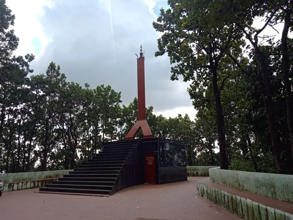
The British later raised twin obelisks at the site, one for Gillespie and his men and one for Balbhadra and his soldiers. The Khalanga War Memorial is now under the care of the Archaeological Survey of India.
Malaun and the Surrender of Amar Singh Thapa, 1815
The western campaign was Ochterlony’s. Working up the hills between the Sutlej and the Yamuna, he forced Amar Singh Thapa, the Nepalese commander in the west, to capitulate on 15 May 1815 after the fighting around Malaun. Amar Singh withdrew every Nepalese soldier east of the Kali and gave up all Nepal’s possessions from Kumaon to the Sutlej.
Kumaon became a British district, the Dun was administered and later formally annexed, and the rest of the hill country went back to the Rajas and chiefs from whom the Gorkhas had taken it.
The 1816 Campaign Towards Makwanpur
With the west lost, Nepal was ready to talk, but negotiations broke down twice over the cession of the Terai, the fertile lowland strip at the foot of the hills. Hastings offered to pay Nepal yearly for the Terai’s estimated value, and on that basis Nepal’s commissioners signed at Sugauli on 2 December 1815.
The Kathmandu court refused to ratify and in early February 1816 said it would resume the war. Ochterlony advanced towards Kathmandu and beat the Nepalese near Makwanpur on 28 February 1816. Nepal’s agent Chandra Shekhar Upadhyaya then brought the same treaty, now signed, to Ochterlony’s camp in the Makwanpur valley on the afternoon of 4 March 1816.
What Did the Treaty of Sugauli Say?
The Treaty of Sugauli is short: nine articles on about two printed pages. Here they are as Aitchison’s text states them, with place names in their modern spelling:
- Article 1: perpetual peace and friendship between the Company and the Raja of Nepal.
- Article 2: Nepal renounces all claim to the lands disputed before the war and accepts the Company’s sovereignty over them.
- Article 3: Nepal cedes in perpetuity (i) the lowlands between the Kali and the Rapti, (ii) the lowlands between the Rapti and the Gandak except Butwal Khas, (iii) the lowlands between the Gandak and the Kosi where British authority had been or was being introduced, (iv) the lowlands between the Mechi and the Tista and (v) the hill territory east of the Mechi, including the fort of Nagri and the Nagarkot pass; Gorkha troops to leave within 40 days.
- Article 4: pensions totalling two lakh rupees a year for the chiefs and barahdars (courtiers) who lose income from the ceded lands.
- Article 5: Nepal renounces all claim to the countries west of the Kali and engages never to have any concern with them or their people.
- Article 6: Nepal will not disturb the Raja of Sikkim, and any dispute with Sikkim goes to British arbitration.
- Article 7: Nepal will not employ any British subject, or the subject of any European or American state, without British consent.
- Article 8: accredited ministers of each state will reside at the other’s court.
- Article 9: the Raja ratifies within 15 days and the Governor-General within 20 days.
Read the list again for what isn’t there. There’s no British garrison paid for by Nepal, no tribute and no recruitment clause. Article 8 gave the Company a Resident at Kathmandu, and Britannica’s reading is exact: he had the status of an ambassador to an independent country, not of a controlling agent in a dependent Indian state.
Article 7 guards against rival Europeans training Nepal’s army, and Article 6 gave the Company a say in Sikkim’s affairs. The lands east of the Mechi and the Terai between the Mechi and the Tista, ceded under Article 3, were handed to Sikkim.
What Nepal Lost and What It Got Back
West of the Kali, Nepal lost Kumaon, Garhwal and the hill states up to the Sutlej, which Amar Singh had already given up and Article 5 made permanent. In the south and east it lost the Terai strips and the hills beyond the Mechi. The Terai loss didn’t last, and that’s the part most notes skip.
December 1816: The Terai Comes Back
On 8 December 1816 the Resident, Edward Gardner, offered to restore most of the Terai between the Kosi, the Gandak and the Rapti, including Butwal and Sheoraj, if Nepal gave up the two lakh rupees of pensions under Article 4. Nepal accepted on 11 December 1816. The trade was land for money, and the Terai further west, towards the Kali, went to Oudh.
The memorandum also admits that limits between the two states couldn’t be fixed without a survey, and asks commissioners on both sides to lay down a straight frontier.
1860: A Reward for 1857
The second return rewarded Nepal’s help in 1857, when it lent troops for the frontier districts and sent a force to help recapture Lucknow. By the treaty of 1 November 1860, signed by the Resident George Ramsay and Jung Bahadur Rana, the British restored the lowlands from the Kali to the Gorakhpur district that Nepal had ceded in 1815. A pillared line from the Kali (the Sarda) eastward became the boundary with Oudh, and Lord Canning ratified the treaty on 15 November 1860.
| Instrument | Date | What it did |
|---|---|---|
| Treaty of Sugauli | Signed 2 December 1815, ratified 4 March 1816 | Ended the war; took the Terai and the lands west of the Kali; Resident at Kathmandu |
| Memorandum and Nepal’s acceptance | 8 and 11 December 1816 | Returned most of the Terai between the Kosi and the Rapti; Article 4 pensions dropped |
| Treaty with Nepal | 1 November 1860 | Returned the lowlands from the Kali to Gorakhpur; fixed a pillared line with Oudh |
Gorkha Soldiers and the Company’s Army
The Company began recruiting Gorkha soldiers during the war, not because of the treaty. The Gurkha Museum at Winchester notes that recruiting provisions appeared in Amar Singh Thapa’s surrender agreement of 1815 and that four Gurkha battalions existed by the end of 1816. The Indian Army’s 1st Gorkha Rifles still carries the title The Malaun Regiment.
Recruitment became routine under the Rana family regime. Britannica describes a de facto alliance after 1860 in which Kathmandu allowed recruitment for the Gurkha units of the British Indian Army and accepted British guidance on foreign policy, while the British guaranteed the Rana regime. A formal Anglo-Nepal treaty followed in 1923.
Gorkha is the name of the hill kingdom, and Gurkha is the British spelling of the same word; Indian regiments use the first and the British Army the second. The Gorkha battalions belong in the wider story of how the East India Company built an army mostly of Indian soldiers.
Why Did the Treaty of Sugauli Matter?
The Treaty of Sugauli set the terms between the Company and Nepal for the next century:
- For Nepal: it lost everything from Kumaon to the Sutlej and with it the hope of a Himalayan empire, but it kept its independence and its own government, and received a Resident who was an ambassador, not a controller.
- For the Company: it gained the hills between the Kali and the Sutlej, with Kumaon and the Dun under British rule, and a settled northern frontier before Hastings’s war with the Marathas.
- For the map: it put the Kali on paper as Nepal’s western limit, the reference point for every later discussion of that boundary.
The treaty’s weakness is the other side of its brevity. It names rivers but not their sources, and it describes lowlands without surveyed lines, which is why the 1816 memorandum already needed commissioners to fix the frontier on the ground.
The Sugauli Boundary Today: Kalapani and Lipulekh
The treaty is back in the news because of one sentence in Article 5. It makes the Kali river the limit, and the governments of India and Nepal today disagree over the area around Kalapani, Lipulekh and Limpiyadhura, each citing history for its position. This note sets out each government’s position in its own official words and takes no side, and there is no map here on purpose.
Nepal’s position, as its Ministry of Foreign Affairs stated in May 2020, is that as per the Sugauli Treaty of 1816 all the territories east of the Kali (Mahakali) river, including Limpiyadhura, Kalapani and Lipu Lekh, belong to Nepal. It says it conveyed this in a diplomatic note of 20 November 2019 after India issued a new political map. In May 2020 Nepal released a revised official map, and on 13 June 2020 its House of Representatives passed a constitutional amendment to put that map in the national emblem.
India’s position runs through a series of Ministry of External Affairs statements:
- On India’s new map, the MEA said it had in no manner revised the boundary with Nepal and that boundary delineation was continuing under the existing mechanism.
- On 20 May 2020 it called Nepal’s revised map a unilateral act not based on historical facts and evidence, and said such artificial enlargement of territorial claims would not be accepted.
- On 13 June 2020, after the amendment passed Nepal’s lower house, it said the enlargement of claims was not based on historical fact or evidence and was not tenable.
- In August 2025, after India and China agreed to resume border trade through Lipulekh, it said that trade commenced in 1954, called Nepal’s claims neither justified nor based on historical facts and evidence, and said India remained open to constructive interaction with Nepal.
- On 4 May 2026, after Nepal sent diplomatic notes to India and China objecting to the Kailash Mansarovar Yatra via Lipulekh, it called such unilateral artificial enlargement of territorial claims untenable.
Both governments say the question should be settled through dialogue, and Nepal’s Prime Minister Balendra Shah has since said in Parliament that it shouldn’t be seen as one-sided, as the note on a new phase in India-Nepal relations explains. Border management goes on in parallel: the 14th India-Nepal Joint Working Group met on 20 and 21 August 2026 in Dehradun, the city of the war’s first battle, as the report on the Joint Working Group records.
The border itself is open. It runs 1,751 km across Uttarakhand, Uttar Pradesh, Bihar, West Bengal and Sikkim and is guarded on the Indian side by the Sashastra Seema Bal. The wider relationship is covered in the notes on India-Nepal relations and on Nepal itself.
How to Study the Treaty of Sugauli for Exams
The Anglo-Nepal War sits in modern Indian history under the expansion of British power, next to the Maratha and Mysore wars, and the Treaty of Sugauli returns in the India-Nepal part of GS Paper II. Prelims tests the facts, and History carries 184 of the 1,403 questions in the Prelims question bank.
Mains rarely asks about Nepal alone; it asks why the Company kept winning. Mains 2022 GS Paper I asked “Why did the armies of the British East India Company – mostly comprising of Indian soldiers – win consistently against the more numerous and better equipped armies of the then Indian rulers? Give reasons.” Nalapani, where the Company’s column lost its general and still won by cutting the water, is a precise example for that answer.
Revise these seven facts until they’re automatic:
- War formally declared 1 November 1814 under Lord Hastings (Earl of Moira).
- Khalanga (Nalapani): Gillespie killed; Balbhadra left the fort on 30 November 1814.
- Amar Singh Thapa capitulated to Ochterlony on 15 May 1815.
- Treaty signed 2 December 1815, ratified 4 March 1816 after the Makwanpur campaign.
- Article 5: Nepal renounces everything west of the Kali (Mahakali).
- Article 8: accredited ministers at each court; Edward Gardner the first Resident.
- Terai returned in December 1816 and again by the treaty of 1 November 1860.
The confusions come in pairs, and keeping them apart is half the work:
- Marquess of Hastings (Nepal war, 1814-16) and Warren Hastings (first Governor-General).
- Signing in 1815 and ratification in 1816; both years describe one treaty.
- The Kali (western limit) and the Mechi (eastern edge of the Nepal-Sikkim settlement).
- Gorkha recruitment (began in 1815 after Malaun) and the treaty’s nine articles (no recruitment clause).
The sharpest comparison is with the treaties the Company signed with Indian rulers, and the note on the subsidiary alliance gives the other half of this table:
| Point | Treaty of Sugauli (1815-16) | A subsidiary alliance treaty |
|---|---|---|
| British troops inside the state | None | A British force stationed and paid for by the ruler |
| Role of the Resident | Accredited minister, with ambassador’s status | A controlling influence at the court |
| Europeans in service | Barred without British consent (Article 7) | Barred without British consent |
| Foreign relations | Nepal kept its own, with limits on Sikkim | Handed to the Company |
| Land | Terai and western hills ceded; much of the Terai later returned | Territory often ceded to pay for the force |
Treat the Treaty of Sugauli as the Company war that ended without a subsidiary state. If you can explain why Nepal kept its independence while losing its western empire, and how one river clause from 1815 reaches today’s boundary question, the same two pages serve both the history paper and the international relations paper.
Frequently Asked Questions
What is the Treaty of Sugauli?
The Treaty of Sugauli is the peace treaty that ended the Anglo-Nepal War of 1814-16 between the East India Company and Nepal. Nepal gave up the Terai lowlands, the hills east of the Mechi and every claim west of the Kali river, and agreed to exchange accredited ministers, which brought a British Resident to Kathmandu. Nepal kept its independence.
When was the Treaty of Sugauli signed and ratified?
It was signed at Sugauli in present-day Bihar on 2 December 1815 and ratified on 4 March 1816. Nepal first refused to ratify it, and agreed only after a second British campaign under Ochterlony advanced towards Kathmandu in February 1816. That is why both 1815 and 1816 appear for the same treaty.
Who was the Governor-General during the Anglo-Nepal War?
The Governor-General was Francis Rawdon-Hastings, then the Earl of Moira and later the Marquess of Hastings, who took office in October 1813. He is a different person from Warren Hastings, the first Governor-General, who had left India long before.
What territories did Nepal lose under the Treaty of Sugauli?
Nepal lost the lands west of the Kali river, including Kumaon, Garhwal and the hill states up to the Sutlej, along with the Terai lowlands and the hills east of the Mechi. The lands east of the Mechi and the Terai between the Mechi and the Tista were handed to Sikkim.
What happened at the Battle of Nalapani?
Nalapani, also called Khalanga, was the siege of a hill fort near Dehradun in October and November 1814, the first battle of the war. Major-General Gillespie was killed leading the first assault, and the garrison under Balbhadra held out until the British cut its water supply; on the night of 30 November 1814 Balbhadra left the fort with 70 men. The British later built twin memorials there, one for each side.
Did the Treaty of Sugauli allow the British to recruit Gorkhas?
No. The treaty text in Aitchison’s official collection has nine articles and none of them deals with recruitment. The Company began enlisting Gorkha soldiers during the war, after Amar Singh Thapa’s surrender at Malaun in 1815, and by the end of 1816 it had four Gurkha battalions.
How is the Treaty of Sugauli linked to the Kalapani dispute?
Article 5 of the treaty makes the Kali river Nepal’s western limit. Nepal’s government holds that under the treaty all territories east of the Kali, including Limpiyadhura, Kalapani and Lipulekh, belong to Nepal. India’s government says Nepal’s claims are not based on historical facts and evidence and are untenable, and both sides say the question should be settled through dialogue.
Did Nepal get any land back after the Treaty of Sugauli?
Yes, twice. In December 1816 the British returned most of the Terai between the Kosi and the Rapti in exchange for Nepal giving up the pensions promised in Article 4. By the treaty of 1 November 1860 they returned the lowlands from the Kali to the Gorakhpur district as a reward for Nepal’s help during the revolt of 1857.
Practice Questions
Prelims
1. Consider the following statements about the Treaty of Sugauli: 1. It was signed at Sugauli in December 1815. 2. Nepal ratified it only after a second British campaign in 1816. Which of the statements given above is/are correct?
- (a) 1 only
- (b) 2 only
- (c) Both 1 and 2
- (d) Neither 1 nor 2
Answer: (c) The treaty is dated 2 December 1815, and Nepal ratified it on 4 March 1816 after Ochterlony’s advance towards Kathmandu.
2. Under the Treaty of Sugauli, which river became the western limit beyond which Nepal renounced all claims?
- (a) Mechi
- (b) Kali
- (c) Gandak
- (d) Tista
Answer: (b) Article 5 made Nepal renounce all claim to the countries west of the Kali (Mahakali).
3. Consider the following statements about the terms of the Treaty of Sugauli: 1. Nepal agreed to maintain a British subsidiary force at Kathmandu. 2. Nepal agreed not to employ any European or American subject without British consent. 3. Nepal agreed to refer its disputes with Sikkim to British arbitration. Which of the statements given above is/are correct?
- (a) 1 and 2 only
- (b) 2 and 3 only
- (c) 1 and 3 only
- (d) 1, 2 and 3
Answer: (b) Articles 7 and 6 contain statements 2 and 3; the treaty placed no British force in Nepal.
4. Who was the Governor-General of India during the Anglo-Nepal War of 1814-16?
- (a) Lord Wellesley
- (b) Lord Minto
- (c) Lord Moira (Marquess of Hastings)
- (d) Lord Amherst
Answer: (c) Francis Rawdon-Hastings, Earl of Moira, took office in October 1813 and conducted the war.
5. Consider the following pairs: 1. Nalapani: Balbhadra’s defense of the Khalanga fort 2. Malaun: Amar Singh Thapa’s capitulation to Ochterlony 3. Makwanpur: death of Major-General Gillespie. Which of the pairs given above is/are correctly matched?
- (a) 1 only
- (b) 1 and 2 only
- (c) 2 and 3 only
- (d) 1, 2 and 3
Answer: (b) Gillespie was killed at Nalapani in 1814, not at Makwanpur, where Ochterlony won in 1816.
Mains
- Why did the armies of the British East India Company – mostly comprising of Indian soldiers – win consistently against the more numerous and better equipped armies of the then Indian rulers? Give reasons. (10 marks, 150 words) Previous year: Mains 2022, GS Paper I.
- The Anglo-Nepal War of 1814-16 was won in the western hills but settled over the Terai. Discuss. (15 marks, 250 words)
- Examine how the Treaty of Sugauli differed from the subsidiary alliance treaties that the East India Company signed with Indian rulers. (10 marks, 150 words)
- Trace the revisions to the Sugauli settlement in 1816 and 1860. What do they reveal about the Company’s frontier policy in the Himalaya? (15 marks, 250 words)
- A treaty signed in 1815 still shapes India-Nepal relations. Examine this with reference to the Kalapani and Lipulekh question and the official positions of both governments. (15 marks, 250 words)
Tell Google you want more of this.
Add Anantam IAS as a preferred sourceOne tap, and this site shows up more often in your own Top Stories, AI Overviews and AI Mode. Remove it any time.