Most aspirants can name Jog Falls as a tall waterfall in Karnataka and stop there, which is exactly why the tricky follow-ups catch them out. Which river? Which segments? Why is it a torrent in August and a thin ribbon in February? The honest answer is that Jog Falls is not really one waterfall, and it is not fully wild anymore either. It is a set of four distinct drops on the Sharavati River, and how much water pours over them on any given day is decided not by rain alone but by a dam upstream and a hydroelectric station that both want the same water. Once you hold those two facts together, the river, the falls, the power and the politics all click into a single picture, and that is the picture examiners keep testing.
Where Jog Falls is and what makes it special
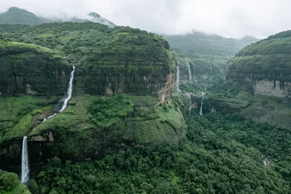
Jog Falls is a segmented waterfall on the Sharavati River in the Western Ghats, in the Sagara taluk of Shivamogga (Shimoga) district, Karnataka, right on the boundary with Uttara Kannada district. The water plunges roughly 253 metres (about 830 feet) in a near-vertical drop, which places it among India’s tallest plunge waterfalls. It is also known locally as Gerosoppa Falls or Jogada Gundi.
The word to fix first is plunge, because it explains why Jog gets so much attention. A plunge waterfall is one where the water leaves the rock face and falls freely through the air, without sliding down the slope, so it hits the pool below as an unbroken column. That is different from a cascade, where water tumbles down a staircase of rock, or a tiered fall that drops in stages. India actually has waterfalls that are taller by total height, such as Kunchikal in Karnataka, but many of those descend in steps or run dry; Jog’s appeal is the sheer free fall when the river is full. If you are building a mental list of the country’s waterfalls of India, keep Jog in the plunge category and you will answer the comparison questions correctly. It is often listed alongside the country’s largest natural superlatives precisely because of that dramatic single drop.
Here is the part that trips people up. Jog is spectacular, but it is not the tallest waterfall in India, and it is not a continuous curtain like Niagara. It is four separate falls side by side, each with its own character and its own name, and in the dry months some of them shrink to almost nothing. Getting that nuance right is what separates a real answer from a postcard caption.
The Sharavati River: a short, west-flowing river of the Ghats
The Sharavati is a small but important west-flowing river that rises and dies entirely within Karnataka. It originates at Ambutirtha near Nonabur in Thirthahalli taluk, Shivamogga district, flows roughly 128 km, and empties into the Arabian Sea at Honnavar in Uttara Kannada. Jog Falls sits on its middle course, where the river reaches the edge of the plateau and drops off the Western Ghats escarpment.
To see why the falls exist at all, you have to understand the shape of the land. Peninsular India is an old, tilted block, and the Western Ghats form its western edge, rising steeply from the coastal plain before sloping gently eastward. Rivers born on the plateau either run east across the whole peninsula to the Bay of Bengal, like the Krishna and Cauvery, or they take the short, steep route west to the Arabian Sea, like the Sharavati. The west-flowing rivers are short and energetic because they fall a long way over a short distance, and where they meet the sharp escarpment of the Ghats, they produce waterfalls. So Jog Falls is not a geological accident; it is the predictable result of a young, steep, west-flowing river meeting the plateau’s edge. If you have studied the peninsular plateau and how its western rim behaves, the location of India’s big western waterfalls stops being a list to memorize and becomes something you can reason out. The same escarpment logic governs the broader drainage patterns of southern India.
This is also the standard mistake in Prelims: people place Jog on the wrong river. It is the Sharavati, not the Kali, not the Tunga, not the Kaveri. Anchor the river and the district together, Sharavati and Shivamogga, and you have the two facts that questions actually turn on.
The Sharavati Valley around and below the falls is itself worth a line, because it explains why any project here draws such heat. The valley is thick evergreen rainforest, part of the biodiversity-rich Western Ghats that is recognised as a global hotspot, and it shelters the endangered lion-tailed macaque, the great pied hornbill and other Ghats endemics. So the river does two things at once: it carves the country’s most famous plunge waterfall, and it runs through one of the most sensitive forest tracts in southern India. That double identity, spectacular resource and fragile ecosystem, is the tension that runs through every modern decision about the Sharavati, and it is why a question about Jog Falls is rarely just a geography question.
The four segments: Raja, Rani, Rover and Rocket
Jog is famous for splitting into four distinct falls as it drops, each named and each behaving differently. This is the single most quotable feature of Jog Falls, and it is worth learning by character, not just by name, because the descriptions themselves are the memory hooks.
| Segment | Character | How to remember it |
|---|---|---|
| Raja (the King) | The tallest, most powerful drop, an unbroken column of water falling straight down | The main fall, dignified and vertical, the “king” of the four |
| Rani (the Queen, also called the Lady of the Falls) | Water descends more gently in white, foamy, dancing sheets over the rock | Graceful and quiet beside the King, the “queen” |
| Rover (the Roarer) | Strikes a ledge partway down and crashes onward with a loud roar | Noisy and restless, it “roars” as it hits the rocks |
| Rocket | Shoots out of an opening in rapid spurts, as if fired from a nozzle | Bursts out in jets, like a “rocket” |
Picture the four standing in a row across the cliff. Raja falls clean and vertical, the postcard image everyone knows. Rani drifts down beside it in soft white folds. Rover hits an obstruction and thunders. Rocket spurts out in bursts. The reason this matters beyond trivia is that the segmentation depends on how much water is in the river. In full monsoon flow, the four merge into one broad, roaring sheet and the individual characters blur together; in the lean season, some segments dwindle to trickles and the “four falls” become clearly separate, sometimes barely there. So the number four is not fixed scenery, it is a description of a particular flow regime, and that dependence on flow is the bridge to the real story of Jog: the dam.
The Linganamakki dam and why the falls are no longer wild
The Linganamakki dam, completed in 1964 across the Sharavati in Sagara taluk, is the reason Jog Falls today is a managed waterfall rather than a purely natural one. The dam impounds the Sharavati into a large reservoir upstream of the falls, and that stored water is used mainly to generate electricity, not to feed the falls. In simple terms, the river is caught and held before it ever reaches the cliff, and only what the reservoir spills or releases goes over the edge.
This is the fact that reframes everything. Before the dam, Jog Falls flowed according to the river’s own rhythm: heavy in the monsoon, lighter in the dry months, but always fed by the natural Sharavati. After Linganamakki, the natural flow is intercepted and diverted through pipes and tunnels to power stations, and the falls receive water chiefly when the reservoir is full enough to overflow, which in practice means the peak of the southwest monsoon. For much of the rest of the year the water that would have thundered over Jog is instead spinning turbines. A dam built to store and generate is doing exactly the opposite job of a river left to fall freely, and the waterfall pays the price in the dry season. India’s larger hydro story, from the Koyna dam in the Ghats to disputes over reservoirs like the Almatti dam on the Krishna, is full of this same trade-off between stored water and everything downstream that the water used to do.
There is a live tension here that is worth stating plainly. Tourism interests and locals often want water released over the falls on weekends and holidays so visitors see the full spectacle, while the power authorities want to conserve every drop in the reservoir for generation, especially in a dry year. That standoff, between a waterfall as a tourist asset and a waterfall as a byproduct of a power scheme, is the honest modern condition of Jog Falls.
Sharavati hydroelectric power: the engine behind the diversion
The water held back at Linganamakki feeds one of Karnataka’s oldest and largest hydroelectric complexes, and that is precisely why the reservoir guards its water so jealously. The Sharavati’s steep fall through the Ghats gives it exactly what hydropower needs, a large drop over a short distance, so the same geography that makes the waterfall dramatic also makes the river valuable for electricity.
The historic station here is the Mahatma Gandhi Hydroelectric Station, one of the early hydel stations in the region, and it was later joined by the much larger underground Sharavati Generating Station, with an installed capacity above 1,000 MW, which for decades has been one of Karnataka’s most important sources of power. The logic of a hydel plant is straightforward: send falling water through a turbine, and the energy of the drop turns a generator. The taller the drop and the steadier the flow, the more power you get, which is why the Sharavati, with its long plunge off the plateau, was dammed and tunnelled rather than left to spill over the cliff. To see where this fits in the national picture, it helps to read Jog and Linganamakki as one node in India’s wider hydroelectric power story, part of the country’s push toward renewable energy that also raises hard questions about submerged forests and displaced people.
That value is now driving a new controversy. A proposed Sharavati Pumped Storage Project, a large scheme meant to store energy by pumping water uphill and releasing it to generate at peak demand, would sit inside an ecologically sensitive stretch of the Western Ghats that is home to the endangered lion-tailed macaque. Conservationists warn about tunnelling and forest loss in the Sharavati Valley wildlife area; the power sector argues the country needs exactly this kind of storage to firm up solar and wind. It is the old Jog dilemma in a new form: how much of a living river valley do you convert into an energy machine.
Why the monsoon decides everything at Jog
Whether Jog Falls roars or trickles on the day you visit comes down to one variable above all: the southwest monsoon. Because the dam holds the river back, the falls get their big flow chiefly when the reservoir fills and overflows, and the reservoir fills when the monsoon dumps heavy rain on the Western Ghats catchment between roughly June and September.
The mechanism is worth spelling out because it explains the timing. The Western Ghats stand directly in the path of the moisture-laden southwest monsoon winds coming off the Arabian Sea. The winds are forced up over the Ghats, cool, and unload enormous rainfall on the western slopes, which is why this belt is one of the wettest in India. That rain swells the Sharavati and refills Linganamakki, and once the reservoir is brimming, water spills toward the falls. So the best time to see Jog in full fury is the tail of the monsoon, around August and September, when the catchment is saturated and the reservoir overflows. By the dry months the reservoir is being drawn down for power and the falls thin out. If your grasp of the Indian monsoon mechanism is solid, the seasonality of Jog Falls is not a separate fact to memorize, it is a direct consequence of orographic rainfall on the Ghats meeting a reservoir that only spills when full.
This monsoon dependence, layered on top of the dam, is the complete explanation for the puzzle we started with. Jog is a torrent in September because the Ghats are drenched and the reservoir overflows; it is a ribbon in February because the rain has stopped and the water is being saved for electricity. And in a weak-monsoon year, when the Ghats get less rain, the reservoir may barely fill, so even the peak season disappoints, a reminder that the falls now live entirely at the mercy of both the rain and the dam operator’s ledger.
How to study and remember Jog Falls
Treat Jog Falls as a small system, not a single fact, and it becomes almost impossible to forget. The chain runs: Sharavati River, west-flowing, Shivamogga district, Western Ghats escarpment, four segments, Linganamakki dam, hydel power, monsoon-fed spill. Learn it as a story and each link cues the next.
For revision, lock down the non-negotiables first. The river is the Sharavati; the district is Shivamogga (Shimoga), on the Uttara Kannada border; the drop is about 253 metres; the four segments are Raja, Rani, Rover and Rocket; the controlling dam is Linganamakki (1964); the power is the Sharavati hydroelectric scheme. Those six facts answer almost every objective question. For Mains and interviews, add the tension: the falls are diminished for most of the year because the water is used for power, and there is a running conflict between tourism, ecology and electricity, now sharpened by the proposed pumped storage project in lion-tailed macaque habitat.
A quick way to keep it in context is to link Jog to two neighbours in your notes. It belongs with the other big waterfalls of the Western Ghats and the peninsular west coast, and it sits in the same Karnataka geography you meet in the history of figures like Kittur Rani Chennamma. Group it with the broader river systems of India and the west-flowing rivers in particular, and it stops being an isolated tourist spot and becomes a clean illustration of how relief, drainage and human engineering interact. That framing is what turns a nice photograph into an answer you can defend.
Frequently Asked Questions
Which river forms Jog Falls?
Jog Falls is formed by the Sharavati River, a west-flowing river of Karnataka that rises at Ambutirtha in Thirthahalli taluk and drains into the Arabian Sea at Honnavar. The falls lie on its middle course where the river drops off the Western Ghats escarpment.
In which state and district is Jog Falls located?
It is in Karnataka, in the Sagara taluk of Shivamogga (Shimoga) district, on the boundary with Uttara Kannada district, within the Western Ghats.
What are the four segments of Jog Falls?
The four falls are Raja (the tall, unbroken main column), Rani (the gentle, foamy Lady of the Falls), Rover (the Roarer, which crashes off a ledge), and Rocket (which shoots out in rapid spurts).
How tall is Jog Falls?
The water drops roughly 253 metres, about 830 feet, in a near-vertical plunge, making it one of India’s tallest plunge waterfalls, though not the tallest overall.
Why does Jog Falls have so little water for much of the year?
Because the Linganamakki dam upstream stores the Sharavati’s water for hydroelectric power. The falls get their full flow mainly when the reservoir fills and overflows during the peak southwest monsoon, around August and September, and thin out in the dry season.
Is Jog Falls the highest waterfall in India?
No. It is among the tallest plunge waterfalls, but by total height some Indian waterfalls, including Kunchikal in Karnataka and Nohkalikai in Meghalaya, are higher. Jog’s fame rests on its dramatic single drop when in full flow.
When is the best time to visit Jog Falls?
The tail of the monsoon, roughly August to September, when the catchment is saturated and the Linganamakki reservoir overflows, sending the maximum water over all four segments.
What is the Linganamakki dam’s role?
Completed in 1964, it dams the Sharavati into a large reservoir and diverts the stored water to the Sharavati hydroelectric stations. It effectively controls how much water reaches the falls, which is why Jog is now a managed rather than a fully natural waterfall.
Practice Questions
1. Jog Falls is located on which of the following rivers?
a) Kali
b) Sharavati
c) Tunga
d) Netravati
Answer: b) Sharavati
2. Consider the following statements about Jog Falls:
- It lies in the Shivamogga district of Karnataka.
- Its flow is regulated by the Linganamakki dam.
- The Sharavati is an east-flowing river that joins the Bay of Bengal.
Which of the statements given above are correct?
a) 1 and 2 only
b) 2 and 3 only
c) 1 and 3 only
d) 1, 2 and 3
Answer: a) 1 and 2 only
3. The four segments of Jog Falls are correctly named as:
a) Raja, Rani, Rover, Rocket
b) Raja, Rani, River, Rapid
c) King, Queen, Roarer, Ranger
d) Raja, Rani, Ridge, Rocket
Answer: a) Raja, Rani, Rover, Rocket
4. Jog Falls owes its existence chiefly to which geographical factor?
a) A rift valley on the east coast
b) A west-flowing river dropping off the Western Ghats escarpment
c) Glacial melt from the Himalayas
d) A delta formed on the Arabian Sea coast
Answer: b) A west-flowing river dropping off the Western Ghats escarpment
5. Which of the following best explains why Jog Falls carries far less water in the dry season?
a) The Sharavati dries up completely every winter
b) The river changes course seasonally
c) Water is stored at the Linganamakki reservoir and diverted for hydroelectric power
d) The falls freeze in the dry months
Answer: c) Water is stored at the Linganamakki reservoir and diverted for hydroelectric power
Mains-style questions
- Explain how the relief and drainage of the Western Ghats give rise to major west-flowing waterfalls such as Jog Falls. Illustrate with the example of the Sharavati River.
- “Jog Falls is today a managed waterfall rather than a natural one.” Discuss this statement with reference to the Linganamakki dam and the Sharavati hydroelectric scheme.
- Examine the trade-offs between hydroelectric power generation, tourism, and ecological conservation in the Sharavati Valley, with reference to the proposed Sharavati Pumped Storage Project.
- Analyse the role of the southwest monsoon in determining the seasonal flow of waterfalls in the Western Ghats. Why does heavy orographic rainfall not translate into a year-round flow at Jog Falls?
- Discuss the significance of west-flowing peninsular rivers for hydropower in southern India, using the Sharavati as a case study.
Jog Falls rewards the aspirant who refuses to treat it as a single pretty fact. See it as a system, a young west-flowing river meeting the edge of an ancient plateau, split into four falls, then caught by a dam and rationed between electricity and spectacle, and the whole cluster of geography, environment and governance questions falls into place. The most useful thing you can carry out of this is not the height in metres but the reasoning: relief creates the drop, the monsoon fills the river, and human choices about power decide how much of that water the world actually gets to see.
Tell Google you want more of this.
Add Anantam IAS as a preferred sourceOne tap, and this site shows up more often in your own Top Stories, AI Overviews and AI Mode. Remove it any time.