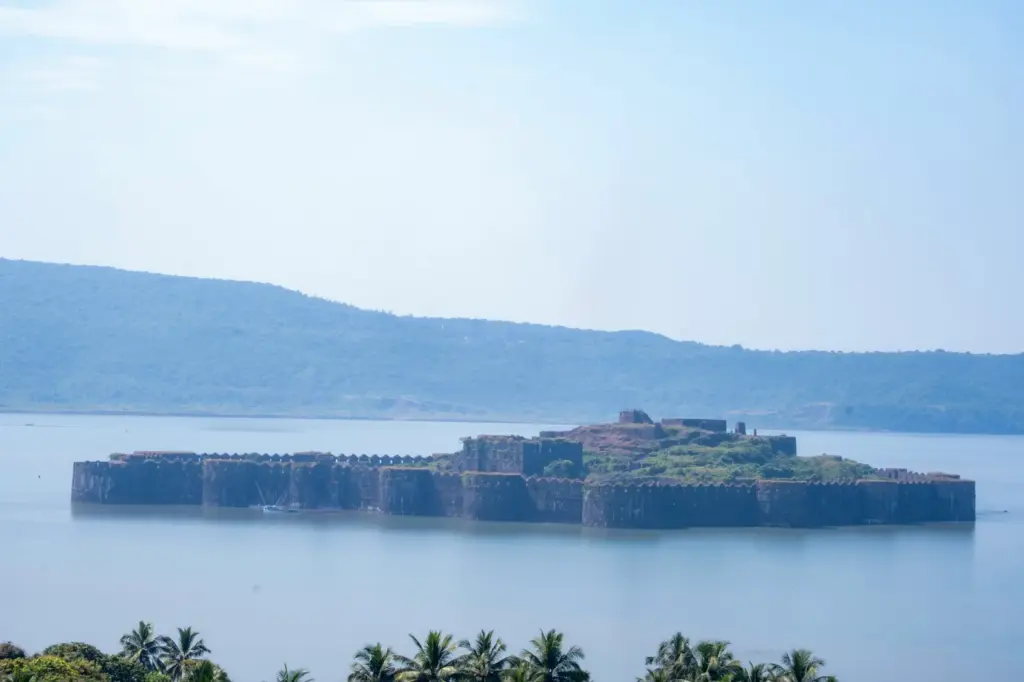
Janjira Fort is an island sea fort at the mouth of the Rajapuri creek, off the town of Murud in Raigad district of Maharashtra. For about three centuries it was the seat of the Siddis, Muslims of Abyssinian, that is north-east African, descent, who first held it for the sultans of Ahmadnagar and ended as the Nawabs of a small princely state that merged with Bombay Province in 1948. Its reputation rests on one record: Maratha armies besieged it for more than a century, under Shivaji and then under Sambhaji, and never took it.
Three things about Janjira trip people up. The name is simply the Marathi form of the Arabic jazira, an island, so “Janjira Fort” really means island fort. The dates get muddled, because popular accounts credit Malik Ambar with a stone fort in 1567 while the dated stone over the gate reads 1694. And because Sindhudurg and Suvarnadurg made the 2025 UNESCO list, many assume Janjira did too. It didn’t.
Where Janjira is and what it is known for
The fortified island lies just inside the entrance of the Rajapuri creek on the Konkan coast, about half a mile from the Rajapuri shore, and visitors still reach it by sailboat from the Rajapuri jetty. It’s roughly oval, and at high tide its walls rise straight out of the water to a height of 45 to 50 feet. Two miles to the north-west, on another rock in the bay, stands Padmadurg, a Maratha fort that commands the same creek entrance.
| Fact | Detail |
|---|---|
| Location | Island at the mouth of the Rajapuri creek, off Murud, Raigad district, Maharashtra |
| Held by | The Siddis, first as captains for Ahmadnagar, later as Nawabs of Janjira State |
| Present walls | Begun in 1694 (dated stone over the gate) and finished in 1707 under Sidi Surul Khan |
| Type | Island sea fort with nineteen bastions, as counted by the Kolaba gazetteer |
| Sieges survived | Shivaji (1661 to 1670 and 1676), Sambhaji (1682), a Maratha governor of the Konkan (1760) |
| Named cannons | Kalal Bangadi, Chavri and Landa Kasam |
| Protection status | Archaeological Survey of India (centrally protected) |
| UNESCO status | Not inscribed, and not a component of the 2025 Maratha Military Landscapes of India |
| Known for | Never taken by siege; the Siddi naval power of the Konkan coast |
Who the Siddis were and how they got Janjira
The Siddis came to the Deccan’s courts as soldiers and sailors from north-east Africa, many of them brought as slaves and then raised to high command. The gazetteers explain both their names. Habshi comes from the Arabic word for the people of Abyssinia, and Sidi began as a term of respect, a worn-down form of Syed. Under the Bahmani kingdom and its successor sultanates, Siddi officers rose far enough to form a community of their own on the Konkan coast.
How they first got the island is where record and tradition part. A history of Ahmadnagar credits Malik Ahmad, founder of the Nizam Shahi dynasty, who ruled from 1490 to 1508, with first placing Abyssinians as captains of the island fort. There was certainly a fort on the island by 1538, when the Portuguese captain Dom Joao de Castro described it.
The Koli fort and the story of the boxes
The popular origin story is a tradition, and the gazetteer records it as one. According to an account in Clunes’ Itinerary, the island was held by Ram Patil, a Koli captain, when a certain Perim Khan and a few other Abyssinians arrived dressed as merchants with a shipload of great boxes said to hold wine and silk. Ram Patil let them land and the garrison drank the wine. Then armed men climbed out of the boxes and took the fort.
It’s a good story, and it may hold a memory of a Koli fishing community on the island. It is still a story from a single later account, and no dated source confirms Ram Patil or the boxes. Treat it the way you’d treat any siege told as a trick: remember it as tradition, not as the founding date.
From governors to rulers
Local records name the first Siddi governor as Sidi Sirul Khan, appointed in 1618. In 1621 he was followed, after a short interval, by Sidi Ambar, called Sanak, “the Little”, to tell him apart from the great Malik Ambar who ran Ahmadnagar until his death in 1626. That pair of Ambars is the likely root of the popular belief that Malik Ambar built Janjira.
After Ahmadnagar fell, its Konkan passed to Bijapur, and the leading Abyssinian officer of the Bijapur fleet was granted the coast from Nagothana to the Bankot river with the rank of wazir. The Siddi constitution was unusual. On a wazir’s death the first officer of the fleet succeeded, not the dead man’s son, which made the island a naval command more than a dynasty.
Why Shivaji could not take Janjira
The direct answer: Shivaji could take the mainland around Janjira but not the island itself, because he lacked the siege guns to breach its walls and the fleet to cut off its supplies by sea. The record shows him trying hard for more than a decade.
The sequence, from the 19th-century gazetteer of Janjira State:
- 1648: Chhatrapati Shivaji Maharaj wins three Kolaba forts from the Siddi, among them Rairi, the hill that became Raigad.
- 1659: A Maratha force invades the Siddi’s territory and is defeated by the Siddi commander Fateh Khan.
- 1661: In the rains, before Bijapur can send help by sea, Shivaji takes Danda-Rajpuri on the mainland. He opens batteries against Janjira but, for want of guns and gunners, makes no impression.
- 1661 to 1670: He batters Janjira every season with little success.
- 1670: A heavy assault, combined with offers to Fateh Khan, nearly works. Fateh Khan decides to surrender, but three of his Siddi officers, Sambal among them, stop him.
- 1676: Shivaji is again besieging Janjira when a Siddi fleet arrives to relieve it.
The 1670 crisis changed the Siddis’ politics. With Bijapur failing to help, they turned to the Mughal Empire, and Siddi commanders went on to serve as admirals of the Mughal fleet. A fort that the Marathas couldn’t take now had the empire behind it.
Janjira’s reputation was already made. The gazetteer records that English factors in Bombay wrote to their council at Surat advising it to give up Bombay and take Janjira instead. Imagine the company that held Bombay’s harbor wanting to swap it for a rock off Murud. That’s how strong the island looked from the sea.
Sambhaji’s siege of 1682 and the channel he tried to fill
The most serious attempt came under Chhatrapati Sambhaji Maharaj in 1682. His general Dadaji Raghunath Deshpande was sent to besiege Janjira with the promise of a place among the eight chief ministers if he took it. Then Sambhaji himself joined the siege from Raigad with some 20,000 men and battered the island for thirty days.
It came close. The bombardment damaged the fortifications, and a plot to hand over the fort through one Khandoji Farjud nearly succeeded before it was discovered. The garrison under Sidi Khairiyat held on, sheltering behind a rock in the middle of the island, while the Siddi admiral Kasim cleared Sambhaji’s fleet from the bay.
Then Sambhaji tried the boldest idea of all. He began filling the channel between the island and the mainland with stones and fragments of rock, to build a causeway his troops could march along. The gazetteer puts the channel at about 800 yards broad. Before the work was done he was called away to face a Mughal cavalry force, and after he left Dadaji gave up the filling. A last boat attack was beaten off with the loss of 200 men.
The causeway is worth a moment’s thought. It was the right idea, since it would have turned an island fort into a land fort, but it needed months of labor under fire, and a Mughal threat on land cost him the time.
The Marathas did leave a permanent fort in the bay. The Kolaba gazetteer dates Padmadurg, also called the Kasa or Kansa fort, to about 1693, when a Persian chronicle lists it among newly built Maratha forts. It stands on a rock in three fathoms of water two miles north-west of Janjira, with six bastions. It never displaced the Siddis, though: Janjira stayed theirs, and its walls were completed in 1707 under Sidi Surul Khan.
The Peshwas, the British and the end of Janjira State
The 18th century brought the Peshwas against Janjira, and the Siddis survived them by treaty and by alliance. In 1713 the Peshwa Balaji Vishwanath and Kanhoji Angria of Kolaba combined against the Siddis and forced Surul Khan to submit, and a treaty in 1714 settled terms. A treaty of 1736 then fixed the territory left to the Siddis.
The decisive rescue came from outside. In 1760 the Maratha governor of the Konkan, Ramaji Pant, helped by a Portuguese corps, took the Siddi lands on the mainland and besieged the island. After the Maratha disaster at the Third Battle of Panipat in January 1761, the English hoisted the British flag at Janjira and made the Marathas respect it, and a treaty that September restored the Siddi territory.
From then on Janjira was a client state, and its independence shrank step by step:
- 1834: The British declare Janjira subject to British power and abolish its mint, which had been issuing debased coins.
- 1869: The Nawab loses criminal jurisdiction, and a Resident British officer takes political charge.
- 1948: Janjira, listed in the White Paper on Indian States among the states of the Deccan States Agency, merges with Bombay Province; those states signed merger agreements from 19 February 1948, and all except Kolhapur were integrated with Bombay.
At the merger Janjira State covered about 326 square miles with a population of just over 1 lakh. The gazetteer records a salute of nine guns for its ruler. The gazetteer’s closing judgment is blunt: the Siddis outlasted the Marathas partly by skillfully cultivating the English or the Portuguese. Janjira was never stormed, but it wasn’t the walls alone that kept it.
How the sea and the creek defended Janjira
Janjira is a lesson in coastal geography before it’s a lesson in masonry. The island sits just inside the mouth of the Rajapuri creek, one of the many creeks that cut the Konkan coastal plain. The creek winds inland to the south-east until it looks like a lake, and the rocky island controls its entrance.
The sea did four jobs for the defenders:
- It kept siege guns at a distance. Batteries on the Rajapuri shore had to fire across water, and in 1661 Shivaji, short of guns and gunners, made no impression at all.
- It moved the fight to the tide. The gazetteer quotes a sailing directory putting the rise of the spring tide at twelve feet, so the wall base that dries at low water is under the sea at high water. An assault by boat had to reckon with a rock foundation and a wall rising 45 to 50 feet from the water.
- It gave the garrison a supply line. A fort that could be reached by sea could be fed by sea, as long as its own fleet held the bay, and the Siddi fleet usually did.
- It closed with the monsoon. The monsoon shut the sea to relief fleets, which is exactly why Shivaji struck at Danda-Rajpuri during the rains of 1661, before Bijapur could send help.
One more element made the sea safe to live beside: fresh water. The Raigad district administration notes two small natural freshwater lakes inside the fort, and the Nawab’s palace was built around a large cistern. Salt water on every side and sweet water inside is the combination that let the garrison sit out a thirty-day bombardment.
Janjira is also the useful contrast to the Maratha island forts. The 2025 World Heritage listing includes three island forts built or held by the Marathas, and Janjira, which they never held, is not among them.
Janjira’s walls, gates and guns
The best way to understand the fort is to arrive as an attacker would, by boat from Rajapuri.
The main gate is on the east side, facing Rajapuri, with steps leading down to the water. The state tourism department notes that it is set so that it only becomes visible when a boat is within about 40 feet, and a carving beside it shows a beast gripping elephants in its claws. Above the gate, near the heavy iron-studded doors, a white stone carries the date 1111 Hijri, AD 1694, which the Kolaba gazetteer reads as the start of the present walls. They were finished in 1707 under Sidi Surul Khan.
The walls are battlemented and strongly loopholed. A loophole is a narrow slit through a wall that lets a defender fire out while showing almost nothing to fire back at. Their faces are covered by nineteen bastions, each about eighty feet across and thirty deep, set about ninety feet apart. Counts differ with what gets counted: the state tourism department speaks of 26 artillery towers.
On the west, facing the open sea, a small postern, a back gate for secret movement, opens onto a semicircular masonry platform about twenty feet above the water, covered by the bastions. The district administration calls it the Darya Darwaza, the sea gate. In a siege it was the door through which boats could slip supplies in or messengers out on the side no land battery could reach.
The bastions still carry guns of Indian and European make. Three large cannons are named in the district’s account, and they were feared for their range:
- Kalal Bangadi
- Chavri
- Landa Kasam
Inside the walls stand the ruins of a large cut-stone mansion and the Nawab’s palace, built around a cistern. A mosque and the two freshwater lakes complete the interior. Much of the interior is ruined for a reason the gazetteer records precisely: in 1860 a fire burnt more than half of it and destroyed a mass of state papers. The walls survived the fire, which is why the fort still looks whole from the sea.
Janjira today: ASI protection and a missing UNESCO tag
Janjira Fort is a centrally protected monument of the Archaeological Survey of India, and a busy one. ASI’s ticket figures for 2024-25 record 247,499 visitors, against 341,086 at Raigad and 138,657 at Lohagad. A quarter of a million people a year, all arriving by boat onto a ruin in salt water, is a different conservation problem from a hill fort with a staircase.
It is not a World Heritage Site. The UNESCO listing of the Maratha Military Landscapes of India, inscribed on 11 July 2025 at the 47th session of the World Heritage Committee, has twelve components, and Janjira isn’t one of them. The site’s current-affairs note on the inscription lists them, and the UNESCO World Heritage Sites in India guide covers the rest of India’s list.
The absence makes sense once you know the history. The 2025 property celebrates the military system the Marathas built. Janjira is the fort that system failed to take, and its builders were the Siddis. Leaving it out isn’t a judgment on its importance, and an answer that says “Janjira is part of the Maratha UNESCO site” will be marked wrong.
How to study Janjira for exams
Janjira reaches into more of the syllabus than its size suggests:
- Medieval history: the Siddis and the limits of Maratha power at sea.
- Society and culture: the Siddis as a chapter of India’s African diaspora.
- Modern history: British paramountcy over a small maritime state and its merger in 1948.
- Geography: the Konkan coast’s creeks and tides as a defensive system.
The Maratha thread is asked in its broadest form. History Optional 2026 Paper I set the question “Trace the trajectory of Maratha polity from Shivaji to Peshwa Balaji Baji Rao. What was the impact of the Third Battle of Panipat (1761) on the Maratha State? Analyze.” Janjira gives that answer a sharp edge: the polity that took so many hill forts couldn’t take one island, and Panipat is the hinge on which the English stepped in to protect it.
History Optional 2023 Paper I asked the reverse question, “The Marathas posed a significant threat to the integrity of the Mughal Empire. Discuss.” Janjira belongs in that answer too, because the Siddis’ move to Mughal service after 1670 put an imperial fleet on the Maratha coast.
In Prelims, 94 of the 1,403 questions from 2013 to 2026 in our Prelims question bank are tagged art and culture, about one in fifteen, and a status trap like Janjira’s UNESCO position is the kind of statement those questions test.
The facts worth carrying into revision:
- Janjira means island, from the Arabic jazira.
- The Siddis were of Abyssinian descent; the first Siddi governor on record was appointed in 1618.
- The present walls date from 1694 to 1707, with nineteen bastions in the gazetteer’s count.
- Shivaji failed from 1661 to 1670 and again in 1676; Sambhaji tried to fill the channel in 1682.
- Padmadurg is the Maratha fort two miles away in the same bay, dated to about 1693.
- The British flag went up in 1761, and Janjira merged with Bombay in 1948.
- ASI protected, and not a UNESCO component.
Keep the confusions apart by pairing them. Malik Ambar was Ahmadnagar’s regent; Sidi Ambar “the Little” was a Janjira governor. Janjira was Siddi; the island forts in the 2025 listing were Maratha forts. Padmadurg was a Maratha fort commanding the same creek, not a rebuilt Janjira.
| Fort | Built or held by | Setting | Protected by | UNESCO 2025 |
|---|---|---|---|---|
| Janjira | Siddis | Island at a creek mouth | ASI | Not a component |
| Padmadurg | Marathas, about 1693 | Rock in the bay, two miles off Janjira | Not established | Not a component |
| Khanderi | Marathas | Island fort | State Directorate of Archaeology and Museums | Component |
| Suvarnadurg | Marathas | Island fort | ASI | Component |
| Sindhudurg | Marathas | Island fort | ASI | Component |
Janjira is the best corrective in the syllabus to the idea that forts fall to the stronger army. The Marathas were stronger on land for most of a century and still failed here, because the island turned the contest into one of sea power. Remember that and your answers on Maratha power and on heritage lists will both get sharper.
Frequently Asked Questions
Who built Janjira Fort?
The present walls of Janjira Fort were built by its Siddi rulers, begun in 1694 according to a dated stone over the gate and finished in 1707 under Sidi Surul Khan. A fort stood on the island much earlier, since a Portuguese captain described one in 1538. Popular accounts crediting Malik Ambar with building it in 1567 are not supported by the gazetteer’s dated evidence.
Where is Janjira Fort located?
Janjira Fort stands on an island at the mouth of the Rajapuri creek, off the town of Murud in Raigad district, Maharashtra. It lies about half a mile from the Rajapuri shore on the Konkan coast. Visitors reach it by boat from the Rajapuri jetty.
Who were the Siddis of Janjira?
The Siddis were Muslims of Abyssinian, or north-east African, descent who came to the Deccan as soldiers and sailors and rose to high command. They held Janjira first as captains for the Ahmadnagar sultans, then under Bijapur and the Mughals. Their rulers later became the Nawabs of Janjira State.
Why could the Marathas never capture Janjira?
The island kept siege guns at a distance across the water, and its walls rose 45 to 50 feet from the sea at high tide. The Siddis could be supplied by sea as long as their fleet held the bay, and they had fresh water inside the fort. They also survived by alliances, first with the Mughals and later with the English.
Is Janjira Fort a UNESCO World Heritage Site?
No. Janjira is not one of the twelve components of the Maratha Military Landscapes of India inscribed in 2025, and it is not inscribed separately. The listing does include three Maratha island forts, among them Sindhudurg and Suvarnadurg.
What are the famous cannons of Janjira Fort?
The best-known cannon on Janjira’s bastions is Kalal Bangadi, and two other large guns, Chavri and Landa Kasam, are named alongside it. The Raigad district administration notes that these were feared for their shooting range. The bastions also carry other guns of Indian and European make.
How many bastions does Janjira Fort have?
The Kolaba district gazetteer counts nineteen bastions on Janjira’s walls, each about eighty feet across and set about ninety feet apart. The state tourism department speaks of 26 artillery towers, so the figure depends on what is counted. For revision, the gazetteer’s nineteen is the documented count.
When did Janjira State join India?
Janjira State merged with Bombay Province in 1948, as one of the Deccan States that signed merger agreements from February 1948. Its Nawab was pensioned off, and the area later formed part of the Kolaba district, now Raigad. At the time of merger the state covered about 326 square miles.
Practice Questions
Prelims
1. Consider the following statements about Janjira Fort:
1. The name Janjira comes from the Arabic word for an island.
2. Janjira is one of the components of the Maratha Military Landscapes of India.
Which of the statements given above is/are correct?
- (a) 1 only
- (b) 2 only
- (c) Both 1 and 2
- (d) Neither 1 nor 2
Answer: (a) Janjira derives from jazira, island; it is not among the twelve components inscribed in 2025.
2. Which of the following is NOT an island fort included in the 2025 World Heritage listing of the Maratha Military Landscapes of India?
- (a) Khanderi
- (b) Suvarnadurg
- (c) Janjira
- (d) Sindhudurg
Answer: (c) Janjira was a Siddi fort and is not a component of the listing.
3. Consider the following statements about Sambhaji’s siege of Janjira in 1682:
1. He tried to fill the channel between the island and the mainland with stones.
2. The siege ended with the surrender of the Siddi garrison.
3. A plot to hand over the fort from inside was discovered.
Which of the statements given above is/are correct?
- (a) 1 only
- (b) 1 and 3 only
- (c) 2 and 3 only
- (d) 1, 2 and 3
Answer: (b) The garrison never surrendered; Sambhaji was called away before the causeway was finished.
4. The Siddis who ruled Janjira were of which origin?
- (a) Persian
- (b) Turkish
- (c) Abyssinian
- (d) Arab
Answer: (c) The Siddis, also called Habshis, were of Abyssinian or north-east African descent.
5. Consider the following pairs:
1. Kalal Bangadi : cannon at Janjira
2. Padmadurg : Maratha fort near Janjira
3. Jafarabad : dependency of Janjira in Kathiawar
Which of the pairs given above is/are correctly matched?
- (a) 1 only
- (b) 1 and 2 only
- (c) 2 and 3 only
- (d) 1, 2 and 3
Answer: (d) All three are correct; Janjira obtained Jafarabad on the Kathiawar coast in 1759.
Mains
- “Janjira survived as much by diplomacy as by its walls.” Discuss with reference to the Siddis’ shifting alliances. (15 marks, 250 words)
- Examine how the coastal setting of Janjira shaped its defenses and contributed to the failure of Maratha sieges. (10 marks, 150 words)
- The Siddis of Janjira are a chapter of India’s African diaspora. Discuss their rise to power in the Deccan and on the Konkan coast. (10 marks, 150 words)
- Safeguarding the Indian art heritage is the need of the moment. Discuss. (10 marks, 150 words) Previous year: Mains 2018, GS Paper I.
- Discuss the process by which small princely states such as Janjira were integrated with the Indian provinces after 1947, and its significance. (15 marks, 250 words)
Tell Google you want more of this.
Add Anantam IAS as a preferred sourceOne tap, and this site shows up more often in your own Top Stories, AI Overviews and AI Mode. Remove it any time.