Ranthambore National Park is the most photographed tiger habitat in India and one of the most consequential. It sits in Sawai Madhopur district of eastern Rajasthan, in the geological seam where the ancient Aravalli range gives way to the Vindhyan plateau. The 392 square kilometres of dry deciduous forest inside the core of the park hold around 80 tigers in the latest count, support a near-complete dry-zone vertebrate fauna, and surround a 10th century hill fort that UNESCO inscribed as a World Heritage Site in 2013. For UPSC GS-III, Ranthambore is a multi-layer case study. It carries the Project Tiger story, the protected-area governance story, the heritage-conservation story, and the man-animal conflict story in a single landscape.
The park’s policy weight outsizes its geography. Ranthambore was one of the original nine Project Tiger reserves notified on 1 April 1973 and was upgraded to a National Park in 1980. Almost every tiger conservation method now standard in India, from camera-trap census to corridor protection to relocation of villages from the core, was first tried at scale in Ranthambore. The successes and the failures of those experiments are still cited in policy documents and Supreme Court orders that govern the country’s 58 tiger reserves today.
Quick Facts on Ranthambore National Park
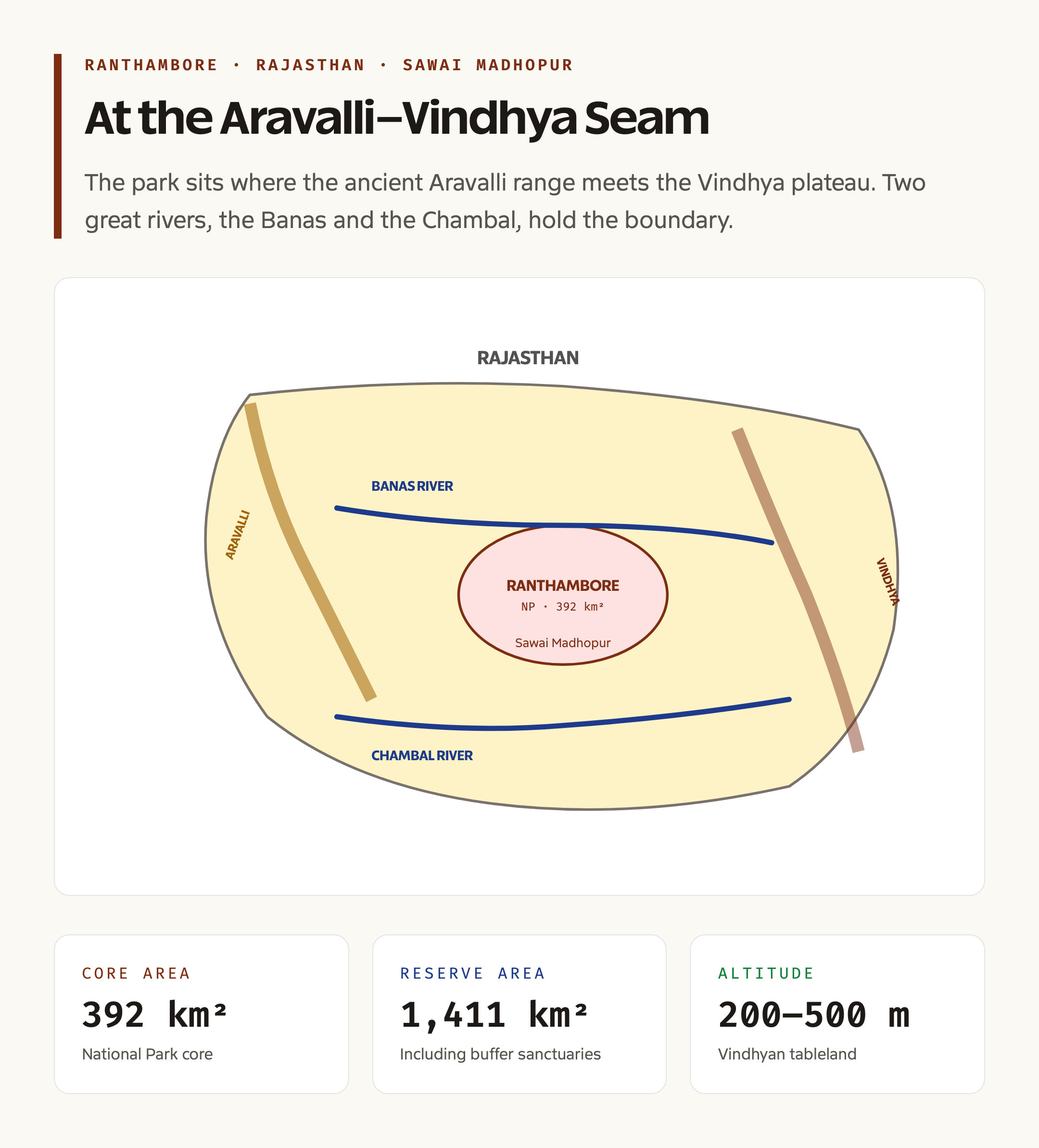
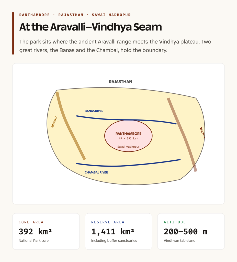
Ranthambore lies at 26.0 degrees North, 76.5 degrees East, in Sawai Madhopur district of Rajasthan. The total Tiger Reserve area is 1,411 square kilometres, of which the National Park core is 392 square kilometres. The terrain is undulating Vindhyan tableland with steep ridges, plateau tops, narrow valleys, and several seasonal streams. The Banas River bounds the park to the north and the Chambal River to the south, and the famous tank-and-fort complex sits at the heart of the park.
The park was declared a Sawai Madhopur Game Sanctuary in 1955, included in Project Tiger in 1973, notified as a National Park in 1980, and renamed Ranthambore National Park. The Ranthambore Fort, which sits on a 700-foot escarpment within the park, was inscribed as a UNESCO World Heritage Site in 2013 as part of the Hill Forts of Rajasthan group. Key species include the Royal Bengal Tiger, the Indian leopard, the sloth bear, the striped hyena, the sambar deer, the chital, the marsh crocodile, and over 270 bird species.
What Ranthambore Is
Ranthambore is the eastern fringe of the Aravalli range and the western edge of the Vindhya plateau, fused into a single landscape of low ridges and broad valleys covered in tropical dry deciduous forest. The dominant tree is the dhok, Anogeissus pendula, which forms an open canopy over a mosaic of grass, scrub, and rocky outcrop. The forest is among the driest tiger habitat in India and has the lowest prey density of any major tiger reserve, which makes the persistence of a high-density tiger population at Ranthambore an unusual ecological achievement.
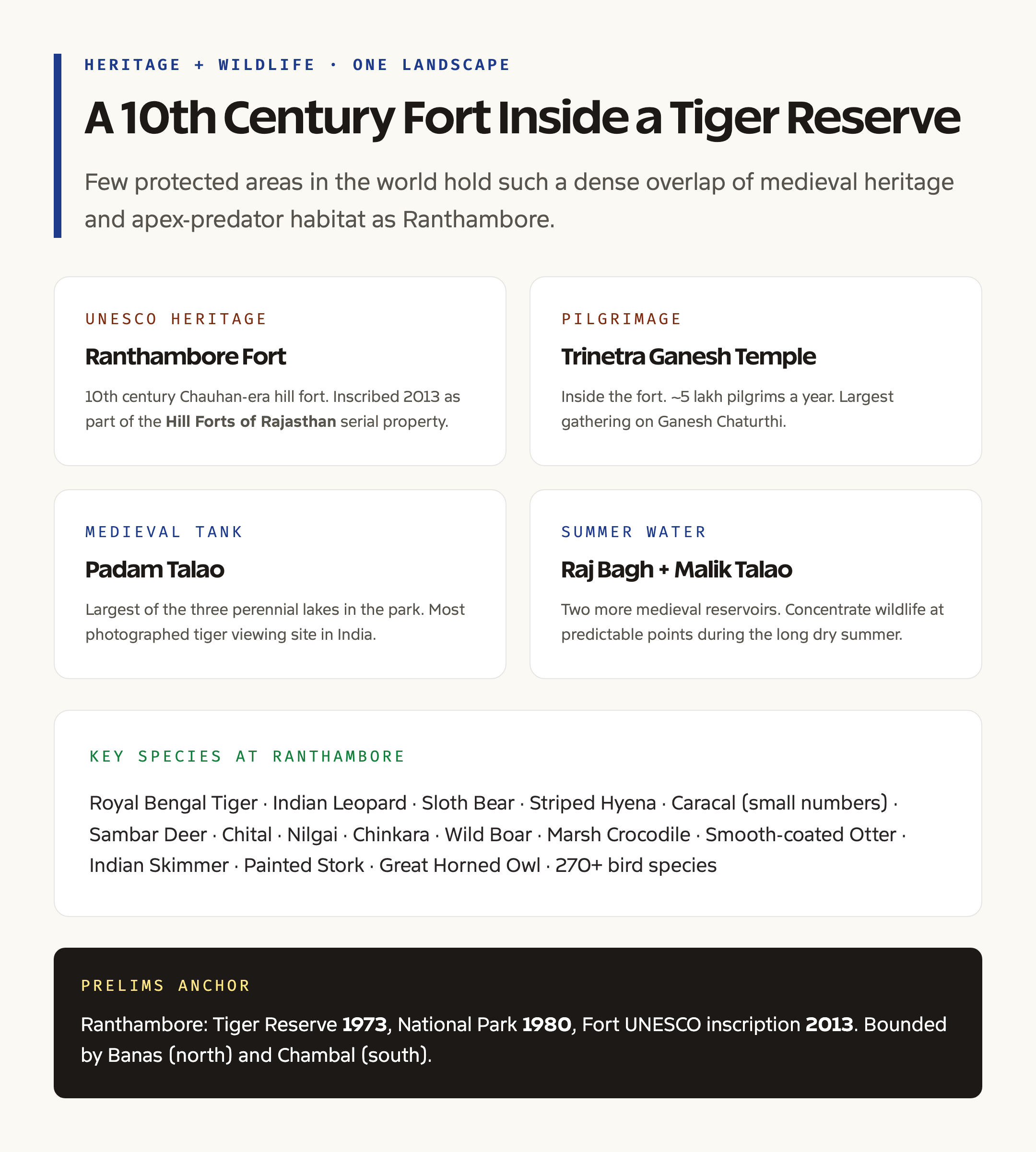
The park’s landscape is also strongly anthropogenic. The Ranthambore Fort dates to the 10th century and was a major Chauhan stronghold during the medieval period. The fort complex includes the Trinetra Ganesh Temple, one of the most visited Ganesh shrines in north India, with regular pilgrim traffic that runs straight through tiger habitat. Three large lakes inside the park, Padam Talao, Raj Bagh Talao, and Malik Talao, are medieval irrigation reservoirs built by the Chauhan and later Mughal regimes. They now serve as the most reliable summer water sources for the park’s wildlife and the most photographed tiger viewing locations in India.
Background and Historical Context
The Ranthambore landscape has been managed by humans for at least a thousand years. The Chauhan rulers built the fort, the lakes, the temples, and the irrigation works. The Mughal emperors, especially Akbar, used the area as a hunting reserve. The Maharajas of Jaipur, who took over from the late 17th century, formalised the area as a royal shooting ground, and that designation, ironically, kept large parts of the forest intact through the colonial era when other dry-zone forests were felled for cropland and railways.
After independence, the area passed to the Rajasthan Forest Department. It was declared the Sawai Madhopur Game Sanctuary in 1955, but actual hunting controls were weak and tiger numbers fell into the 1960s. The 1972 Wildlife Protection Act and the 1973 launch of Project Tiger transformed the area’s trajectory. Ranthambore was one of the first nine reserves notified, alongside Corbett, Kanha, Manas, Melghat, Bandipur, Palamau, Simlipal, and Sundarbans. The park was carved out as a 392 square kilometre core in 1980, and the famous tiger numbers began their slow recovery through the 1980s and 1990s, peaking in the early 2000s before a poaching crisis in 2004-05 cut the population almost in half. The post-2005 recovery is the basis for the present management regime and has been documented in detail in the State of the Tigers reports.
Key Provisions and Park Governance
Ranthambore is managed under the four-tier framework that governs every Indian tiger reserve. The first tier is the National Park itself, the 392 square kilometre inviolate core where no human activity other than research, monitoring, and tightly controlled tourism is permitted. The second tier is the surrounding sanctuaries, Kailadevi and Sawai Mansingh, which form a buffer zone with regulated grazing, fuelwood collection, and tourism. The third tier is the eco-sensitive zone, an outer ring up to 10 kilometres from the boundary where industrial activity is restricted. The fourth tier is the larger landscape, which includes corridors connecting Ranthambore to Mukundra Hills Tiger Reserve and to the Chambal Valley.
Statutory authority sits with the National Tiger Conservation Authority and the Rajasthan State Forest Department. The Field Director of Ranthambore reports to the Chief Wildlife Warden of Rajasthan and through him to the NTCA, which sets all-India norms for tiger reserve management, monitoring, and reporting. Annual budgetary support comes from a 60:40 centre-state share under Project Tiger. For the broader policy architecture, read the parent guide on tiger reserves in India and the layered framework in environmental laws in India.
Why Ranthambore Matters
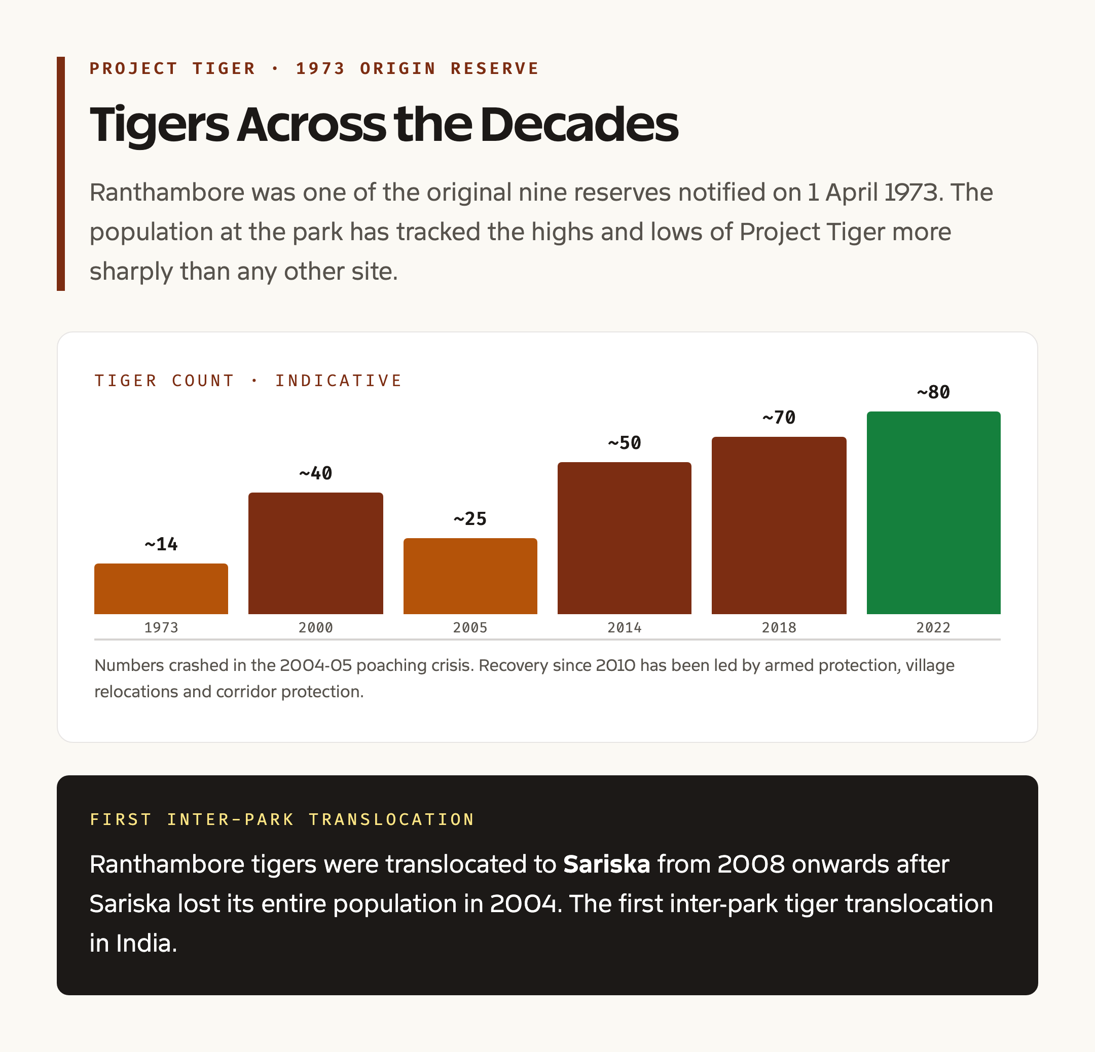
Ranthambore matters first as a working laboratory for tiger conservation in dry forest. Almost every Indian tiger reserve outside the wet evergreen south sits in some variant of dry deciduous forest, and the techniques developed at Ranthambore for low-prey, high-tourism, high-conflict conditions have been transplanted to Sariska, Mukundra, Panna, and several Madhya Pradesh reserves. The 2008 to 2010 reintroduction of tigers from Ranthambore into Sariska, after Sariska lost its entire tiger population in 2004, was the first inter-park tiger translocation in India and is now standard practice.
It matters second as an integrated heritage and biodiversity site. The Ranthambore Fort UNESCO inscription, the Trinetra Ganesh Temple pilgrimage, the medieval lakes, and the tiger habitat exist in a single 1,411 square kilometre footprint. Few parks in India carry such a dense overlap of ecological and cultural value, and the management has had to develop a hybrid model that protects wildlife without barring traditional access to the temple and the fort.
It matters third as a case study in tourism economics. Ranthambore receives roughly 4 lakh visitors a year, of whom a quarter come on tiger safaris. The associated economy of guides, drivers, lodges, and craft sales sustains around 30,000 jobs in Sawai Madhopur and adjoining districts. The park is among the highest-revenue protected areas in India and offers a working example of how wildlife tourism can be aligned with conservation rather than working against it.
Detailed Analysis: Geography and Hydrology
The park sits at the eastern terminus of the Aravalli range, where the ancient fold mountains finally dip below the Vindhyan tableland. Average elevation is between 200 and 500 metres, with the highest point at the Ranthambore Fort plateau at around 480 metres. Soils are shallow, stony, and red, derived from Vindhyan sandstone and quartzite. The forest type is classified as 5A/C1b, northern tropical dry deciduous, in the Champion and Seth scheme.
Hydrology defines the ecology. The Banas River, the largest tributary of the Chambal entirely within Rajasthan, flows along the northern edge of the park. The Chambal River, the cleanest large river in the Indian plains, flows along the southern edge. Within the park, three perennial lakes, Padam Talao, Raj Bagh Talao, and Malik Talao, plus several seasonal streams, ensure year-round water availability and concentrate wildlife at predictable points during the long dry summer. The Banas and Chambal corridors also connect Ranthambore to other protected areas in Rajasthan and Madhya Pradesh, making the park a crucial node in the central Indian tiger landscape. For the parent context on India’s river systems, read the guide on river systems of India.
Flora and Fauna
The flora is dry deciduous and dhok-dominant, with associated trees including babul, ber, banyan, peepal, mahua, jamun, kadam, and tamarind. The grass cover, mostly Heteropogon and Themeda species, supports the prey base. Bamboo is patchy, mostly along stream banks. Aquatic plants in the lakes include lotus, water lily, and various reeds.
Fauna includes the Royal Bengal Tiger, with around 80 individuals in the latest count. Other carnivores include the Indian leopard, the striped hyena, the sloth bear, the jungle cat, the caracal in small numbers, and the Indian fox. Ungulate prey includes the sambar deer, the chital, the nilgai, the chinkara, and wild boar. Smaller mammals include the rhesus macaque, the Hanuman langur, the Indian flying fox, the porcupine, and the Indian hare. The marsh crocodile holds the lakes and rivers, alongside the smooth-coated otter and the gharial in the Chambal. Bird life is rich, with over 270 species recorded, including the crested serpent eagle, the painted stork, the Indian skimmer, the great horned owl, and the rufous-treepie. The park is a notified Important Bird Area.
Tribes, Culture, and Surrounding Communities
The Sawai Madhopur landscape is home to two main traditional communities. The Meenas, an ancient agro-pastoral group historically associated with the Ranthambore Fort and the broader region, form the largest population in villages around the park. The Gujjars, a buffalo-herding pastoralist community, inhabit the buffer-zone villages and have a long association with the dhok forests as a grazing resource.
Both communities have negotiated complex relationships with the park since 1973. Eight villages were relocated from the core between 1976 and 2010 under a programme that has had its share of controversy and that informed later relocation guidelines under the National Tiger Conservation Authority. The Trinetra Ganesh Temple inside the fort draws roughly half a million pilgrims a year, with the largest gathering on Ganesh Chaturthi. The pilgrimage has been negotiated into the park’s tourism schedule rather than barred, and the route is one of the few protected-area corridors in India where pilgrim traffic and tiger habitat directly overlap.
Ranthambore in the Project Tiger Story
Ranthambore was one of the original nine Project Tiger reserves of 1973 and has been a barometer of the programme’s health ever since. The first decade saw rapid recovery. The 1980s consolidated the reserve and brought the first wave of Indian and international wildlife tourism. The 1990s peaked the population. The 2004-05 poaching crisis, which exposed the gap between paper protection and field-level enforcement, became a turning point in Project Tiger governance. The post-2005 reforms, which included armed Special Tiger Protection Force units, intelligence-led anti-poaching, and the all-India tiger estimation under the NTCA, all drew lessons from the Ranthambore experience. For the broader story, read the Project Tiger conservation guide.
Connections With Related UPSC Topics
Ranthambore links naturally to several other UPSC themes. It links to Kaziranga National Park as a parallel case of single-flagship conservation in a different biome. It links to the State of India Environment 2026 report where the latest figures on tiger numbers and reserve performance are tabulated. It links to biodiversity in India as a key node of the central Indian tiger landscape. And it links to tiger reserves in India as one of the original nine and a continuing benchmark.
For prelims, anchor four facts. First, Ranthambore is in Sawai Madhopur district, Rajasthan, at the Aravalli-Vindhya junction. Second, it became a Tiger Reserve in 1973 and a National Park in 1980. Third, the Ranthambore Fort is a UNESCO World Heritage Site since 2013 as part of the Hill Forts of Rajasthan. Fourth, the park is bounded by the Banas River to the north and the Chambal River to the south, and the three principal water bodies inside are Padam Talao, Raj Bagh Talao, and Malik Talao.
Frequently Asked Questions
Where is Ranthambore National Park located?
Ranthambore National Park is in Sawai Madhopur district of eastern Rajasthan, between the Aravalli range to the west and the Vindhya plateau to the east. The nearest railhead is Sawai Madhopur, on the Delhi-Mumbai broad-gauge line, and the nearest airport is Jaipur, around 180 kilometres away.
When was Ranthambore declared a Tiger Reserve and a National Park?
Ranthambore was one of the nine original Project Tiger reserves notified on 1 April 1973. It was upgraded to a National Park in 1980. The total Tiger Reserve area, including the Kailadevi and Sawai Mansingh sanctuaries, is 1,411 square kilometres. The National Park core is 392 square kilometres.
Why is the Ranthambore Fort important?
The Ranthambore Fort is a 10th century Chauhan-era hill fort inscribed by UNESCO as a World Heritage Site in 2013, as part of the Hill Forts of Rajasthan group. The fort hosts the Trinetra Ganesh Temple, one of the most visited Ganesh shrines in north India. The fort sits inside the National Park, which makes Ranthambore a unique heritage and biodiversity site.
Which rivers flow around Ranthambore?
The park is bounded by two important rivers. The Banas River, the largest tributary of the Chambal entirely within Rajasthan, flows along the northern boundary. The Chambal River, the cleanest large river in the Indian plains, flows along the southern boundary. Both rivers also serve as ecological corridors connecting Ranthambore to other protected areas in Rajasthan and Madhya Pradesh.
Which key species live in Ranthambore?
The flagship species is the Royal Bengal Tiger, with around 80 individuals in the latest count. Other notable species include the Indian leopard, the sloth bear, the striped hyena, the sambar deer, the chital, the nilgai, the chinkara, the marsh crocodile in the lakes and the gharial in the Chambal, and over 270 bird species including the painted stork, the Indian skimmer, and the great horned owl.
Who are the main tribal communities around Ranthambore?
The two main traditional communities in the Ranthambore landscape are the Meenas, an ancient agro-pastoral group long associated with the Ranthambore Fort and the broader region, and the Gujjars, a buffalo-herding pastoralist community in the buffer villages with a historical relationship to the dhok forests as a grazing resource.
Tell Google you want more of this.
Add Anantam IAS as a preferred sourceOne tap, and this site shows up more often in your own Top Stories, AI Overviews and AI Mode. Remove it any time.