

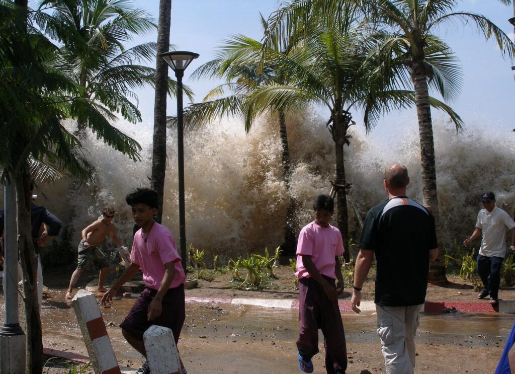
A tsunami is a series of very long ocean waves generated by the sudden vertical displacement of a large volume of water. Understanding tsunami causes and formation is critical because India faces threat from the Andaman–Sumatra subduction front and the Makran trench off Pakistan, and over 84 lakh Indians live in tsunami-vulnerable coastal stretches across Tamil Nadu, Andhra Pradesh, Kerala, Odisha and the islands. For UPSC GS-I (geomorphology, oceanography) and GS-III (disaster management), the topic of tsunami causes and formation sits at the intersection of plate tectonics, marine geophysics and the institutional response architecture led by INCOIS and NDMA.
The word tsunami is Japanese for “harbour wave,” coined by fishermen who returned to find their ports devastated while they had felt nothing in deep water. The term entered global usage after the 2004 Indian Ocean disaster.
How a Tsunami Forms: The Basic Physics
A tsunami requires three conditions:
- A trigger that vertically displaces a large column of seawater.
- Deep water at the source so the displacement transmits efficiently.
- A shoaling coast to amplify the wave near land.
When the seafloor jolts up or down, the entire water column above it is lifted or dropped. Gravity then pulls the disturbed surface back, generating long-wavelength waves that race outward across the ocean basin.
Why tsunamis are unlike normal sea waves
Ordinary wind waves have wavelengths of 100–200 metres and travel at 10–20 km/h. A tsunami has a wavelength of 100–500 km, a period of 10 minutes to two hours, and travels at the speed of a jet aircraft — about 800 km/h in 4,000 m of water (speed ≈ √(g × depth)). In the open ocean its amplitude is often less than a metre and ships barely notice it. As it enters shallow water near the coast, wave speed drops, wavelength shortens, and water piles up — amplitudes can grow to 10–30 m and the wave breaks as a wall of water or a fast-rising surge.
Causes of Tsunamis
Several mechanisms can trigger a tsunami; submarine earthquakes account for about 80% of recorded events.
Submarine earthquakes
The dominant cause. Vertical seafloor displacement during a large subduction-zone earthquake (typically M > 7.5, shallow focus, thrust mechanism) lifts the overlying water and seeds the tsunami.
- The 2004 Indian Ocean tsunami was generated by the M 9.1–9.3 Sumatra–Andaman earthquake on the Sunda megathrust. Read the full event analysis in our Indian Ocean tsunami 2004 explainer.
- The 2011 Tohoku tsunami in Japan followed the M 9.1 megathrust event, killing ~18,500 people and triggering the Fukushima Daiichi nuclear accident.
- The 1960 Valdivia (Chile) M 9.5 — the largest instrumentally recorded earthquake — caused a Pacific-wide tsunami that struck Hawaii and Japan.
- The 1755 Lisbon earthquake generated a transatlantic tsunami that reached the Caribbean.
The link between megathrust events and tsunamis is best understood alongside the plate tectonics theory and our note on earthquake causes and types.
Submarine and coastal landslides
A large mass of sediment or rock sliding into the sea displaces water suddenly.
- The 1958 Lituya Bay, Alaska event saw a rock-fall trigger a wave that ran up 524 m on the opposite shore — the highest recorded wave runup.
- The 1998 Papua New Guinea tsunami (over 2,200 deaths) was generated by an offshore slump triggered by a moderate earthquake.
- Storegga slides off Norway, about 8,200 years ago, generated tsunamis that reached Scotland and the Shetland Islands.
Landslide-tsunamis often produce locally devastating but regionally limited waves.
Volcanic eruptions
Explosive volcanic activity, caldera collapse, pyroclastic flows entering the sea, or flank failures can all generate tsunamis.
- Krakatoa, 1883 — the eruption and caldera collapse produced 30–40 m waves that killed at least 36,000 people in the Sunda Strait. The volcano lies on the Ring of Fire.
- Anak Krakatau, 2018 — a flank collapse during eruption caused a tsunami with no seismic warning, killing 437.
- Hunga Tonga–Hunga Haʻapai, 2022 — an underwater volcanic explosion sent atmospheric and ocean waves around the world; the meteo-tsunami was felt as far as Peru.
Meteorite impacts
Rare but possible. The Chicxulub asteroid impact 66 million years ago produced a megatsunami over a kilometre high. Models suggest even a 200 m asteroid striking a deep ocean would generate basin-wide tsunamis. While not a current operational hazard, it is referenced in geological history.
Meteorological tsunamis (meteotsunamis)
Atmospheric pressure jumps from squall lines or storms can resonate with a continental shelf and produce wave heights up to 6 m, as in the Mediterranean rissaga and Great Lakes events. They are not true tsunamis but often classified with them.
Anatomy of a Tsunami Event
A typical tsunami unfolds in identifiable stages:
- Generation: vertical seafloor or coastal displacement.
- Propagation: long waves travel across the ocean at hundreds of km/h with low amplitude.
- Inundation: shoaling amplifies the wave; the leading trough often causes the sea to recede dramatically, exposing the seabed — a critical natural warning sign.
- Runup: the maximum vertical height water reaches on land above mean sea level.
- Drawdown: water rushes back to sea, often carrying debris and people.
Several waves usually arrive over hours; the first is rarely the largest. The 2004 event saw the third wave being the deadliest in many places.
Case Study: 2004 Indian Ocean Tsunami
On 26 December 2004 at 00:58 UTC, a 1,300 km rupture along the Sunda megathrust offshore northern Sumatra generated the deadliest tsunami in recorded history.
- Magnitude: M 9.1–9.3.
- Deaths: about 227,898 across 14 countries.
- Worst hit: Indonesia (Banda Aceh), Sri Lanka, India (Tamil Nadu, Andhra Pradesh, Kerala, Andaman & Nicobar), Thailand, Maldives, Somalia.
- Run-up exceeded 30 m in Aceh; 15 m in parts of Andaman.
In India, ~12,400 lives were lost (including missing). The disaster exposed the absence of a Pacific-style tsunami warning system in the Indian Ocean and led to the creation of the Indian Tsunami Early Warning Centre (ITEWC) at INCOIS.
Case Study: Tohoku 2011
On 11 March 2011, an M 9.1 megathrust earthquake off Honshu generated a tsunami with waves up to 40.5 m at Miyako. The tsunami overtopped the Fukushima Daiichi seawall (designed for 5.7 m), causing loss of coolant and three reactor meltdowns. The event reset global thinking on nuclear safety, tsunami modelling and coastal seawall design.
India’s Tsunami Hazard
- Andaman–Sumatra subduction zone to the east of the Andaman & Nicobar Islands is the most active source; the islands receive a wave in 15–30 minutes, the mainland in about 2–3 hours.
- Makran subduction zone off Pakistan–Iran is the western source; a Makran tsunami in 1945 (M 8.1) killed about 4,000 along the coasts of Pakistan, Iran and Oman, with waves reaching Gujarat.
- Indian coast has 84 lakh tsunami-vulnerable people. Tamil Nadu’s Nagapattinam, Cuddalore, Kanyakumari; Andhra Pradesh’s Prakasam; Odisha’s Jagatsinghpur and Kendrapara; and Kerala’s Kollam–Alappuzha stretch are key.
INCOIS and the Indian Tsunami Early Warning Centre
The Indian National Centre for Ocean Information Services (INCOIS), Hyderabad — under the Ministry of Earth Sciences — operates the ITEWC since October 2007.
Key components
- 17 broadband seismic stations and access to global seismic networks for fast magnitude estimation.
- 4 bottom-pressure recorders (BPRs) and access to over 25 DART-type buoys in the Indian Ocean and Bay of Bengal.
- 36 coastal tide gauges along Indian and Indian Ocean coasts.
- Tsunami modelling using the TUNAMI-N2 code with a pre-computed scenario database for 1,800 possible events.
- Bulletin dissemination through SMS, e-mail, fax, GTS, and the Common Alerting Protocol (CAP) integrated with the NDMA SACHET platform.
Bulletin levels
- Warning: high inundation expected within 60 minutes.
- Alert: moderate impact possible.
- Watch: source confirmed, modelling under way.
ITEWC also acts as a Tsunami Service Provider (TSP) for the UNESCO–IOC Indian Ocean Tsunami Warning System (IOTWMS), serving 28 nations along with Australia and Indonesia.
Coastal Mitigation Measures
- Bioshields: mangroves, casuarina, and beach vegetation reduce wave energy. The Pichavaram mangroves shielded villages during 2004.
- Coastal Regulation Zone (CRZ) restrictions on construction within 200 m of the high tide line.
- Vertical evacuation structures in islands and Tamil Nadu fishing villages.
- Multi-hazard early warning sirens along the coast, integrated with INCOIS bulletins.
- Community drills under the IOWave exercise series.
The NDMA’s National Disaster Management Guidelines on Tsunamis (2010) framework guides all these measures.
Frequently Asked Questions
What is a tsunami and how is it formed?
A tsunami is a series of long ocean waves caused by the sudden vertical displacement of a large volume of water, usually by a submarine earthquake, underwater landslide, volcanic eruption or rare meteorite impact. The disturbance propagates as long-wavelength waves that amplify as they reach shallow coasts.
What causes most tsunamis?
About 80% of tsunamis are caused by large, shallow-focus submarine earthquakes — typically magnitude 7.5 and above — along subduction zones such as the Sunda, Japan and Cascadia trenches.
How fast does a tsunami travel?
In the open ocean, where depth is around 4,000 m, a tsunami travels at about 800 km/h — comparable to a passenger jet. As it nears the coast and the water shallows, the speed drops sharply but the wave height grows.
Why is the first wave often not the biggest?
A tsunami is a wave train of several pulses arriving over minutes to hours. The third or fourth wave was the deadliest in many places during the 2004 event, because reflections from offshore topography and the geometry of the source combine constructively.
What was the 2004 Indian Ocean tsunami?
The 2004 Indian Ocean tsunami was triggered by the M 9.1–9.3 Sumatra–Andaman earthquake on 26 December 2004 and killed about 227,898 people in 14 countries, including over 12,000 in India.
What is INCOIS and how does it warn India?
INCOIS — the Indian National Centre for Ocean Information Services in Hyderabad — runs the Indian Tsunami Early Warning Centre. It analyses seismic data, bottom-pressure recorders and tide gauges, runs pre-computed tsunami scenarios, and issues bulletins within minutes through SMS, CAP and the NDMA SACHET platform.
Which Indian coasts are most vulnerable to tsunamis?
The eastern coast facing the Andaman–Sumatra subduction front — Andaman & Nicobar, Tamil Nadu, Andhra Pradesh, Odisha, the southern Kerala coast, and West Bengal’s Sundarbans — is most exposed. Gujarat and the Konkan are exposed to Makran-sourced events.
Can volcanoes cause tsunamis?
Yes. Caldera collapse (Krakatoa 1883), flank failures (Anak Krakatau 2018) and powerful underwater eruptions (Hunga Tonga 2022) have all produced lethal tsunamis, especially when the volcano lies near the Ring of Fire.
Tell Google you want more of this.
Add Anantam IAS as a preferred sourceOne tap, and this site shows up more often in your own Top Stories, AI Overviews and AI Mode. Remove it any time.






