

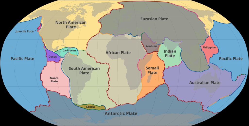
The plate tectonics theory is the grand unifying framework of modern earth science. It explains why continents move, why mountains rise, why earthquakes shake specific belts, and why volcanoes cluster along narrow lines on the globe. Born in the 1960s from the older ideas of continental drift and seafloor spreading, the plate tectonics theory treats Earth’s rigid outer shell — the lithosphere — as a mosaic of large and small plates that float on the plastic asthenosphere and drift a few centimetres a year. For a UPSC aspirant, this theory is the gateway to physical geography, hazard studies and even palaeoclimate.
Origin: From Continental Drift to Plate Tectonics
The journey began with Alfred Wegener, a German meteorologist who proposed the continental drift hypothesis in 1912 and elaborated it in his 1915 book The Origin of Continents and Oceans. Wegener suggested that all landmasses were once joined in a supercontinent he called Pangaea, surrounded by a single ocean Panthalassa, which began to break up about 200 million years ago.
Wegener’s evidence
- Jigsaw fit of continents, especially the bulge of Brazil into the Gulf of Guinea.
- Fossil correlation: Mesosaurus found in Brazil and South Africa, Glossopteris flora across India, Australia, Antarctica, Africa and South America.
- Rock and structural match between the Appalachian and Caledonian mountains, and between the Karoo (South Africa) and Santa Catarina (Brazil) sequences.
- Palaeoclimatic evidence: glacial striations of Permo-Carboniferous age in tropical India, Australia and Brazil, and coal seams in Antarctica.
Wegener’s mechanism — tidal forces and centrifugal pull — was weak, and contemporary geophysicists rejected drift for half a century.
Holmes and convection currents
In 1928–29 the British geologist Arthur Holmes proposed that mantle convection currents driven by radiogenic heat could carry continents. His diagram of rising currents under mid-ocean ridges and descending currents under trenches became the missing engine for drift.
Harry Hess and Seafloor Spreading
After the Second World War, marine geophysics revealed mid-ocean ridges, deep oceanic trenches, and remarkably young ocean floors. Harry Hess, in his 1962 paper History of Ocean Basins, gave the world seafloor spreading.
- Hot mantle material rises at mid-ocean ridges, cools, and adds new basaltic crust on either side.
- The seafloor moves outward symmetrically like two conveyor belts.
- Old oceanic crust is destroyed at deep trenches through subduction.
- This explains why no ocean floor is older than about 180 million years, while continents preserve rocks up to 4 billion years old.
The palaeomagnetic confirmation
Vine, Matthews and Morley (1963) matched Hess’s idea with the magnetic stripes discovered on the ocean floor. As basalt cools at a ridge, iron-bearing minerals lock in Earth’s current magnetic polarity. Because the geomagnetic field reverses periodically, the spreading seafloor records alternating bands of normal and reversed magnetism, parallel and symmetric on both sides of the ridge — an undeniable fingerprint of spreading.
The Birth of Plate Tectonics in the 1960s
By the late 1960s the data — magnetic stripes, deep-focus earthquakes along Wadati–Benioff zones, transform faults, hotspot tracks — needed one theory. Three geophysicists provided it:
- John Tuzo Wilson (Canadian) coined the term plate, identified transform faults, and proposed the Wilson cycle of opening and closing oceans.
- Dan McKenzie (British, with Robert Parker) gave the mathematical proof in 1967 by treating plates as rigid spherical caps moving on Euler poles.
- Jason Morgan (American) independently formalised the rigid-plate model and introduced hotspots and mantle plumes.
By 1968 the plate tectonics theory was the consensus paradigm of earth science.
The Lithospheric Plates
Earth’s outer rigid shell — the lithosphere — is about 100 km thick under oceans and 150–250 km thick under continents. It is broken into plates that ride on the ductile asthenosphere beneath.
Seven major plates
- Pacific Plate — largest, almost entirely oceanic.
- North American Plate — includes North America, Greenland, and part of Siberia.
- South American Plate.
- Eurasian Plate — Europe, most of Asia, and part of the Atlantic floor.
- African Plate — Africa and surrounding ocean floor.
- Indo-Australian Plate — sometimes split into Indian and Australian sub-plates.
- Antarctic Plate — Antarctica and the encircling Southern Ocean floor.
Minor plates
These include the Nazca, Cocos, Caribbean, Arabian, Philippine, Juan de Fuca, Scotia, Iranian, Burmese and Caroline plates. Microplates such as the Sunda and Yangtze are also recognised. India is part of the Indo-Australian Plate and is moving north-north-east at about 5 cm/year, pushing into Eurasia and uplifting the Himalayas.
Types of Plate Boundaries
The plate tectonics theory classifies plate margins into three principal types, each producing characteristic landforms and hazards.
Divergent (constructive) boundaries
- Plates move apart; magma rises to form new crust.
- Oceanic example: Mid-Atlantic Ridge, separating the Eurasian and North American plates; spreading rate about 2.5 cm/year.
- Continental example: East African Rift — Africa is being torn into the Nubian and Somali plates, with the Red Sea and Gulf of Aden marking advanced rifting.
- Landforms: mid-ocean ridges, rift valleys, fissure volcanoes (Iceland), shallow earthquakes.
Convergent (destructive) boundaries
Where plates collide. The denser plate dives beneath the lighter one in a process called subduction.
- Oceanic–continental: the Nazca Plate subducts beneath the South American Plate, producing the Andes and the Peru–Chile trench.
- Oceanic–oceanic: the Pacific Plate subducts under the Philippine Plate, forming the Mariana Trench (deepest point on Earth) and the Mariana arc of volcanoes.
- Continental–continental: neither plate sinks. The Indo-Australian and Eurasian plates have been colliding for ~50 million years, building the Himalayas and the Tibetan Plateau. No volcanoes form here, but earthquakes are frequent.
Convergent margins generate the world’s deep-focus earthquakes along Wadati–Benioff zones, the most violent volcanoes (Mt St Helens, Krakatoa) and tsunamis that devastate coastlines — as seen in the 2004 Indian Ocean tsunami, which originated at the Sunda subduction trench.
Transform (conservative) boundaries
- Plates slide horizontally past each other; crust is neither created nor destroyed.
- Classic example: the San Andreas Fault in California, where the Pacific Plate moves north-west past the North American Plate.
- The North Anatolian Fault in Turkey and the Alpine Fault in New Zealand are similar.
- These boundaries produce shallow but powerful earthquakes. To understand the seismic side of these movements in detail, see our note on earthquake causes and types.
Driving Forces of Plate Motion
Modern research recognises a combination of forces, not a single conveyor belt.
- Ridge push: gravity slides plates down the elevated mid-ocean ridges.
- Slab pull: the sinking, cold, dense slab in a subduction zone pulls the rest of the plate behind it. This is now considered the strongest driver.
- Mantle drag: friction from convecting asthenosphere.
- Trench suction and basal traction add minor contributions.
Heat from the decay of radioactive isotopes (uranium-238, thorium-232, potassium-40) and residual primordial heat keep the mantle convecting.
Evidence Supporting Plate Tectonics
The plate tectonics theory is supported by multiple independent lines of evidence:
- Palaeomagnetism: rocks of the same age in India and Australia record magnetic poles in different positions, showing the continents have drifted.
- Symmetric magnetic stripes on either side of mid-ocean ridges.
- Fossil and floral matches across now-separated continents (Wegener’s original data).
- Distribution of earthquakes along narrow belts — circum-Pacific, mid-Atlantic, Alpine–Himalayan — mapping plate margins.
- Volcanic belts coinciding with subduction zones and ridges, especially around the Ring of Fire.
- GPS geodesy: satellite measurements directly observe plates moving 1–15 cm per year. India is converging with Eurasia at about 5 cm/year, the Pacific–Nazca boundary spreads at over 15 cm/year.
- Hotspot trails like the Hawaii–Emperor seamount chain trace plate motion over fixed mantle plumes.
Plate Tectonics and the Indian Subcontinent
Around 180 million years ago, India broke from Gondwanaland, drifted northward at speeds reaching 18–20 cm/year, crossed the Tethys Ocean and collided with Eurasia ~50 million years ago. The collision is still active, uplifting the Himalayas by about 5 mm/year and producing intense seismicity from Kashmir to Arunachal. This geodynamic story is the foundation for understanding India’s relief, drainage, and earthquake-tsunami risk on its Andaman–Sumatra frontier.
Significance and Limitations
The plate tectonics theory unified geology, geophysics, palaeontology and climatology. It explains:
- Distribution of continents, oceans, mountain belts.
- Location of earthquakes, volcanoes and tsunami source zones.
- Mineral and hydrocarbon provinces.
- Long-term climate change through ocean–atmosphere reconfiguration.
Yet some questions remain — intra-plate earthquakes (Latur 1993, Koyna 1967, Bhuj 2001), mantle plume dynamics, and the precise initiation of plate tectonics on early Earth. These open frontiers keep the theory alive and evolving.
Frequently Asked Questions
Who proposed the plate tectonics theory?
The modern plate tectonics theory was formulated in the 1960s by John Tuzo Wilson, Dan McKenzie, Robert Parker and Jason Morgan, building on Alfred Wegener’s continental drift (1912) and Harry Hess’s seafloor spreading (1962).
What is the difference between continental drift and plate tectonics?
Continental drift, proposed by Wegener, said continents move through the ocean floor but offered no convincing mechanism. Plate tectonics says the entire lithosphere — continents plus ocean floor — moves as rigid plates driven mainly by slab pull and ridge push.
How many major plates are there on Earth?
There are seven major plates: Pacific, North American, South American, Eurasian, African, Indo-Australian and Antarctic. Several minor plates such as Nazca, Cocos, Arabian and Philippine, and many microplates, are also recognised.
What are the three types of plate boundaries?
The three principal types are divergent (plates move apart, new crust forms), convergent (plates collide, one subducts), and transform (plates slide past each other horizontally).
What evidence proves plate tectonics?
Key evidence includes matching coastlines and fossils across continents, symmetric magnetic stripes on the ocean floor, the global pattern of earthquakes and volcanoes along plate margins, GPS measurements of plate motion, and hotspot trails like Hawaii.
Which Indian plate is moving and at what speed?
India is part of the Indo-Australian Plate, moving north-north-east at about 5 cm per year, continuously colliding with the Eurasian Plate and uplifting the Himalayas.
What is the Ring of Fire and how is it linked to plate tectonics?
The Ring of Fire is a horseshoe belt around the Pacific Ocean where roughly 75% of the world’s volcanoes and 90% of earthquakes occur, marking subduction and transform boundaries of the Pacific Plate with its neighbours.
Why is the plate tectonics theory important for UPSC?
It is the foundation of physical geography (mountains, oceans, earthquakes, volcanoes), disaster management (seismic and tsunami zones) and current affairs on hazards. GS-I and GS-III repeatedly draw on it.
Tell Google you want more of this.
Add Anantam IAS as a preferred sourceOne tap, and this site shows up more often in your own Top Stories, AI Overviews and AI Mode. Remove it any time.






