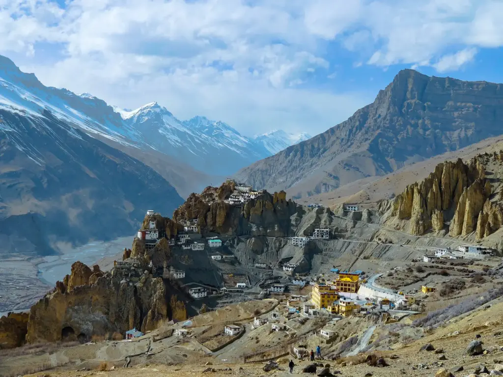
Photographs sell Spiti as a stark, beautiful blank, brown mountains, a turquoise river, a whitewashed monastery on a spur, and most people file it away as a hard-to-reach travel destination and nothing more. That framing misses what makes Spiti genuinely important. It is one of the very few cold deserts in India, a high, rain-starved trough where the Himalaya, a great river system, a thousand-year-old Buddhist civilisation, and the snow leopard all meet in one thin strip of habitable land. Understand Spiti properly and you are actually holding four topics at once, physical geography, river systems, culture, and conservation, wired together by altitude. Here is the valley, built up the way the land itself is.
Where Spiti is and why it is a cold desert
Spiti is a high-altitude valley in the Lahaul and Spiti district of Himachal Pradesh, tucked into the far north-east of the state against the border with Tibet. The name Spiti is usually translated as “the Middle Land,” because the valley sits between India and Tibet, and that in-between quality is the key to everything about it: its climate, its faith, and its people all read as a bridge between the Indian and Tibetan worlds.
The single fact that explains the landscape is that Spiti is a cold desert, and the reason is the rain shadow. The Great Himalayan range rises to the south and west of the valley and wrings the monsoon dry before it can climb over, so the clouds that soak Kullu and Manali arrive at Spiti with almost nothing left. The result is a place that gets very little rain yet is bitterly cold, buried in snow for months and cut off from the rest of the country through winter. A cold desert is defined not by heat but by aridity plus extreme cold, and Spiti is the textbook Indian example alongside Ladakh: barren, treeless slopes, a thin ribbon of green only where the river waters the valley floor, and a sky so clear it has made the region a destination for stargazers.
Geographically Spiti belongs to the Trans-Himalaya, the belt of ranges lying north of the Great Himalaya and merging into the Tibetan Plateau. This is why the valley feels Tibetan rather than Indian in its bones: physically it is on the plateau’s edge, part of the same cold, high, wind-scoured world. Elevations run from around 3,000 metres on the valley floor to peaks well above 6,000 metres, and the main town of Kaza sits at roughly 3,650 metres, high enough that visitors routinely feel the thin air. Placing Spiti correctly inside the Himalayan system is the first thing to get right in an answer: this is a Trans-Himalayan cold desert in the rain shadow, not a green Himalayan hill station.
The rivers: Spiti, Pin and the Sutlej
The valley is named for and shaped by the Spiti River, a glacier-fed stream that gathers meltwater from the surrounding high ranges and carves the flat-bottomed valley that gives Spiti its only farmland. Everything human in Spiti clings to this river, because in a cold desert the water on the valley floor is the difference between a village and bare rock. The Spiti’s main tributary is the Pin River, which drains the parallel Pin Valley to the south before joining it.
The river’s destination is the fact worth locking down, because it connects Spiti to a much larger system. The Spiti River joins the Sutlej at Khab, in neighbouring Kinnaur district, and from there its water travels down one of the great rivers of the north. The Sutlej itself rises near Lake Rakshastal in Tibet, close to Mansarovar, crosses into India through Kinnaur, and eventually feeds the Bhakra reservoir far downstream in the plains. So the snowmelt of this remote cold desert is not sealed off from India; it flows, via the Sutlej, into the irrigation and power backbone of Punjab. That single confluence at Khab is the link that ties Spiti’s local geography to the country’s river systems, and it is exactly the kind of specific an examiner rewards.
One clarification saves marks here, because the valleys of Himachal are easy to jumble. Spiti drains east into the Sutlej, while its district partner Lahaul, on the other side of the Kunzum range, is drained by the Chandra and Bhaga rivers that unite as the Chandrabhaga, or Chenab. The Beas, meanwhile, belongs to Kullu and Manali further west. Keep the drainage straight, Spiti to the Sutlej, Lahaul to the Chenab, Kullu to the Beas, and the geography of the whole region falls into place.
The monasteries: Tabo, Key and Dhankar
Spiti’s cultural weight rests on a cluster of ancient Buddhist monasteries, called gompas, that make the valley one of the most important centres of Tibetan Buddhism in India. These are not scenic add-ons; they are living institutions that have anchored the valley’s society for a thousand years, and three of them carry real historical significance worth learning by name.
The most important is Tabo Monastery, founded in 996 CE, which makes it one of the oldest continuously operating Buddhist monasteries in India and the Himalayas. It was established by the great translator Rinchen Zangpo on behalf of the western Himalayan kingdom of Guge, and its mud-walled temples hold murals and stucco statues so fine that Tabo is nicknamed the “Ajanta of the Himalayas.” The comparison is earned: like the caves of the early Buddhist tradition, Tabo preserves a complete visual world of a religion, painted on its walls and standing largely intact after a millennium in the dry, cold air that has, ironically, helped conserve it.
The most photographed is Key Monastery, also spelled Ki or Kye, perched dramatically on a conical hill at about 4,166 metres near Kaza. Key is the largest monastery in Spiti and a major centre of monastic training, its cluster of whitewashed buildings stacked up the hillside in the image that has become the valley’s signature. Dhankar Monastery completes the trio, clinging to a crumbling cliff at the meeting of the Spiti and Pin rivers; Dhankar was once the capital of the Spiti kingdom, and its precarious perch, now under conservation concern, tells you the fort-monastery was built for defence as much as devotion.
| Monastery | Note | Significance |
|---|---|---|
| Tabo | Founded 996 CE by Rinchen Zangpo | Oldest continuously functioning gompa in India and the Himalayas; “Ajanta of the Himalayas” |
| Key (Ki/Kye) | About 4,166 m, near Kaza | Largest monastery in Spiti; major monastic training centre |
| Dhankar | On a cliff at the Spiti-Pin confluence | Former capital of the Spiti kingdom; fortified monastery |
Together these gompas make Spiti a repository of Vajrayana Buddhist art and practice that survived precisely because the valley was so remote and its climate so preserving. For culture answers, the valley is a clean example of how Tibetan Buddhism took root along the western Himalaya, and Tabo’s founding date is the single most quotable fact.
The high-altitude ecology: snow leopards, ibex and cold-desert life
Spiti is one of the best places in the world to see the snow leopard, and its wildlife is the reason a barren-looking desert is in fact a globally significant conservation landscape. Life here has adapted to thin air, brutal cold, and sparse forage, and the food chain is short and specialised, which is exactly what makes it fragile and valuable.
At the top sits the snow leopard, the elusive high-altitude cat that is the flagship species of the Trans-Himalaya and a globally vulnerable animal. Its stronghold in Spiti is Pin Valley National Park, which lies in the Pin Valley about 40 kilometres from Kaza and protects a stretch of classic cold-desert habitat; the nearby Kibber Wildlife Sanctuary is another prime area, and winter and early spring are when trackers have the best chance of a sighting. The snow leopard survives by preying on the valley’s wild herbivores, and this is where the ecology links up: it hunts the Himalayan ibex, a wild goat superbly adapted to sheer rock, and the bharal, or blue sheep, which grazes the high slopes. Where the prey thrives, the predator persists, so protecting the ibex and bharal is protecting the leopard.
The valley shelters other cold-desert specialists too, including the Tibetan wolf, the red fox, and, in the broader Himachal high country, the Himalayan musk deer. Vegetation is sparse and low, hardy alpine grasses, cushion plants, and stunted shrubs rather than the coniferous forests of the wetter Himalaya, because trees cannot survive the cold and drought of the desert floor. This whole assemblage, leopard, ibex, bharal, wolf, and the thin vegetation that feeds them, is what makes Spiti part of the Himalayan conservation story and links it to India’s wider biodiversity concerns. A cold desert looks empty, but it is empty the way a coral reef is colourful: every square metre is doing careful work.
Living on the edge: villages, passes and access
Human life in Spiti is a study in extremity, and the valley’s villages hold some of the highest permanently inhabited settlements on Earth. Kaza, at about 3,650 metres, is the sub-divisional headquarters and the valley’s commercial hub, the place from which everything else is reached. Around it sit villages that trade on their sheer altitude: Komic, often cited among the highest villages connected by motorable road; Hikkim, home to a post office frequently described as the world’s highest; and Langza and Kibber, high hamlets of barley fields and flat-roofed mud houses that farm a single short summer crop before the winter shuts everything down.
Getting into Spiti is itself a geography lesson, because the valley is ringed by high passes that are the only doors in. From the Lahaul side, the road crosses the Kunzum Pass at about 4,551 metres, a high pass in the Kunzum range that connects Lahaul and Spiti and closes under snow for much of the year. Historically the Manali approach also depended on the Rohtang Pass, whose seasonal closure isolated the whole region, though the newer all-weather tunnel beneath it has eased that particular bottleneck. The other way in, from Shimla through Kinnaur along the Sutlej, stays open longer but is a long, landslide-prone haul. These mountain passes are not scenery; they are the switches that decide, for months at a time, whether Spiti is connected to the country or sealed away from it. The high-altitude lake of Chandratal, near the Kunzum Pass, is the valley’s best-known natural landmark and a reminder of how much of Spiti’s water starts as ice.
The people who make a life here are mostly of Tibetan stock and follow Tibetan Buddhism, and their economy is shaped entirely by the short, fierce growing season. Farmers get a single crop a year on the irrigated valley floor, traditionally barley and buckwheat, and in recent decades green peas grown in the cold, clean air have become a valuable cash crop trucked out to the plains. Winter, when the passes close, is a season of stored grain, festivals, and monastery life, and Losar, the Tibetan new year, is the valley’s great celebration. There is a strategic dimension too, easy to forget behind the postcards: Spiti shares a stretch of the sensitive border with Tibet, which gives this remote district a quiet significance for India’s frontier security and is one reason its roads and connectivity have drawn state investment.
The fragility problem: tourism, climate and carrying capacity
Spiti’s remoteness protected it for centuries, and that protection is now breaking down, which is the tension worth carrying into any answer on the valley. The all-weather tunnel and better roads have opened the cold desert to a surge of tourism, and a landscape that evolved in isolation is suddenly absorbing traffic, waste, and water demand it was never built to handle.
The stresses are specific and they compound each other. A cold desert has almost no natural capacity to break down litter, so plastic and waste accumulate rather than degrade; a place with scarce water cannot easily supply thousands of extra visitors without straining the springs and streams that villages depend on; and the fragile, thin soils and slopes are easily damaged by unregulated construction and off-road driving. Layered on top is climate change, which hits high mountains harder than most places: the glaciers that feed the Spiti River are retreating, threatening the long-term water security of a valley that lives entirely on snowmelt, and shifting snowfall patterns disrupt both farming and the delicate wildlife balance. The honest verdict is that Spiti now faces the classic mountain dilemma, tourism brings the income a poor high-altitude community badly needs, but unmanaged it corrodes the very fragility and beauty that draw people in. The sustainable path is not to shut the valley but to cap and regulate the load, homestays over hotels, strict waste rules, and genuine carrying-capacity limits, so that access does not consume the place. That balance, development versus preservation in an ecologically fragile zone, is the argument Spiti is built to illustrate.
How to study Spiti Valley for the exam
Learn Spiti as a layered profile, because its value in an answer is the way one small valley touches several parts of the syllabus at once. Fix a clean identity line first, then hang the specifics on it.
The identity line is: Spiti is a Trans-Himalayan cold desert in the Lahaul and Spiti district of Himachal Pradesh, lying in the rain shadow of the Great Himalaya, drained by the Spiti River which joins the Sutlej at Khab, and known for its ancient Buddhist monasteries and snow leopard habitat. If you can say that without notes, you own the core. Then attach the four layers: geography (cold desert, rain shadow, Trans-Himalaya, part of the plateau’s edge); rivers (Spiti to Sutlej at Khab, Pin as tributary, and the contrast with Lahaul’s Chenab drainage); culture (Tabo, founded 996 CE, the “Ajanta of the Himalayas”; Key the largest; Dhankar the former capital); and ecology (snow leopard, ibex, bharal, Pin Valley National Park, cold-desert conservation).
For value addition, use Spiti wherever a question needs a concrete cold-desert example: on rain-shadow geography, on Himalayan river systems, on the spread of Tibetan Buddhism along the western Himalaya, on high-altitude conservation, and on the tourism-versus-fragility debate in mountain ecosystems. The most examinable specifics are the district (Lahaul and Spiti), the confluence (Sutlej at Khab), Tabo’s founding date (996 CE), and Pin Valley National Park as snow leopard habitat. In Mains, the reusable argument is the fragility one: opening a cold desert to mass tourism tests whether India can develop its mountain communities without destroying the ecosystems and cultures that make them worth visiting. Learn Spiti as one valley that answers questions across four subjects, and it earns its place in your notes many times over.
Frequently Asked Questions
Where is Spiti Valley located?
Spiti Valley is in the Lahaul and Spiti district of Himachal Pradesh, in the far north-east of the state along the border with Tibet. It is a high-altitude cold desert in the Trans-Himalaya, with its main town Kaza at about 3,650 metres.
Why is Spiti Valley called a cold desert?
Spiti lies in the rain shadow of the Great Himalayan range, which blocks the monsoon, so it receives very little rainfall while remaining extremely cold and snowbound for much of the year. That combination of aridity and severe cold makes it a cold desert, like neighbouring Ladakh.
Which river flows through Spiti Valley and where does it go?
The Spiti River flows through the valley and joins the Sutlej at Khab in Kinnaur district. The Sutlej rises in Tibet near Lake Rakshastal and flows down into India, so Spiti’s snowmelt eventually feeds the Sutlej system in the plains.
What are the famous monasteries of Spiti Valley?
The three landmark monasteries are Tabo, founded in 996 CE and known as the “Ajanta of the Himalayas”; Key (Ki) Monastery, the largest in Spiti, perched on a hill near Kaza; and Dhankar, a fortified cliffside monastery that was once the capital of the Spiti kingdom.
What wildlife is found in Spiti Valley?
Spiti is prime snow leopard habitat, protected especially in Pin Valley National Park and Kibber Wildlife Sanctuary. Its wildlife also includes the Himalayan ibex, the bharal or blue sheep, the Tibetan wolf, and the red fox, all adapted to the cold desert.
What is the significance of Tabo Monastery?
Tabo, founded in 996 CE by the translator Rinchen Zangpo, is one of the oldest continuously functioning Buddhist monasteries in India and the Himalayas. Its exceptional murals and stucco art have earned it the nickname the “Ajanta of the Himalayas.”
Why is Spiti Valley considered ecologically fragile?
As a cold desert, Spiti has scarce water, thin soils, and almost no natural capacity to break down waste, so it is easily damaged by the surge in tourism that better roads and the new tunnel have brought. Climate change is also shrinking the glaciers that supply the valley’s water.
Practice Questions
1. Spiti Valley is located in which state?
a) Uttarakhand
b) Jammu and Kashmir
c) Himachal Pradesh
d) Sikkim
Answer: c
2. Spiti is described as a cold desert mainly because it:
a) Lies below sea level
b) Lies in the rain shadow of the Great Himalaya and is very cold and arid
c) Receives the highest rainfall in India
d) Has extensive coniferous forests
Answer: b
3. The Spiti River is a tributary of which river?
a) Beas
b) Chenab
c) Sutlej
d) Yamuna
Answer: c
4. Which monastery in Spiti, founded in 996 CE, is called the “Ajanta of the Himalayas”?
a) Key Monastery
b) Dhankar Monastery
c) Tabo Monastery
d) Hemis Monastery
Answer: c
5. Pin Valley National Park in Spiti is best known as the habitat of the:
a) One-horned rhinoceros
b) Asiatic lion
c) Snow leopard
d) Great Indian bustard
Answer: c
Mains-style questions
- Explain how the rain-shadow effect produces cold deserts, using Spiti Valley as an example, and discuss the ecological features that define such landscapes.
- Discuss the significance of Spiti’s monasteries in the spread and preservation of Tibetan Buddhism along the western Himalaya.
- “Better connectivity is both a lifeline and a threat for high-altitude valleys like Spiti.” Critically examine with reference to tourism and ecological fragility.
- Analyse the conservation importance of the snow leopard and its prey base in the Trans-Himalayan cold deserts of India.
- Examine the drainage of the Himachal Himalaya, distinguishing the river systems of Spiti, Lahaul, and Kullu, and their links to the larger rivers of northern India.
Spiti rewards the aspirant who refuses to see it as just a beautiful, empty place. It is a working system, a cold desert kept alive by one river, farmed in a single short summer, guarded by monasteries a thousand years old, and hunted over by one of the rarest cats on the planet, all balanced on an altitude that leaves no margin for error. That is also why it is so easy to break. Learn the valley as geography, culture, and conservation braided together, and you will be able to do the thing an examiner is really testing, explain why a remote brown valley on the edge of Tibet matters to the whole of India.
Tell Google you want more of this.
Add Anantam IAS as a preferred sourceOne tap, and this site shows up more often in your own Top Stories, AI Overviews and AI Mode. Remove it any time.