

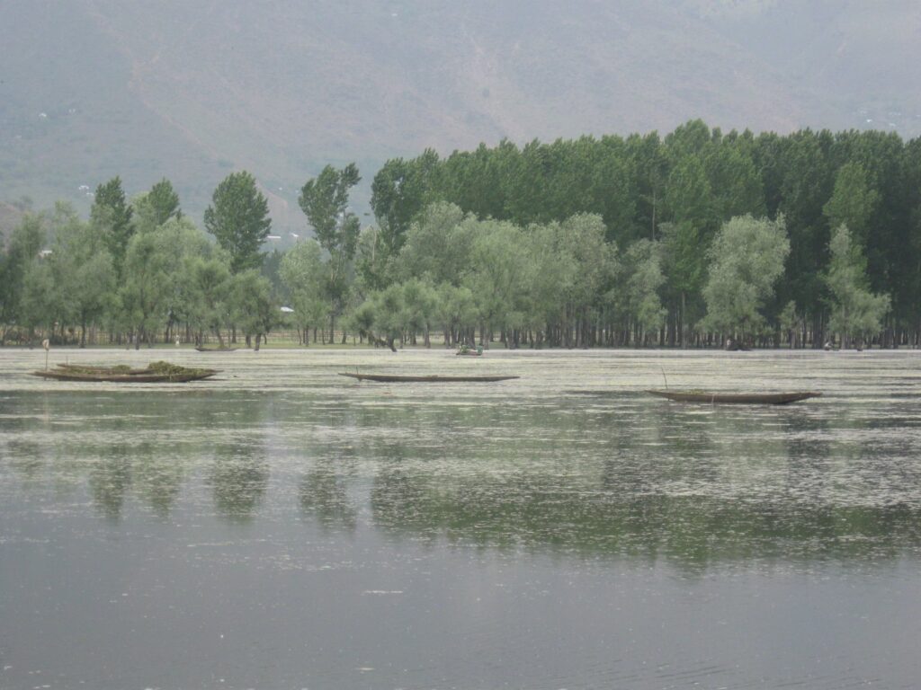
Wular Lake, set in the bowl of the Kashmir Valley between the districts of Bandipora and Baramulla in the union territory of Jammu and Kashmir, is one of the largest freshwater lakes in Asia and the largest freshwater lake in India by maximum extent. The lake is the floodplain reservoir of the Jhelum river and stretches roughly 16 kilometres east to west and 9.6 kilometres north to south at high water. Its surface area varies enormously with the seasons, swelling from about 30 square kilometres at low water in winter to between 130 and 260 square kilometres after the snow-melt peak in spring and the south-west monsoon, when the Jhelum spills out of its banks and floods the surrounding alluvial fan. Wular Lake was designated a Ramsar wetland of international importance on 23 March 1990 and is one of the most strategically important freshwater bodies of the Indian subcontinent because of its role as the natural flood absorber of the Kashmir Valley and the gateway through which the Jhelum exits towards Pakistan.
Origin and Geographical Setting
Wular Lake is a tectonic lake formed by the subsidence of the Kashmir basin during the late Pliocene and Pleistocene, when the rise of the Pir Panjal range and the Greater Himalaya to its north and south enclosed an intermontane trough that filled with lacustrine and fluvial deposits of the Karewa formation. The original Kashmir palaeo-lake has shrunk over the last million years to a handful of residual water bodies, of which Wular Lake is the largest. The bed of Wular Lake lies at an elevation of approximately 1,580 metres above mean sea level, and the lake is bounded to the north by the Harmukh range and to the south by the Jhelum’s gentle alluvial plain.
The Jhelum River and Wular Lake
The Jhelum river enters Wular Lake from the south-east near Banyari after flowing for about 170 kilometres from its source at Verinag through Anantnag, Srinagar, and Sopore. The river broadens dramatically as it enters the lake, depositing the bulk of its silt load and slowing to almost still water. The Jhelum then emerges from the western edge of Wular Lake near Sopore and flows north-west through Baramulla and Uri before crossing the Line of Control into Pakistan-administered Kashmir. This hydrological geometry makes Wular Lake the principal regulating reservoir of the Jhelum and the only natural shock absorber for floods that would otherwise inundate the densely populated Srinagar floodplain upstream and the Baramulla–Uri corridor downstream.
Catchment
The catchment of Wular Lake covers about 12,660 square kilometres, draining the western, northern, and central parts of the Kashmir Valley. The Madhumati and Erin streams contribute additional flow from the Harmukh and Gurez sides, but the Jhelum supplies more than 90 per cent of the inflow. The catchment is heavily forested in its upper reaches and intensively cultivated with paddy and orchards in its middle and lower reaches, and the changing land use of this catchment has been the principal driver of the changing condition of Wular Lake.
Biodiversity of Wular Lake
Wular Lake supports a rich assemblage of cold-water and freshwater species adapted to the high-altitude valley climate. The Ramsar dossier identified the lake as a wetland of outstanding importance for its avifauna, fishery, and floral diversity.
Birds
Wular Lake is a critical wintering ground for migratory waterbirds along the Central Asian Flyway, hosting between 100,000 and 500,000 birds in a peak season. Recorded species include the Greylag Goose, Bar-headed Goose, Mallard, Common Pochard, Northern Pintail, Common Teal, Tufted Duck, Eurasian Coot, and several species of pochards and grebes. Globally threatened species such as the Pallas’s Fish Eagle have been recorded breeding in the lake’s marginal woodlands.
Fish and Plants
Wular Lake supports about 17 species of fish, dominated by Schizothorax species (the Kashmir snowtrout), Cyprinus carpio (introduced), and Carassius carassius. The lake is a key spawning ground for the snowtrout fishery of the Jhelum and provides livelihood to about 8,000 fishing families. The aquatic vegetation includes extensive beds of Nelumbo nucifera (Indian lotus), whose seeds (nadru) and rhizomes are harvested commercially and are a staple of Kashmiri cuisine.
The Tulbul Navigation Project
Wular Lake is the centrepiece of one of the longest-running water disputes between India and Pakistan, the Tulbul Navigation Project. India proposed in 1984 to construct a regulator and barrage at the outflow of the lake near Sopore to maintain a minimum draught of 4.4 feet in the Jhelum during winter low-flow months, enabling navigation between Baramulla and Srinagar. The structure would have stored about 0.30 million acre feet of water in the upper reaches of Wular Lake.
Pakistan objected on the grounds that the project amounted to storage on a Western River and therefore violated the Indus Waters Treaty 1960, which assigned the unrestricted use of the waters of the Indus, Jhelum, and Chenab to Pakistan and limited Indian storage on these rivers to specified non-consumptive purposes. India maintained that the project was a navigation works permitted under the treaty. Talks under the Permanent Indus Commission produced no agreement, work on the project was suspended in 1987, and the Tulbul Navigation Project has remained dormant ever since, intermittently reopened in bilateral discussions. The dispute over Wular Lake is one of the most-cited examples of how the Indus Waters Treaty has handled trans-boundary infrastructure on shared rivers.
Threats to Wular Lake
Wular Lake has shrunk substantially over the last hundred years. Comparative analysis of survey records and satellite imagery shows that the open-water area of Wular Lake has declined from roughly 217 square kilometres in 1911 to about 86 square kilometres in 2008. The shrinkage has come from three interlocking causes. First, siltation from intensive land-use change in the Jhelum catchment has built up a fan of sediment that has converted vast areas of former lake bed into seasonally exposed marsh. Second, encroachment of the marshy fringes for paddy cultivation and willow plantations, including the state-sponsored willow plantations of the 1950s and 1960s, has shrunk the effective lake. Third, untreated sewage discharge from the towns around the lake and pesticide runoff from upstream orchards have degraded water quality and driven eutrophication.
Wular Conservation and Management Authority
In response to the steady deterioration of Wular Lake, the Government of Jammu and Kashmir set up the Wular Conservation and Management Authority in 2012 as the dedicated body for the rehabilitation of the lake. The authority is implementing a phased dredging programme, the removal of encroaching willow plantations, the relocation of fishing villages from inside the lake bed, and a catchment treatment programme funded by the central government and the National Plan for Conservation of Aquatic Ecosystems. By 2024 the authority had cleared an estimated 17 million cubic metres of silt and removed willow over an area exceeding 27 square kilometres, with measurable gains in the open-water extent during the post-monsoon months.
Wular Lake in Comparative Context
Wular Lake is one of the four major lacustrine wetlands of India studied together in physical geography — the others being Chilika Lake in Odisha, Vembanad Lake in Kerala, and Loktak Lake in Manipur. Wular Lake is also one of the most prominent Ramsar sites of India, and the Kashmir Valley in which it lies sits at the meeting point of the western Himalayan and Hindu Kush ecoregions that border two of the world’s recognised biodiversity hotspots.
Frequently Asked Questions
Is Wular Lake the largest freshwater lake in India?
Wular Lake is generally described as the largest freshwater lake in India by maximum seasonal extent, with the high-water area ranging between 130 and 260 square kilometres depending on the snow-melt and monsoon flows of the Jhelum. At low water in winter the lake shrinks to about 30 square kilometres, so the ranking depends on the season used for comparison.
When was Wular Lake designated a Ramsar site?
Wular Lake was designated a Ramsar wetland of international importance on 23 March 1990. The Ramsar dossier covers the lake and its associated marsh and floodplain habitats in Bandipora and Baramulla districts of Kashmir.
What is the origin of Wular Lake?
Wular Lake is a tectonic lake formed by the subsidence of the Kashmir basin during the late Pliocene and Pleistocene, when the rise of the Pir Panjal and Greater Himalaya enclosed an intermontane trough. The original palaeo-lake has shrunk over the past million years, and Wular Lake is its largest surviving remnant.
What river feeds Wular Lake?
The Jhelum river feeds Wular Lake, entering from the south-east near Banyari and exiting near Sopore on the western edge. The Jhelum supplies more than 90 per cent of the inflow to Wular Lake. The Madhumati and Erin streams contribute additional flow.
What is the Tulbul Navigation Project dispute?
The Tulbul Navigation Project is an Indian proposal to build a regulator at the outflow of Wular Lake near Sopore to maintain a minimum 4.4 feet draught in the Jhelum for winter navigation between Baramulla and Srinagar. Pakistan objects on the grounds that the project violates the storage restrictions on Western Rivers under the Indus Waters Treaty 1960. Work was suspended in 1987 and the dispute remains unresolved.
Why has Wular Lake shrunk?
The open-water area of Wular Lake has declined from about 217 square kilometres in 1911 to roughly 86 square kilometres in 2008 due to three causes: siltation from intensive land-use change in the Jhelum catchment, encroachment of the marshy fringes for paddy and willow plantations, and untreated sewage and pesticide runoff driving eutrophication.
What is the Wular Conservation and Management Authority?
The Wular Conservation and Management Authority was set up by the Government of Jammu and Kashmir in 2012 as the dedicated body for the rehabilitation of Wular Lake. It implements dredging, willow removal, fishing-village relocation, and catchment treatment programmes funded by the central government and the National Plan for Conservation of Aquatic Ecosystems.
Why is Wular Lake important for flood control in Kashmir?
Wular Lake is the only natural shock absorber on the Jhelum river inside the Kashmir Valley. By spreading flood waters across its 130 to 260 square kilometre floodplain during peak inflow, Wular Lake protects the densely populated Srinagar urban floodplain upstream and the Baramulla–Uri corridor downstream from much higher flood levels.
Tell Google you want more of this.
Add Anantam IAS as a preferred sourceOne tap, and this site shows up more often in your own Top Stories, AI Overviews and AI Mode. Remove it any time.






