

Landslides are the rapid movement of rock, soil and vegetation down a slope under the influence of gravity. India has 0.42 million square kilometres, about 12.6 percent of the country's land area, identified as landslide-prone by the Geological Survey of India. The July 2024 Wayanad landslide, which killed over 230 people, and repeated Himalayan events in Uttarakhand, Himachal Pradesh and Sikkim have made landslide disaster management a high-priority UPSC GS Paper III theme on disaster management, geography and climate adaptation.
What are landslides
Landslides are downslope movements of rock, soil and vegetation. The material may move by:
- Falling
- Toppling
- Sliding
- Spreading
- Flowing
Movements range from gradual creep to sudden, violent sliding. Landslides often occur in conjunction with earthquakes, floods and volcanic eruptions. Their extent depends on slope steepness, vegetation cover, tectonic activity, bedding plane of the rocks and rainfall.
Types of landslides
- Falls: Abrupt movement of materials detached from steep slopes or cliffs, moving by free-fall, bouncing and rolling.
- Creep: Slow, steady downslope movement of soil or rock, often imperceptible in the short term.
- Debris flow: Rapid mass movement in which loose soils, rocks and organic matter combine with water to form a slurry that flows downslope. Usually associated with steep gullies.
- Mudflow: Rapidly flowing mass of wet material with at least 50 percent sand, silt and clay particles.
- Flows: General term including creep, debris flow, mudflow and similar.
- Rockfalls, rock slides, earth slumps are other subtypes.
Causes of landslides
Geological causes
Weak, sensitive and weathered rock material, presence of joints and fissures, variation in physical properties such as permeability, and structural discontinuities in bedrock.
Morphological causes
Tectonic or volcanic uplift, erosion by wind and water, deposition of load on the slope or its crest, removal of vegetation cover at the toe.
Physical causes
Intense rainfall, earthquake or volcanic eruption, rapid snowmelt or freeze, cloudbursts, prolonged wet seasons.
Anthropogenic causes
- Excavation of the slope or its toe (road cutting, mining).
- Deposition of load on the slope (dumping of construction waste, illegal quarry spoils).
- Drawdown of reservoirs.
- Deforestation and removal of root networks.
- Unregulated mining.
- Irrigation that saturates slopes.
- Artificial vibration from construction and heavy vehicles.
Landslide-prone areas in India
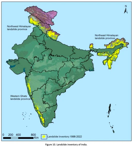
According to GSI, major landslide-prone zones include:
Western Ghats and Konkan Hills
Tamil Nadu (Nilgiris), Kerala (Idukki, Wayanad, Munnar), Karnataka (Coorg, Chikmagalur), Goa and Maharashtra. High-intensity rainfall on steep slopes creates frequent events. The 2024 Wayanad landslide is a recent catastrophic example.
Eastern Ghats
Araku region in Andhra Pradesh, parts of Odisha.
North-East Himalayas
Darjeeling (West Bengal), Sikkim, Arunachal Pradesh, Meghalaya (Jaintia Hills), Nagaland.
North-West Himalayas
Uttarakhand, Himachal Pradesh, Jammu and Kashmir. The 2013 Kedarnath disaster, the 2021 Chamoli flood, and the 2023 Himachal floods are significant events.
Why India's hills are landslide-prone
The Himalayan mountain ranges and the hilly tracts of the North-East are highly susceptible due to:
- Immature, rugged topography.
- Fragile rock conditions and continuing tectonic uplift.
- High seismicity from proximity to plate margins.
- High rainfall, especially during the monsoon.
- Extensive anthropogenic interference as part of developmental activities.
The Western Ghats, though located in a relatively stable tectonic domain, experience landslides because of steep slopes, high-intensity rainfall and anthropogenic activities. The Nilgiris, at the convergence of the Eastern and Western Ghats, face particularly protracted rainfall-induced landslides.
Impact of landslides
Short-term impacts
- Loss of life and property.
- Destruction to agricultural crops.
- Damage to vegetation.
- Obstruction of roads and rail, causing traffic jams.
- Temporary loss of livelihood for poorer communities.
Long-term impacts
- Increase in sediment load of rivers, raising flood risk.
- Reduced effective life of hydroelectric and multipurpose projects as silt fills reservoirs.
- Loss of cultivable land and infrastructure.
- Environmental impact through erosion and soil loss.
- Demographic impact through forced relocation.
- Frequent disruption of transportation networks, leading to geographical isolation and persistent underdevelopment.
Challenges in landslide response
- Most landslide-prone habitations are remote in Himalayan, North-Eastern and Western/Eastern Ghats regions. District administration and NDRF/SDRF teams struggle to reach them quickly.
- Rainy season weather and poor visibility make helicopter-based relief difficult.
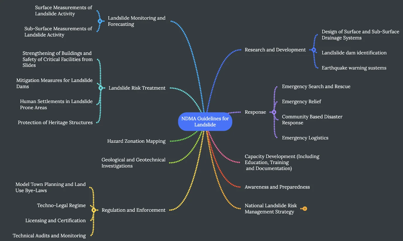
NDMA guidelines for landslide disaster management
- Landslide hazard, vulnerability and risk assessment: Delineate susceptible areas and assess resources at risk.
- Early warning systems: Continuous monitoring of movement, stress and rainfall, with regular data transmission.
- Investigations for landslide risk assessment: Multi-disciplinary investigations to formulate standards for mitigation.
Landslide risk mitigation and remediation
- Restrict development in landslide-prone areas through land use planning.
- Establish standards for excavation and construction.
- Protect existing developments through restraining walls and rock anchors.
- Slope stabilisation: modify topography, manage groundwater, improve drainage, remove soil/debris.
- Landslide insurance and compensation for losses.
- Regulation and enforcement: State governments and SDMAs must adopt the model techno-legal framework for compliance with land use zoning and landslide safety in all development activities.
- Awareness and preparedness: Comprehensive awareness campaigns targeting different groups in landslide-prone areas.
- Capacity development: Disaster Management (including landslides) in school curricula, training of administrators, technical capacity in institutes located in vulnerable areas.
- Immediate response: Standard Operating Procedures for coordinated and sustained action by multiple agencies after a landslide.
- Research and development: R&D for new investigation techniques, remote sensing, communications and instrumentation.
Geological Survey of India Landslide Atlas
The GSI National Landslide Susceptibility Mapping programme produces maps at 1:50,000 and 1:10,000 scales. The National Landslide Forecasting Centre, launched in 2023, aims to provide short-term landslide forecasts for selected districts, integrated with the IMD rainfall forecasts.
Latest developments (2024-26)
- Wayanad landslide (July 2024): Killed over 230 people; raised questions about Western Ghats land use, ecologically sensitive area demarcation and the Gadgil/Kasturirangan reports.
- Himachal and Uttarakhand monsoon (2024): Multiple landslide events closed highways and damaged hydroelectric projects.
- GSI Landslide Forecast Centre scaled up in 2024 with pilot operational forecasts for 17 districts.
- India Landslide Susceptibility Map completed for the Western Ghats in 2024.
- Disaster Management (Amendment) Bill 2024 introduced to strengthen NDMA, SDMA and DDMA with landslide preparedness as a priority.
- Ecologically Sensitive Area notifications for the Western Ghats pending finalisation since the Gadgil and Kasturirangan reports of 2011 and 2013.
- COP29 Baku (2024): India's adaptation narrative emphasised climate-attributable landslides and the need for stronger Loss and Damage funding.
- Forest (Conservation) Amendment Act 2023 has been criticised by environmentalists for potentially worsening landslide risk in deforested border and hilly areas.
UPSC Relevance
Prelims focus
- GSI landslide-prone area: 12.6 percent of India.
- Types of landslides: falls, creep, debris flow, mudflow, flows.
- Landslide-prone zones: Western Ghats, Eastern Ghats, NE and NW Himalayas.
- NDMA guidelines on landslides.
- National Landslide Forecasting Centre (2023).
- Gadgil and Kasturirangan reports on Western Ghats ESA.
Mains focus (GS III)
Typical question framings examine the causes of landslides, the role of climate change and deforestation, the gaps in land use regulation, and the effectiveness of NDMA guidelines. Strong answers cite specific disasters (Wayanad, Kedarnath, Chamoli), the Gadgil-Kasturirangan reports, the Forest (Conservation) Amendment Act 2023, and climate adaptation frameworks.
Linkages
Landslides connect to the Sendai Framework for Disaster Risk Reduction, SDG 11, SDG 13, India's updated NDCs after COP29, the Loss and Damage Fund, the Forest (Conservation) Amendment Act 2023, the Biological Diversity Amendment Act 2023, and the Disaster Management Act 2005.
Tell Google you want more of this.
Add Anantam IAS as a preferred sourceOne tap, and this site shows up more often in your own Top Stories, AI Overviews and AI Mode. Remove it any time.






