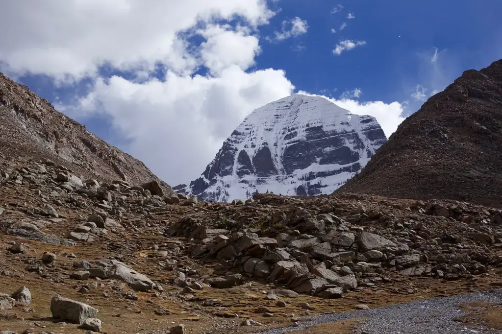
Kailash Mansarovar is two things at once, and most notes blur them. It is a physical landscape in western Tibet: Mount Kailash, a pyramid of dark rock in the Transhimalaya, with Lake Manasarovar spread at its foot. It is also a pilgrimage run by the Government of India, the Kailash Mansarovar Yatra, which has stopped and restarted with the temperature of India-China relations.
That double identity is exactly why the topic keeps turning up. A question can come from geography (which rivers rise here), from culture (why four faiths revere one mountain) or from international relations (Lipulekh, China, Nepal). An answer that knows only the pilgrimage, or only the map, loses half the marks.
The short version: the peak and the lake sit in the southwestern corner of the Tibet Autonomous Region of China, close to where India, Nepal and China meet. Four of the subcontinent’s great rivers rise in this landscape. The official yatra crosses into Tibet through two passes, Lipulekh in Uttarakhand and Nathu La in Sikkim, and it resumed in 2025 after no yatra was held from 2020 to 2024.
Where Mount Kailash and Lake Manasarovar Are
Mount Kailash and Lake Manasarovar lie in Burang (Pulan) County of Tibet, just north of the tri-junction with India and Nepal. The mountain belongs to the Kailash or Gangdise Range of the Transhimalaya, the ranges that run north of the Great Himalaya on the Tibetan side.
That last point trips up a lot of students. If you’ve been writing “Mount Kailash, a Himalayan peak”, you’re in good company, but it isn’t precise. Kailash stands behind the main Himalayan wall, on the edge of the Tibetan Plateau, which is why its rivers can flow north, south, east and west. The Himalaya proper lies to its south.
- Mount Kailash: 6,714 m, as given by the International Centre for Integrated Mountain Development (ICIMOD). Other surveys put it near 6,638 m, so a round “about 6,700 m” is safe in an answer.
- Lake Manasarovar: 4,550 m (ICIMOD), a high-altitude freshwater lake.
- Rakshastal: a saline lake just west of Manasarovar. A short natural channel, the Ganga Chhu, carries Manasarovar’s overflow into it.
- Kailash Sacred Landscape: about 31,000 sq km, shared by Pulan County in Tibet, Pithoragarh and part of Bageshwar districts in Uttarakhand, and the Darchula, Baitadi, Bajhang and Humla districts of western Nepal.
The pair of lakes is a gift for revision. Manasarovar is fresh, Rakshastal is salt, and one short stream joins them. Tradition casts them as light and dark, and the geography happens to agree.
The Four Rivers That Rise Around Kailash
Four major rivers of Asia rise in the glaciers of the Kailash landscape: the Indus to the north, the Sutlej to the west, the Karnali to the south and the Brahmaputra to the east. ICIMOD describes them as spokes radiating from one hub, and that image is worth keeping for the exam hall.
Here’s the misconception to avoid. None of the four simply flows out of Lake Manasarovar. They rise from glaciers and springs across the region, while the lake’s own overflow heads into Rakshastal. Write “rise in the Kailash-Manasarovar region”, not “rise from Manasarovar”.
| River | Direction from Kailash | Downstream identity | Ends up in |
|---|---|---|---|
| Indus | North | Flows northwest through Ladakh into Pakistan | Arabian Sea |
| Sutlej | West | Enters India in Himachal Pradesh; part of the Indus system | Arabian Sea, via the Indus |
| Karnali | South | Karnali in Nepal, Ghaghara in India | Ganga |
| Brahmaputra | East | Yarlung Tsangpo in Tibet, Brahmaputra in India | Bay of Bengal, via Bangladesh |
The practical payoff is that one mountain links three river basins that India shares with its neighbours. The Indus connects to Pakistan, the Karnali-Ghaghara to Nepal and the Ganga, and the Brahmaputra to China and Bangladesh. The detailed courses are in the notes on the Indus, Sutlej, Ghaghara and Brahmaputra river system.
Why Four Faiths Hold It Sacred
Mount Kailash is sacred to Hindus, Buddhists, Jains and followers of Bon, the pre-Buddhist religion of Tibet. ICIMOD notes that all four revere it as the centre of the universe, and the Ministry of External Affairs (MEA) describes it on the yatra portal as the abode of Lord Shiva for Hindus, with religious meaning for Jains and Buddhists too.
- Hindu tradition: Kailash is Shiva’s abode, and the yatra portal itself frames the pilgrimage around that belief.
- Jain tradition: Rishabhadeva, the first tirthankara, is believed to have attained liberation here. The founder of Jainism note covers the tirthankara line.
- Tibetan Buddhist tradition: legends tell of the yogi Milarepa winning the mountain in a contest with a Bon master.
- Bon: the mountain is the spiritual centre of the older Tibetan faith.
The pilgrimage itself centres on the kora (parikrama), a walking circuit of roughly 53 km around the mountain that usually takes about three days. Nobody climbs Kailash. There’s no recorded ascent, and the Chinese authorities prohibit climbing it because of its religious standing.
How the Kailash Mansarovar Yatra Works
The Kailash Mansarovar Yatra is a pilgrimage the MEA organizes every year between June and August or September, for Indian citizens with valid passports. It runs through two official routes and is fully self-financed. The MEA arranges transport, accommodation, food, medical tests and guides, but it gives no subsidy.
The selection is the part aspirants often get wrong. There’s no first-come queue and no quota by state. Applicants register on kmy.gov.in, and the yatris are picked by a fair, computer-generated, random and gender-balanced draw. The whole process has been computerized since 2015.
| Route | State | Official route since | Batches in 2025 | Batches in 2026 | What stands out |
|---|---|---|---|---|---|
| Lipulekh Pass | Uttarakhand | 1981 | 5 batches of 50 | 10 batches of 50 | About 22 days; estimated cost Rs 2.09 lakh per person in 2026 |
| Nathu La Pass | Sikkim | 2015 | 10 batches of 50 | 10 batches of 50 | Motorable; acclimatization halts at 17th Mile and Sherathang |
A few working facts complete the picture:
- The yatra runs in cooperation with the state governments of Uttar Pradesh, Uttarakhand and Sikkim and with the Indo-Tibetan Border Police (ITBP).
- Yatris are medically screened in Delhi and screened again near the pass before crossing.
- A helicopter airlift is provided on the Indian side for medical emergencies.
- The MEA has asked China to open more routes, including Shipki La in Himachal Pradesh. According to the MEA’s February 2026 reply in Parliament, China cited difficulties, and the government remains engaged on it.
The Nathu La route is covered in the Nathu La Pass note. Pilgrims who travel with private operators through Nepal are a separate stream altogether. They aren’t part of the MEA yatra, and that distinction mattered a great deal in 2026.
Suspension and Resumption, 2020 to 2026
No Kailash Mansarovar Yatra was held from 2020 to 2024. The MEA told Parliament in February 2025 that the yatra had not taken place since 2020 because of the COVID-19 outbreak and the Chinese side’s subsequent non-renewal of the yatra arrangements. The last yatra before the break was in 2019.
The restart came in steps, and each step is a date worth knowing:
- 18 November 2024: External Affairs Minister S. Jaishankar and Chinese Foreign Minister Wang Yi discussed resumption on the sidelines of the G20 summit in Rio de Janeiro.
- 18 December 2024: the issue came up at the 23rd meeting of the Special Representatives on the boundary question in Beijing.
- 27 January 2025: Foreign Secretary Vikram Misri and Vice Foreign Minister Sun Weidong agreed in Beijing to resume the yatra in summer 2025, alongside talks on hydrological data for trans-border rivers and direct flights.
- 26 April 2025: the MEA announced the 2025 yatra: 15 batches of 50, or 750 yatris, five via Lipulekh and ten via Nathu La.
- 20 June 2025: the Governor of Sikkim flagged off the first Nathu La batch, which included 13 women.
- 30 April 2026: the MEA announced the 2026 yatra, organized in coordination with the Government of China: 20 batches of 50, or 1,000 yatris, split equally between the two passes.
- 12 June 2026: Minister of State Pabitra Margherita flagged off the first 2026 batch in New Delhi. It travelled via Nathu La and stayed at new acclimatization centres.
- 23 August 2026: the tenth and final batch on the Lipulekh route returned to India, closing that leg of the yatra. All India Radio reported that 477 pilgrims made the Lipulekh journey in ten batches, starting on 4 July.
Notice what the numbers say. The yatra went from 750 pilgrims in 2025 to 1,000 in 2026, and the Lipulekh route doubled from five batches to ten. In a relationship where most signals are hard to read, the yatra is one of the few that can be counted. That is why the MEA calls it a “people-centric” step, and why it belongs in any note on India-China relations.
Lipulekh, Nepal and the Road to the Border
The Lipulekh route matters for two reasons: it’s the shortest way to Kailash from India, and Nepal disputes the territory around it. Both halves of that sentence come up in exams.
On infrastructure, the change has been dramatic. On 8 May 2020, Defence Minister Rajnath Singh inaugurated an 80 km road from Ghatiabagarh to Lipulekh Pass, climbing from 6,000 to 17,060 feet.
- Before the road, the Lipulekh route involved a trek of about 90 km through high-altitude terrain.
- With it, the government said, the yatra could be done in about a week instead of two to three.
- The share of the journey on Indian roads rose to 84 per cent, against 16 per cent in China.
On the dispute, India’s position is on record. In May 2026, responding to comments by Nepal’s Foreign Ministry about the yatra, the MEA spokesperson said Lipulekh has been a long-standing route for the yatra since 1954. He added that Nepal’s territorial claims are “neither justified nor based on historical facts and evidence” and that “unilateral artificial enlargement of territorial claims is untenable”. India said it remains open to resolving outstanding boundary issues through dialogue. The background is in India-Nepal relations, and the latest exchange is tracked in the current affairs note on Nepal’s encroachment remarks.
The August 2026 Floods and the Nepal Route
On 26 August 2026, a devastating flash flood struck the Bhote Koshi area on the Nepal-Tibet border, and many of the people caught in it were Indian pilgrims heading to or returning from Kailash. The MEA’s own briefing made clear that the affected groups had travelled through private tour operators by the Nepal route, not through the MEA yatra, and the last Lipulekh batch of the official yatra had already returned to India on 23 August.
- By 29 August, the MEA said 598 Indian nationals had crossed safely from China into Nepal and around 900 were still on the Chinese side, safe and contactable.
- More than 275 Indian nationals and 128 persons of Indian origin remained missing or non-contactable.
- Three Indian Air Force aircraft had carried about 57.5 tonnes of relief material to Nepal, and India sent Army tunnel-rescue and forensic teams.
The cause is a lesson in Himalayan hazards. Reports traced the flood to a glacier collapse at about 5,200 m that sent ice and rock into the Lhende River, damming it until the dam gave way. That isn’t a classic glacial lake outburst, but it’s a close cousin, and the note on glacial lake outburst floods explains the family. The event itself is covered in the current affairs note on the Nepal glacial collapse.
Kailash Mansarovar at a Glance
| Item | Fact |
|---|---|
| Location | Burang (Pulan) County, Tibet Autonomous Region, China |
| Range | Kailash (Gangdise) Range of the Transhimalaya |
| Height of Mount Kailash | 6,714 m (ICIMOD); other surveys about 6,638 m |
| Altitude of Lake Manasarovar | 4,550 m (ICIMOD) |
| Neighbouring lake | Rakshastal, saline, linked by the Ganga Chhu |
| Rivers rising in the region | Indus, Sutlej, Karnali (Ghaghara), Brahmaputra (Yarlung Tsangpo) |
| Faiths | Hinduism, Buddhism, Jainism, Bon |
| Circuit (kora) | Roughly 53 km, about three days |
| Organizer of the official yatra | Ministry of External Affairs, with China |
| Official routes | Lipulekh (since 1981), Nathu La (since 2015) |
| Yatris selected | 750 in 2025; 1,000 for 2026 (477 completed the Lipulekh route) |
| Gap years | No yatra from 2020 to 2024 |
How Kailash Mansarovar Is Tested
Kailash Mansarovar is tested as a map fact in Prelims and as an argument in Mains. The Prelims question is usually a matching exercise, while the Mains question wants you to use the yatra as evidence.
For Prelims, these pairs carry most of the risk:
- River and direction: Indus north, Sutlej west, Karnali south, Brahmaputra east.
- Pass and state: Lipulekh with Uttarakhand, Nathu La with Sikkim, Shipki La with Himachal Pradesh.
- Lake and water: Manasarovar fresh, Rakshastal saline.
- Range: Transhimalaya, not the Great Himalaya.
For Mains, the yatra is useful material in at least three kinds of answer. It works as a confidence-building measure in India-China ties. It shows how border roads double as strategic and pilgrimage infrastructure. And the 2026 floods illustrate why Himalayan pilgrimages need disaster preparedness across borders.
The revision method that works is a single sketch. Draw the mountain, put the two lakes below it, add four arrows for the rivers and mark the two passes in India. If you can reproduce that sketch from memory, you can answer almost any factual question on the topic.
The Verdict
Kailash Mansarovar should be studied as geography first and pilgrimage second. The rivers, the range and the lakes don’t change, and they’re where the easy marks sit. The yatra is the part that moves, so it’s worth tracking each year through the MEA’s own announcements rather than through travel sites, which routinely mix up the official yatra with private tours via Nepal.
If you remember one thing, make it this: the batch count is the barometer. Zero from 2020 to 2024, 750 in 2025, 1,000 in 2026. Few numbers in the syllabus tell you so much about a relationship in so few digits.
Frequently Asked Questions
Where is Kailash Mansarovar located?
Mount Kailash and Lake Manasarovar lie in Burang (Pulan) County in the southwestern Tibet Autonomous Region of China, just north of the tri-junction with India and Nepal. The wider Kailash Sacred Landscape also takes in parts of Uttarakhand and western Nepal.
Which rivers originate near Mount Kailash?
Four major rivers rise in the Kailash landscape: the Indus to the north, the Sutlej to the west, the Karnali (Ghaghara in India) to the south and the Brahmaputra (Yarlung Tsangpo in Tibet) to the east. They rise from glaciers and springs in the region, not from Lake Manasarovar itself.
What are the routes of the Kailash Mansarovar Yatra?
The Ministry of External Affairs runs the yatra through two official routes: Lipulekh Pass in Uttarakhand, used since 1981, and Nathu La Pass in Sikkim, used since 2015. In 2026 each route was allotted 10 batches of 50 yatris.
When did the Kailash Mansarovar Yatra resume?
The yatra resumed in 2025 after no yatra was held from 2020 to 2024. India and China agreed on 27 January 2025 to restart it, and 750 yatris travelled in 15 batches in 2025. For 2026 the MEA announced 20 batches, or 1,000 yatris.
How are pilgrims selected for the Kailash Mansarovar Yatra?
Applicants register online on the official yatra portal, and the MEA selects yatris through a fair, computer-generated, random and gender-balanced draw. The yatra is self-financed, and the ministry provides no subsidy.
Why is Lipulekh Pass controversial?
Nepal claims the territory around Lipulekh. India’s position, restated by the MEA in May 2026, is that Lipulekh has been a yatra route since 1954 and that Nepal’s claims are neither justified nor based on historical facts, while India stays open to dialogue on boundary issues.
Is Lake Manasarovar freshwater or saltwater?
Lake Manasarovar is a high-altitude freshwater lake. Its overflow runs through a short channel, the Ganga Chhu, into the neighbouring saline lake Rakshastal.
Has anyone climbed Mount Kailash?
There is no recorded successful ascent of Mount Kailash. Chinese authorities prohibit climbing because of the mountain’s religious importance, and pilgrims instead walk the kora, a circuit of roughly 53 km around it.
Practice Questions
Prelims MCQs
Q1. Consider the following rivers: 1. Indus 2. Sutlej 3. Karnali 4. Ganga. Which of the above rise in the Kailash-Manasarovar region?
(a) 1 and 2 only
(b) 1, 2 and 3 only
(c) 2, 3 and 4 only
(d) 1, 2, 3 and 4
Answer: (b) The Indus, Sutlej, Karnali and Brahmaputra rise in the Kailash landscape; the Ganga rises at Gangotri in Uttarakhand.
Q2. Mount Kailash is part of which of the following?
(a) Great Himalaya
(b) Shiwalik Range
(c) Transhimalaya
(d) Pir Panjal Range
Answer: (c) Kailash belongs to the Kailash or Gangdise Range of the Transhimalaya, north of the Great Himalaya.
Q3. Consider the following pairs (Pass : State): 1. Lipulekh : Uttarakhand 2. Nathu La : Sikkim 3. Shipki La : Himachal Pradesh. How many of the above pairs are correctly matched?
(a) Only one
(b) Only two
(c) All three
(d) None
Answer: (c) All three pairs are correct; Lipulekh and Nathu La are the official yatra routes and Shipki La is a proposed additional route.
Q4. With reference to the lakes near Mount Kailash, which statement is correct?
(a) Both Manasarovar and Rakshastal are freshwater lakes
(b) Manasarovar is freshwater while Rakshastal is saline
(c) Manasarovar is saline while Rakshastal is freshwater
(d) Both lakes are saline
Answer: (b) Manasarovar is freshwater and overflows through the Ganga Chhu into the saline Rakshastal.
Q5. The Kailash Mansarovar Yatra organised by the Government of India is conducted by which ministry?
(a) Ministry of Culture
(b) Ministry of Tourism
(c) Ministry of Home Affairs
(d) Ministry of External Affairs
Answer: (d) The MEA organises the yatra in coordination with China, state governments and the ITBP.
Mains Questions
- Mount Kailash is described as the hub from which four great rivers of Asia radiate. Explain the geographical setting of the Kailash-Manasarovar region and its hydro-political significance for India. (15 marks, 250 words)
- Examine the Kailash Mansarovar Yatra as a confidence-building measure in India-China relations, with reference to its suspension and resumption. (10 marks, 150 words)
- Border roads such as the Ghatiabagarh-Lipulekh road serve strategic, economic and pilgrimage purposes at once. Discuss with reference to India’s Himalayan frontier. (15 marks, 250 words)
- Why do cross-border pilgrimages in the Himalaya need joint disaster preparedness? Illustrate with recent flood events affecting Kailash pilgrims. (10 marks, 150 words)
- Shared sacred geographies can both connect and divide neighbours. Discuss with reference to Kailash-Manasarovar and the Lipulekh dispute with Nepal. (15 marks, 250 words)
Tell Google you want more of this.
Add Anantam IAS as a preferred sourceOne tap, and this site shows up more often in your own Top Stories, AI Overviews and AI Mode. Remove it any time.